1. |
GENERAL INFORMATION |
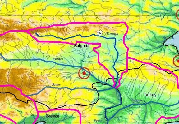
TUNDJA / TUNCA RIVER Sub-basin
(sub-basin shared by Republic of Bulgaria and Turkey) |
Tundja river is part of the Maritza/Evros/Meriç sub-basin, including Arda and Ergene tributaries (see chapter 4.13), and one of the major river systems located in the eastern Balkans.
It has a length of 350 km and a size of 7,780 km² in Bulgaria. Main cities are Kazanlak, Sliven (136,000 inhabitants) and Yambol (110,000).
The river then crosses into Turkey as Tunca (200 km²) before flowing into Maritza/Evros/Meric river at the GR-TR border in the city of Edirne (TR).
|
Bulgaria |
Turkey |
1.1. Geographical properties |
Longitude/latitude at downstream river outlet |
- Latitude at outlet:42 43 40 N
- Longitude at outlet: 24 58 10
|
- 260 34’ 46” E
- 41O 50’ 52” N
|
Size of basin |
7,784 km² |
Nearly 200 km² |
Length and width in km |
350 km |
Nearly 30 km on Turkish territory |
Topography, including altitude range in m |
The river springs from Stara Planina Mountain, at 1,900 m asl.
Altitude range: 0 m to 1,900 m |
- Altitude range : 50 m
|
Geology |
The River Tundja springs out in the Kalofer part of the Stara Planina Mountain. In its upper reaches the river flows southwards and upon passing Kalofer turns towards the east to flow across the Kazanlak, Sliven, and Straldja lowlands. Near the village of Zavoi, the river turns southward to flow across the Yambol – Elhovo valley. |
- Kalker Marl and limestone
|
Rainfall, average annual and seasonal distribution, etc. |
Average annual precipitation for the river basin is 617 mm. The precipitation has minimum in August and September with a secondary winter minimum, but in some sectors of the river basin in February and March. |
- The long term average annual rainfall is 589 mm with 134.5 standard derivation. The catch-ment is characterized by Mediterranean climate
|
River(s), with lengths and average annual flows and seasonal distribution - flood and drought incidence and impact |
River |
Catchment area A (km²) |
Annual Runoff Qav* (m³/s) |
Taia |
86.83 |
1,925 |
Eninska |
45.2 |
0.731 |
Asenovska |
74.5 |
0.818 |
Mochuritca |
1,108 |
2,754 |
Marash |
89.74 |
0,44 |
|
River |
Catchment area A (km²) |
Annual Runoff Qav* (m³/s) |
Tunca |
7,982 |
19.24 |
|
1.2. Demographic properties |
Bulgaria |
Turkey |
General location of the basin |
The river length up to the Turkish border is 350 km. The catchment area is 7,784 km² and the average altitude of the catchment is 386 m SEL. River Tundja forms its runoff from the Central part of Eastern Stara Planina and from the Northern slopes of the Sredna Gora Mountain. The mid and downstream sections of the river cross the Kazanlushka valley, as well as several fields and low lands located in the eastern part of Southern Bulgaria. |
The river forms for some 15 km a short border between Turkey and Bulgaria and then flows in Turkey nearly 30 km with 200 km² drainage basin that belongs to Turkey |
Total population in basin |
520,900 people |
Lalapaşa town: 10,767 people |
Population of principal cities or towns |
Sliven (100,695 p.e.)
Yambol (82,925 p.e.)
Kazanlak (54,020 p.e.)
Karnobat (20,710 p.e.)
Elhovo (12,420 p.e). |
Lalapaşa town: 10,767 people |
Average per capita income |
Not applicable |
(US $/year): nearly 5,000 |
Industrial and agricultural GDP (Gross Domestic Product) |
Not applicable |
Not applicable |
Population living below the poverty line |
Not applicable |
Not applicable |
Other relevant characteristics |
Out of the total population in the basin, approx. 60 % are connected to a sewerage system and 29 % to a WWTP. The towns that have WWTP are:
Sliven (109.090 p.e.) and Kazanlak (58.520 p.e.). a WWTP is planned to be constructed for the town of Yambol (89.835 p.e.). |
Lalapaşa sewerage system |
1.3 LAND USES |
Bulgaria |
Turkey |
The main land uses include park land and protected fauna/flora areas, skiing, forestry, grazing, dry and irrigated agriculture, hydro-electricity, urban and scattered industry, fish farming and ponds and coastal tourism. |
Agricultural and recreational area |
2. WATER RESOURCES / USES AND ENVIRONMENT SITUATION |
Total available surface and groundwater resources |
1,163 x 106 m³ |
N/A |
Net usable capacity of surface reservoirs |
533 x 103 m³ net usable capacity |
Suakaçağı reservoir planned with Bulgaria |
Total surface water abstractions (estimated where not measured) |
122 water intakes |
? |
Total groundwater abstractions (estimated where not measured) |
Not applicable data |
? |
Surface and groundwater quality (in general categories only) |
Preliminarily category II for the river flow |
Observed regularly by EIE Number of the station is 104 |
Water uses (total, by sector, principal uses, current (estimated) and future (projected), include in-stream uses (fisheries, etc.) where appropriate) |
Irrigation, industrial water supply, fisheries |
Water supply for agricultural purposes |
Deficits and other resource concerns (e.g. quality, extremes, environmental degradation) |
?? |
Average Flow: 19,24 m³/s
Max flow: 545 m³/s
Min Flow: 0 m³/s |
ENVIRONMENTAL PROPERTIES |
Sensitive ecosystems, biodiversity and environmental impacts in the basin |
?? |
The river is importand for recreational use for the City of Edirne. Historical Kırkpınar oil wrestling competition (650 years old) is being arranged in this area. |
3. BASELINE INFORMATION AVAILABILITY |
Observation networks |
There are 11 hydrometric gauging stations installed in the basin, 6 of which are on the main stream and the rest on the tributaries. They all belong to the national river-monitoring network of the Ministry of the Environment and Water (MOEW). Hydrological and meteorology-cal data are available for the basin for the last 30 years. |
Water quality and flow monitoring on the river by EIE at the 105 no station |
Maps, with available scales, GIS and remote sensing imagery |
Available |
Avaliable |
Data archives and their adequacy |
- Ministry of Environment and Water (MoEW)
- Executive Environment Agency
- Ministry for Regional Development and Public Works (MRDPW)
- Municipalities and water companies
- NIMH
|
Electrical Power Resources, Survey and Development Administration of Turkey is measuring the parameters related to water quality and flow.
DSI (State Hydraulic Works) is responsible for all water-related issues. |
Research centres |
BASc (NIMH) and UASG |
DSI Regional office located in Edirne, Universities (ITU), Turkish Scientific and Research Concuil |
NAME AND CONTACT DETAILS OF PERSON(S) COMPLETING THIS FORM |
Prof. Roumen Arsov
University of Architecture, Civil Engineering and Geodesy, Faculty of Hydrotechnics
1, Christo Smirnenski blvd., 1046 Sofia, BG
Tel: (+ 359 2) 9635245/ext.663
Fax: (+ 359 2) 8656648
Email r_arsov_fhe@uacg.bg
Assoc.Prof. D-r.Snejana Dakova
NIMH-BASc, 66 «Tzarigradsko shausse» bul
1784 Sofia, Bulgaria
E-mail Snejana.Dakova@meteo.bg
Tel (+359 2) 975 39 86; Fax (+359 2) 9880380 |
Dr. Sevket COKGOR
Istanbul Technical University, School of Civil Engineering, Department of Hydraulics,
34469, Maslak, Istanbul, Turkey
Tel: +90 212 285 6848
Fax : +90 212 285 3710
cokgor@itu.edu.tr |
Bulgaria |
Turkey |
4. MANAGEMENT SETTING |
4.1. International agreements / conventions and national legislation |
The basic framework for the management of cross-border water bodies, the Helsinki Convention (1992) signed by Bulgaria.
There is no agreement between Bulgaria and Turkey for the Tundja river basin. Some seasonal agreements exist with TR for water releases from the BG dams. |
For this information please see the BG section in chapter 3.11
|
|
4.2. Institutions / distribution of responsibilities |
For this information please see the BG section in chapter 3.11
|
State Hydraulic Works (DSI) is responsible for all surface and sub-surface water resources in Turkey (monitoring and planning, designing, constructional, and operational activities) based on the following law:
Law no. 6200: DSI's Establisment Law, enacted: Dec. 18, 1953, published in Official Gazette: Dec. 25, 1953, Effective: February 28, 1954 |
4.3. Planning / Decision making processes |
For this information please see the BG section in chapter 4.11
|
Decisions are shared between the Ministry of Energy and Natural Resources and the Ministry of Environment and Forestry, and local communities.
State Hydraulic Works (DSI) does the planning and has several irrigation projects.
The Ministry of Environment and Forestry has carried out several wastewater treatment projects in the basin. |
4.4. Finances |
For this information please see the BG section in chapter 3.11
|
All projects related to water resources such as irrigation, flood protection, water etc. are supported by TR national funds. |
Bulgaria |
Turkey |
4.5. Past and present major projects (including listing of donors’ interest) |
The following projects and research have been developed for the Tundja river basin:
- Review of water pollution in transboundary river basins: Maritsa, Tundja, Arda, Mesta and Struma. Phare 1999 (July). Draft Final Report.
- Research Studies, Expertise and Consulta-tions for Different Engineering Structures on the South Bulgarian Rivers: Struma, Mesta, Arda, Maritsa and Tundja, 1998 – 2002, St.Modev.
- Feasibility Study for Identification of Sensitive Areas in Mesta, Struma, Arda, Tundja and Maritza River Basins in Accordance with the Criteria of Directive 91/271/EEC, 2003, LDK Consultants, Engineers and Planners, Athens, MoEW – Project BG No 9904-04.02
- Review of Water Pollution in the Cross Border Region of South Bulgaria, PHARE Programme, Carl Bro Group, July 1998.
- Water Quality Protection and Management in Maritza River Basin, Diagnostic Study of the nature, magnitude and sources of water pollution in the basin of Maritsa River and its tributaries, UN, Department of Economic and Social Affairs, Sofia, Sept. 1998.
- Evaluation of the Assimilative Capacity and Admissible Pollutant Load in the Maritsa River and its Tribulataries, UNDP, Ministry Of Environment And Water UN Department For Development Support and Management Services, Vodokanalengineering, July 1998.
In addition, two wastewater treatment plants (WWTP) have been built in the Tundja river basin at the towns of Karlovo and Sliven. |
Dikes for flood protection for the city of Edirne. |
4.6. Stakeholder Participation |
For this information please see the BG section in chapter 3.11 |
The Tunca river section in TR is very short, so it is not relevant for itself. |
4.7. Awareness / Communication |
All projects and activities related to water and environment in the Tundja river basin face public awareness. Communica-tions between the responsible institutions, stakeholders and society are good and in accordance to the national legislation. |
Generally speaking, the level of public awareness in the entire country is high. Local people oppose pollution of surface water from industrial activities. |
Bulgaria |
Turkey |
5. CONCLUSIONS / RECOMMENDATIONS |
5.1. Identification of critical problems (transboundary situation)
- problems related to the resource
- problems associated to uses, needs and demands
- problems affecting ecosystems |
Problems, related to water resources:
- Global climate change affected the region over the last 20 years, resulting in a ca. 30 % decrease of precipitation and associated water resources.
- Transboundary river water resource distribution between BG and TR has not created any problems so far.
Problems, associated with the uses, needs and demands:
- A shortage of water for drinking and irrigation exists in some settlements and regions.
- Construction of additional dams is necessary for water supply and irrigation.
Problems affecting ecosystems:
- Construction of WWTPs is necessary for most of the towns and for some industrial enterprises in the basin.
|
Water discharge depends on the operating rules of Bulgarian dams where zero discharge can occur in the summer period. An agreement is necessary between the 3 countries for discharges and also ecological issues.
Major problems are untreated industrial wastewater discharges and pollution from the overuse of fertilizers and pesticides. Uncontrolled water supply for irrigation and industrial purposes is also an important problem. |
5.2. Main achievements |
- Centralized water supply system for more than 98 % of the population
- Regular and long term monitoring of river water quantity and quality as a part of the National monitoring network. Part of it belongs to the EUROWTERNET.
- Inventory of water pollution sources and loads
- Establishing and maintenance of river water quality categories along the river reaches.
- Establishing of River Basin Directorate and associated River Basin Council, according to the National and EU legislation.
- Existence of Regional Inspectorate of Environment and Water
- Established “sensitive” and “less sensitive” zones in the river basin
|
|
5.3. Key challenges |
- Construction of WWTPs at the settlements over 100,000 PE (by 2011) and over 2000 PE (by 2015)
- Development of a River basin Management Plan (by 2009) according to the Water Act and EU WFD.
|
|
5.4. Donor interests |
The necessary major investments in the water sector in the region is expected to come from international sources and mainly from EU preaccession funds (ISPA programme – by 2007), cohesion and structural funds (after 2007), etc. |
There is no recognized special donor interest. |
5.5. Recommended priority actions |
- Construction of WWTP at the towns of Kalofer, Sopot and Yambol
- Development of a River Basin Management Plan
|
- Further increase the public awareness for ecological issues;
- update the water supply planning for irrigation and industries,
- effective treatment of industrial and municipal wastewater.
|
6. MAIN REFERENCES, BACKGROUND DOCUMENTS |
Water Act (1969 amended 1999 - 2004)
Regulations, associated with the Water Act (1999) – 12 in number
National Strategy for Development and Management of Water Resources (2004)
Implementation Program for Directive 91/271/EC Concerning Urban Wastewater Treatment (2003), MEW, Sofia
National Program for Construction of Sewer Networks and Main Trunks to the WWTPs for Settlements with Over 10 000 PE (2001), MRDPW, Sofia
National Program for Priority Construction of Urban Waste water Treatment Plants for Settlements with Over 10 000 PE (1999), MEW, Sofia
Ordinance for Establishing of Sensitive Zones (2003), MEW, Sofia |
Data from State Hydraulic Works and the Ministry of Environment and Forestry of Turkey;
Internet, private sources. |
|