| 1. |
GENERAL INFORMATION |
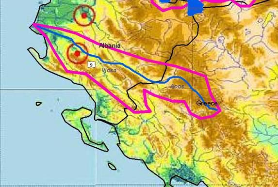
AOOS / VJOSA RIVER Sub-basin
(sub-basin shared by Greece and Albania) |
Aoos River originates from Mavrovouni mountain (part of the Northern Pindos mountain chain in Greece). It flows in NW direction through Albania and discharges into the Adriatic Sea. The total length of the river is about 260 km, with the first 80 km in Greece. The catchment has a total of 6,519 km², where the Greek sub-river basin covers approximately 2,154 km2.
The mean precipitation height in the area is about 850 mm and the flow rate varies between 8 and 130 m³/s.
The area is located in the Greek region of Ipiros (prefecture Ioannina). The river is part of the Vikos-Aoos National Park, where hunting is mostly prohibited. The region is mainly mountainous with special beauty and very rich flora and fauna. The river section between the village of Vovoussa and the city of Konitsa (60,000 inhabitants) is used for different water sports (rafting and canoe-kayak). Traditional old Greek villages like the Zagorohoria of particular tourist interests are located in the area.
|
Greece |
Albania |
1.1. Geographical properties |
Longitude/latitude at downstream river outlet |
? |
Vjosa (Mifol) 40º 38’, 19º 28’ |
Size of basin |
| 2,154 km² are on Greek territory |
4,365 km² are on Albanian territory |
Length and width in km |
| 70 km |
190 km (in Albania) |
Topography, including altitude range in m |
| Mean slope of the river basin is Im = 28% and mean altitude is 885m. The relief is very diverse with a distribution of altitudes 200 – 1,400 m standing for the 75% of the total, 1,400 – 2,000 m (20,5%) and 2,000 –2,600 m (0,1%). The Aoos’s valley width varies from 24 m to 25 km. |
0 to 1,600m |
Geology |
| Mostly phlysch, plyschoeids and relative forma-tions, and an important portion of calcareous . |
Calcareous rocks (from border-Pocem)
Quartenary alluvium (Mifol and Vjosa delta) |
Rainfall, average annual and seasonal distribution, etc. |
| Moderate Mediterranean climate. Summer is relatively warm (20-24° C) and dry (20-24 mm monthly average) whereas winter is mild and humid (150-250 mm monthly average). In the mountain areas rain exceeds 2,000 mm but it progressively falls to 800-100 mm in the semi mountainous areas. |
Average rainfall: Permet: 1,218mm
Gjirokaster: 1,680mm
Vlore: 900mm
Seasonal distribution:
Winter Spring Summer Autumn
Permet: 489mm 245mm 95mm 389mm
Gjirokaster: 740mm 320mm 70mm 550mm
Vlore: 320mm 200mm 70mm 310mm |
River(s), with lengths and average annual flows and seasonal distribution - flood and drought incidence and impact |
• Annual flows at the mouth: 3.7 km³/y
• Minimum flow in August (43m³/s) and maximum in January (335m³/s).
• Mean discharge at country boundary: 52m³/
Sarantaporos catchment: 870 km²
Voidomatis catchment: 384 km²
|
River name Catchment Average flow
Vjosa 6,519 km² 26 m³/s
Drino 1,320 km² 32.3 m³/s
|
1.2. Demographic properties |
General location of the basin |
| The Aoos river sources are at the Pindos mountains (in GR) |
The river crosses Albania from SE to SW and ends at the Adriatic Sea. |
Total population in basin |
| 19.081 inh. (1981) |
327,622 inh. |
Population of principal cities or towns |
Konitsa: 2,858 inhabitants
Chrisovitsis: 1,100
Kalpaki: 762; Mileas: 603; Petras: 439;
Asprageloi: 211; Ag. Paraskeui : 394
|
Permet: 36,746 inhabitants
Tepelene: 45,538
Vlore: 179,497
Gjirokaster: 65,841 |
Average per capita income |
? |
512.8 US$/year |
Industrial and agricultural GDP (Gross Domestic Product) (2003) |
? |
16.13 billion $ (estimated in 2003) |
Population living below the poverty line |
? |
30% (estimated in 2001 |
Other relevant characteristics |
? |
Albania is a country in transition |
1.3 LAND USES |
Mostly forested with some agricultural activity in the Konitsa valley before the Albanian border.
Susceptible to erosion due to geology.
|
The main land uses include parkland and protectted fauna/flora areas, skiing, forestry, grazing, dry and irrigated agriculture, hydro-electricity, urban and scattered industry, fish farming and ponds and coastal tourism. |
2. WATER RESOURCES / USES AND ENVIRONMENT SITUATION |
Total available surface and groundwater resources |
? |
The Vjosa basin is rich in groundwater resources; it includes three main aquifers.
47 main springs are identified. |
Net usable capacity of surface reservoirs |
? |
No storage capacity on either river |
Total surface water abstractions (estimated where not measured) |
? |
• Annual discharge volume: 5,550 million m³, specific discharge: 26 l/s.km²
• ratio wettest month (April) to driest month (August): 10.8
• at downstream river outlet: 204 m³/sec |
Total groundwater abstractions (estimated where not measured) |
Measured at the river mouth: 1,6 km3/y |
Along the lower valley of the Vjosa: > 1m³/sec
Well fields of Novosela: > 80 l/sec
Around Saranda and Butrinti: > 100 l/sec
Drino valley: > 90 l/sec
Blue eye: 20 m³/sec
| Hydrometric Point |
Volume ( 106 m³ ) |
| Vjosa-Petran |
630 |
| Vjosa-Dorze |
1,640 |
| Drino (Lekli Bridge) |
394 |
|
Surface and groundwater quality (in general categories only) |
Tables of physico-chemical and biological quality are given (summer 2001)
|
Chemical analyses of samples taken from the Vjosa showed that water quality is generally good; some high values have been observed for iron or hardness in the mainstream of Vjosa, for the contents of chlorine in the torrent of Langarica, but from the global point of view this river has the best water quality of the country, adequate for all uses |
Water uses (total, by sector, principal uses, current (estimated) and future (projected), include in-stream uses (fisheries, etc.) where appropriate) |
? |
Water is used for irrigation and supply of urban areas |
Deficits and other resource concerns (e.g. quality, extremes, environmental degradation) |
| Floods |
Floods |
ENVIRONMENTAL PROPERTIES |
Sensitive ecosystems, biodiversity and environmental impacts in the basin |
• Non-point sources of pollution: Agriculture farms mostly located in the Konitsa area
• Point sources of pollution: Aquaculture in the Voidomatis tributary and trash from Konitsa town
• Dams and diversions: The planned dam in the area of Kalivac would inundate a vast area of unique beauty and most important for the self-purification capacity of the river. The dam would split the river in two distinct parts.
|
Urban settlements (sewage, trash, housing), petrol abstraction in the middle-lower part of the river, sand and gravel extraction. |
3. BASELINE INFORMATION AVAILABILITY |
Observation networks |
? |
15 hydrometric gauging stations installed in the basin, 7 of which are on the main steam and the rest on the tributaries. |
Maps, with available scales, GIS and remote sensing imagery |
? |
Watersheds Map, 1: 800,000
Maps 1:50000 (Albanian, English )
Geologic-Engineric map of Albania, 1: 200,000
Topographic map 1:200,000 (ARC/INFO GIS data format)
Military topographic map 1:25,000 (ARC/INFO GIS data format)
Hydrological map 1:100,000
|
Data archives and their adequacy |
Monitoring systems for information related to their availability to the public are inadequate, inaccurate, non reliable, not consistent and deficient in general.
But there are some scientists (as Profs Fresheri and Pano) who have a very good idea as to the geology and hydrology of this river.
|
• Hydrologic and meteorologic data are available for the basin for the last 30 years.
• Data are not publicly available but can be accessed via national agencies.
|
Research centres |
| EKBY (Greek Biotope/Wetland Centre) |
National river-monitoring network of the Hydrometeorological Institute |
NAME AND CONTACT DETAILS OF PERSON(S) COMPLETING THIS FORM |
Prof. Jacques GANOULIS
Hydraulics Laboratory
Civil Engineering Department
Aristotle University of Thessaloniki
54124 Thessaloniki, Greece
Tel: +30-231-099.56.82
Fax: +30-231-099.56.81
e-mail: iganouli@civil.auth.gr
|
M.Sc. Manjola Banja Harja, Deputy Director
Hydrometeorological Institute, Tirana
Street e Durresit, No. 219, Tirana, Albania
Tel: (+355)(4) 259 360 / 22 35 18
Fax: (+355)(4) 22 35 18
e-mail: mbanja2002@yahoo.com
Msc. Emirjeta Adhami
Hydrometeorological Institute, Tirana
Department of Environment
Tel: (+355)(4) 22 35 18 / 22 24 39
Fax: (+355)(4) 22 35 18
Email: thadhami@icc-al.org
|
Greece |
Albania |
4. MANAGEMENT SETTING |
4.1. International agreements / conventions and national legislation |
There is no bilateral agreement between Greece and Albania for river management but a Memorandum of Understanding to develop a joint Agreement on Water Economy from 2003 (bilateral negotiations then started).
Convention on the Protection and Use of transboundary rivers and lakes, Helsinki [1992]
Espoo Convention (ratified by both sides).
|
This is the only river in Greece flowing to Albania. The river valley, part of the Vikos-Aoos national park, is very well known for its natural beauty.
Local authorities from both sides need assistance to complete their tasks.
A part of the river’s catchment on Greek territory is designated as pSCI/SAC according to Dir. 92/43/EEC.
It is expected that the new law in Greece (L3199/03), which activates the EU_WFD should improve the present situation.
|
MATCOM et al. Protocol 1998
National legislation and documents:
• Decision of Ministers' Council for pollution control (1974)
• Law for Environment Protection (1993, rev. 2002)
• Law for Resources Management (1996; revised In 2000)
• Law for the Protection of Transboundary Lakes (lakes Ohrid, Prespa and Shkodra; 2003)
• National Water Strategy (2004)
|
4.2. Institutions / distribution of responsibilities |
At local level:
- Local Prefecture of the city of Ioannina
- Regional Authority of Ipiros, Ioannina
- Local urban authorities
- DEH (Public Power Corporation) is the owner and operator of the Aoos springs hydroelectric dam.
At national level:
- Ministry of Environment
- Ministry of Agriculture
- Ministry of Economics
For the Aoos transboundary river the Ministry of Foreign Affairs is also involved.
These authorities are responsible for water quantity and quality management.
|
The responsible institutions are:
• National Water Council (headed by the Prime Minister; includes Ministries for Tourism, Foreign Affairs, Energy, Agriculture, Health and Environment plus Academy of Sciences and the Technical Secretariat for Water)
• Sub-ordinated are 6 river River Basin Councils (managed by the related Prefectures) with Water Agencies as executive bodies
• For all transboundary waters, a government commission established specific sub-commissions for the neighboring countries.
• The Hydrometeorological Institute monitors all surface waters (quality and quantity)
• The Environm. Inspectorates control overall environment protection of waters and air
• Public Health Institutes monitor drinking water. |
4.3. Planning / Decision making processes |
There is no effective planning or coordination of activities at different levels.
Decision-making is centralised without stake-holder involvement.
In the past, this river was not a priority.
As large part of the catchment on Greek side is designated as NATURA 2000 site, all planning and decision-making should follow the provisions of the relevant national and EU legislation.
|
The National Water Council organizes and decides on all water management issues. It can take specific initiatives (e.g. in 2004 to assess impacts of gravel excavation).
The sub-ordinated River Basin Councils decide on the regional water use (allocation and tariffs).
The complex water problems are partly not clearly sorted out in the new laws (overlapping of tasks).
For transboundary waters, no bilateral meeting was held yet due to the lack of a respective Agreement. |
4.4. Finances |
| All management activities related to Aoos are funded by the national government and the EU.
|
|
4.5. Past and present major projects (including listing of donors’ interest) |
Greece |
Albania |
| DAC project 2001 – 2002 (Ministry of Environment): “Protection, management and promotion of the natural network of three different ecosystems: river Aos (Vjose), Narta lagoon and Zverneci Isles and Llogοra National Park.” Lab.of Zoology, Fac. of Biology, Univ. of Thessaloniki, University of Tirana and Athens). This program has created the conditions for the realizing a regional network for pollution monitoring. |
| |
Albanian Watershed Assessment Project (AWAP), 1999- 2002: Objective was to first identify the most critical watershed problems and then the factors or watershed characteristics of the most probable causes. An Assessment protocol related these problems with techniques for their measurements or quantification, as well as the socio-economic factors influencing both the cause and its mitigation. Vjosa river is considered as relatively undisturbed and as such a point of reference for Watershed Assessment. |
4.6. Stakeholder Participation |
| Though many of the management and conservation projects in the area are quite well defined, stakeholder participation never was one of the priorities. |
The biggest stakeholders in the region are the prefecture, the municipalities, the regional environmental inspectorate, the university of Shkodra, and NGOs |
4.7. Awareness / Communication |
| Environmental interpretation and information centre for the national park of the Aoos gorge. |
The AWAP project has much increased the environmental awareness and communication in this region concerning the increased frequency of flooding and the negative impacts of sediment deposition, but more involvement is needed in other projects in this area. |
5. CONCLUSIONS / RECOMMENDATIONS |
5.1. Identification of critical problems (transboundary situation)
- problems related to the resource
- problems associated to uses, needs and demands
- problems affecting ecosystems
|
(i) Non-point sources of pollution: Agriculture farms mostly located in the Konitsa valley in Greece.
(ii) Point sources of pollution: In Greece: aqua-culture in the Voidomatis tributary and trash from Konitsa town
In Albania: Urban settlements (sewage, trash, housing), Oil abstraction in the middle – lower part of the river, sand and gravel extraction.
(iii) Dams and diversions (power production, drinking water, navigation), Metsovo (Aoos springs dam and diversion).
A major threat for the river is the planned dam in the area of Kalivac (below Memelije) which would inundate a vast area of unique beauty and most important for the self-purification capacity of the river. The dam would split the river in two distinct parts.
Poor national park visitor management.
Chemical pollution e.g. fertilizers, agrochemicals etc
Existing monitoring systems are inadequate, inaccurate, non-reliable, not consistent and deficient in general.
Conflict between uses and needs among the various parts of the river.
The river is used for irrigation, leisure, sewage and trash disposal, aquaculture and nature conservation.
Lack of competent authorities in both countries.
Lack of a bilateral agreement.
Low level information and awareness of the problems.
|
• Erosion and sedimentation caused by poor land use practiced, such as deforestation
• Water quality problems resulting from industrial, agricultural and municipal pollution
• The increased frequency of flooding and the negative impacts of sediments deposition: There is very significant sediment movements in the river , but the rate has not changed drastically over time.
• There is a lot change occurring in how the land is used, but the net effect on stream discharge and sediment production, is not so great.
• The most significant factor contributing to flooding and sedimentation is river instability caused by gravel mining
• Problems associated with land ownership patterns, population demographics, income sources etc.
|
5.2. Main achievements |
Greece |
Albania |
| The Aoos gorge has become a popular place for eco-tourism and a considerable amount is invested in nature interpretation and public awareness. |
Bilateral cooperation with Greece
Established regional network for pollution monitoring
|
5.3. Key challenges |
• An integrated approach of all environmenttal, political, social, economic and technical aspects of water resources management is needed in order to ensure water preservation and environmental integrity of the region.
• Environmental impacts from hydroelectric installations
• Management of sport activities in the river
• Wastewater treatment plants in Albania
• Agricultural diffuse pollution.
• Wetland functional analysis.
• Wetland function socio-economic evaluation.
• Stakeholder effective participation.
|
• Signing of the bilateral agreement with Greece
• Institutional agreements and priority investments that will attract bilateral and private investments. |
5.4. Donor interests |
Aoos is one of the most unspoiled rivers in Europe.
Specific studies and indication of priorities should attract International and private donors to support management actions for the river.
|
Construction of a hydropower at Vjosa river. Interests are shown by Italian company B.E.G. SpA, ENEL . The accounted costs of this work reach about 100 million USD (so far, only an agreement was signed in July, 1999). |
5.5. Recommended priority actions |
• Stop funding the planned dam in Kalivac
• Identify competent authority with transboundary significance with a view on the implementation of the EU Directive 2000/60.
• Management plans.
• Bilateral agreement for water quality and quantity.
• Zoning division of the river basin according to the ecological and economic needs and expectations.
• Reliable qualitative and quantitative regular monitoring of the river.
• Pricing of water for the different end users.
• Control point sources of pollution.
• Oblige and finance sewage treatment plants in Albania.
• Control of diffuse pollution.
• Environmental impact control and inspection of current and planned construction works in the river.
• Environmental awareness projects.
• Study of the carrying capacity of the ecosystem in leisure and sport activities.
• Modernization of the oil extraction industry.
• Control of the sand and gravel extraction activities in the river.
• Efficient control of the fish stock enrichment that may contribute to intrusion of alien species.
• Identify proper pastureland in the various regions in the river basin and eliminate fires that produce graze land.
• -Water supply regulation on both sides.
• -Creation of an early-warning system for sudden pollution and flood events.
• Creation of a data logger network for monitoring water quality.
|
• Monitor and document the impact of gravel mining
• Evaluate the changes in the channel of Vjosa river
• Establish new permanent forest sample plots |
6. MAIN REFERENCES, BACKGROUND DOCUMENTS |
- NATURA 2000 national database
- Greek Biotope/Wetland Centre records
- Data, papers and books published by AUTh (Thessaloniki)
- Ganoulis, J. et al. (eds.), 2000: Transboun-dary Water Resources in the Balkans: Initiating a Sustainable Co-operative Network. NATO ASI SERIES, Partnership Sub-Series 2: Environmental Security, Vol. 47, Kluwer Academic, Dodrecht, Boston, London, 254 pp.
|
Hydrometeorological Institute
Secretariat of the National Water Council:
National Water Strategy for Albania – Final report, BCEOM French Engineering Consultant, 1996
Albanian Watershed Assessment Project
MATCOM/USDA Forest Service/USAID
The Albanian Watershed Assessment. Draft 2002
|
|