| 1. |
GENERAL INFORMATION |
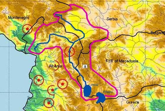
DRIN/DRIM RIVER Sub-basin
(sub-basin shared by Albania, FYR Macedonia and Serbia & Montenegro) |
The Drin river system is the largest river of Albania and collects water from the Adriatic portion of the Kosovo watershed in Serbia & Montenegro (as Beli Drin river) and in the south from the border region with FYR Macedonia (Lake Prespa / Lake Ohrid drains into Crn Drim river); its total basin encompasses about 14,173 km² (without both lakes).
The Drin River (285 km) is the most constant river of Albania: Fed by melting snows from the northern and eastern mountains (mean elevation at 971 m asl.) and by more evenly distributed seasonal precipitation, its flow does not have the extremely varying characteristics of nearly all other Albanian rivers.
The mouth of Drin river into the Adriatic Sea is located south of Shkodra near the city of Lezha but most of its water runs through an arm into Buna river near Shkodra.
Beli Drin / Drini Bardhe Sub-basin (Serbia & Montenegro / Albania)
Along its length of about 136 km, the “White Drin” drains a karstic region of nearly 4,964 km² within Albania and 4,360 km² in S&M (Kosovo) at a mean elevation 862 m.
Municipal and industrial pollution is coming from various towns like Pec (120,000 inhabitants 1991), Prizren (80,000 inhabitants 1998), Dakovica, and Orahovac.
There is no wastewater treatment in Albania and the sewage in discharged in rivers in uncontrol-led manner. This causes various pollution problems. Flooding of the plain of Drin river is another frequent problem especially in the winter period (increased by deforestation of the mountains) for the Shkodra and Lezha municipalities.
Crn Drim / Crn Drini River Sub-basin (FYR Macedonia / Albania)
The “Black Drin” river sub-basin drains lake Ohrid (controlled outflow since 1962) and flows north into the Adriatic Sea (mean elevation 1,152 m). It crosses near Debar the border to Albania and continues as Drini i Zi river (5,885 km² and 121 km long in Albania). It covers 3,840 km2 (excluding lake Prespa and lake Ohrid) of FYR Macedonia, at an average elevation of 1,100 m and with a total annual discharge of 1,502million m³. Two large reservoirs (Globochica and Spilje) have been constructed in this river basin on FYROM side, another 4 dams and 3 reservoirs (Fierze, Koman and Zadeje) at the lower Drim in Albania – all with the main purpose of hydroelectric power (providing over 90% of Albanian electricity).
The Drini waters join in the main arm with Buna river (effluent of lake Skadar) near the city of Shkodra.
|
1.1. Geographical Properties |
Longitude/latitude at downstream river outlet |
Albania |
Serbia & Montenegro |
FYR Macedonia |
Drini (Bahcallek)
42º 02’, 19º 30’
|
Beli Drim |
Outflow Crn Drim from lake Ohrid at Struga: 41º 10' 26“ / 20º 41' 0“ |
|
Size of basin |
14,173 km² (5,973 km² are on Albanian territory) |
4,360 km² |
3,840 km² (excluding Ohrid and Prespa lakes) |
Length and width in km |
| 285 km (on ALB territory) |
60 x 72 km |
|
Topography, including altitude range in m |
| Altitude: 0 m to 2,500 m |
280-2,656 m a.s.l |
At Ohrid lake: 693 m asl |
Geology |
| Limestone formation, accom-panied by karst phenomena in some parts of th eriver |
Beli Drim: Mainly lake and marine clastic incoherent rocks from Neogene (sands and weakly coherent sandstones).
Less: fluvial and fluvial-lake clastic incoherent quarternary rocks (gravels, sandy-gravels)
|
A complex of Paleozoic metamorphic and mag-matic rocks makes up the foundation bedrock of the entire western Macedonian zone (see also ch. 3.17 Lake Ohrid!). |
Rainfall, average annual and seasonal distribution, etc. |
Average annual rainfall
Eastern part: 934 mm
Valbona zone: 1,543 mm
Western part: 2,239 mm
Seasonal distribution
Winter Spring Summer Autumn
E: 360mm 240mm 120mm 214mm
V:524mm 365mm 184mm 470mm
W:734mm 530mm 240mm 735mm
|
600 - 1,500 mm
in average over 1,000 mm
|
The average annual preci-pitation for Ohrid is 703.1 mm (maxima in November, minima in July and August). For Struga the average annual precipita-tion is 793.9 mm. The bigest average annual pre-cipitation in the region was registered in Radolista: 1,048 mm. |
River(s), with lengths and average annual flows and seasonal distribution – flood and drought incidence and impact |
Drin River: Qavg: 350 m³/s
Reservoir Capacity: 2,700 M m³; Length: 285 km
Black Drin River: Qavg: 116 m³/s; Length: ca. 120 km
White Drin River: Qavg: 66.4 m³/s; Length: ca. 16 km
|
Beli Drim:
L: ca. 120 km
Qave = 57.1 m³/s
Qmin, mean, monthly: 13 m³/s
Qmax, mean, monthly: 89 m³/s
|
Crn Drim: ca. 50 km |
1.2. Demographic Properties
|
General location of the basin
|
Albania |
Serbia & Montenegro |
FYR Macedonia |
Drini basin is situated in the Nord –Eastern part of ALB |
South-western part of the Rep. of Serbia (Province Kosovo) |
Western part of the FYR Macedonia |
Total population in basin
|
289,255 inhabitants |
Data available at UN Interim Administration UNMIK (census 2002) |
Six municipalities in the Ohrid Lake catchment (Ohrid, Struga, Belcista, Meseista, Kosel and Resen) with 115.000 inh. (census 2002) |
Population of principal cities or towns
|
Peshkopi: 104,782
Kukes: 40,236
Tropoje: 42,116
Shkoder: 196,431
|
Pec, Prizren, Djakovica with 50.000-100.000 inh. (acc. to ICPDR). Data available at UNMIK (census 2002) |
Census 2002:
Ohrid 54,839 inh.
Struga 37,017 inh.
Resen 16,825 inh.
|
Average per capita income |
512.8 US$/year |
Available at UNMIK (for 2002) |
$ 6,700 (2003 est.) |
Industrial and agricultural GDP (Gross Domestic Product) (2003) |
16.13 billion $ (estim. 2003) |
Available at UNMIK (for 2002) |
Agriculture: 9.9% ; Industry: 25.3%
Services: 64.8% (2003 est)
|
Population living below the poverty line |
30% (estimated in 2001) |
Available at UNMIK (for 2002) |
30.2% (2002 est.). Very high unemployment rate |
Other relevant characteristics |
| Albania is a country in transition |
Before 1999. Albanian population in Province of Kosovo did not fully participate in censuses |
|
1.3 Land Uses |
The main land uses include park land and protected fauna/flora areas, skiing, forestry, grazing, dry and irrigated agriculture, hydro-electricity, urban and scattered industry, fish farming in ponds and coastal tourism |
30% Forests
44% Agriculture
18% Pastures
Other: not classified
|
|
2. WATER RESOURCES / USES AND ENVIRONMENTAL SITUATION
|
2.1. Total available surface and groundwater resources |
? |
Est. 1991:
Groundwater: 4,441 l/s
Surface waters: Qave = 62.2 m3/s; Qmin = 3.3 m3/s
|
|
Net usable capacity of surface reservoirs
|
Storage volume of 3,730 106 m3 (capacity of Fierza reser-voir: 2,7 million m³ = ca. 25% of annual flow) |
Radonjic: 113 mil.m3 |
Two large dams Globocica and Spilje with a usable capacity of 50 m3/s (42 MW) resp. 90 m3/s (70,2 MW) exist on Crn Drim |
|
Total surface water abstractions (estimated where nt measured) |
Discharge vol.: 11.1 km³/y
Specific discharge: 24.8 l/s.km²
|
6.3 mil. m³/y |
Crn Drim is the out-flow of Lake Ohrid (aver. dischar-ge: 22 m³/s, total annual outflow: 693.8 million m³) |
Total groundwater abstractions (estimated where not measured) |
Less than 10 m³/sec |
1,405 l/s (est. 1991) |
Less than 10 m³/sec |
Surface and groundwater quality (in general categories only) |
Chemical analyses of samples taken from the Drini showed a good water quality, with stable mineral composition along the river course. Metallic ions are present in small amounts except for iron in some cases.
The quality of groundwater is generally good; the springs yielded a fairly stable amount of water with low hardness (5 to 8 German degrees mostly).
|
Chemical analyses of samples taken from Beli Drim river showed a good water quality, with stable mineral composition along the river course.
The quality of groundwater is generally good
|
Ohrid Lake is considered as oligotrophic, with increased phosphorus and nitrogen concentrations |
Water uses (total, by sector, principal uses, current (estimated) and future (projected), include in-stream uses (fisheries, etc.) where appropriate) |
The water of Drini river is used for producing electricity. 3 big hydropower dams were built (Fierza, Komani, Vau I Dejes). |
Data may be available from UNMIK |
Main economic sectors are tourism and fishing
|
Deficits and other resource concerns (e.g. quality, extremes, environmental degradation) |
Floods |
Municipal and industrial waste-waters are discharged without any treatment;
Solid waste is disposed into dump sites which are often near the river banks.
|
The only environmental degradation in the region of Ohrid Lake on MAK side is agriculture and industry. Fertilizer use has declined over the last 10 years |
2.2 Environmental Properties
|
Sensitive ecosystems, biodiversity and environmental impacts in the basin
|
• Possible alteration of river bed
• Sewage and untreated wastewater
|
The Beli river basin is over-populated and sanitation is underdeveloped. Most environmental issues are related to this particular situation.
|
Tourism in the Ohrid area is very active.
The most important issues are solid waste and waste-water management.
|
3. BASELINE INFORMATION AVAILABILITY
|
Observation networks |
Albania |
Serbia & Montenegro |
FYR Macedonia |
18 hydrometric gauging stations installed in the basin |
Surface water: 17 gauging stations; Groundwater: 8 gauging stations |
Observation networks exists for surface and groundwater
|
Maps, with available scales, GIS and remote sensing imagery
|
Watershed Map, 1: 800,000
Maps 1:50 000 (Albanian, English)
Geologic-enginer. map of Albania: 1: 200 000
GIS Map (ARC/INFO)
Hydrological map 1:100,000
|
Some data available at:
Groundwater:
http://www.hidmet.sr.gov.yu
ciril/hidrologija/podzemne/13NP.html
Surface waters:
http://www.hidmet.sr.gov.yu/ciril/
hidrologija/povrsinske/hrs_pristina.html
|
Topographical maps 1:25,000; 1:50,000 (+GIS DTM from maps 1:25,000).
Geological 1:200,000.
Hydrogeologic.: 1:200,000 (under prepar. 1:25,000).
Agriculture (cadaster): 1:5,000
|
|
Data archives and their adequacy |
• Hydrologic and meteorolo-gic data are available for the basin for the last 30 years.
• Data are not publicly avai-lable but accessible via national agencies.
|
Data are not publicly available but accessible via the Republican Water & Weather Bureau (period before 1998).
Since 1999. data may be available at UNMIK.
|
No permanent measurement of surface water streams: Data are limited to short-term studies.
Monitoring data for all major meteorology. para-meters and water level exists since 1951
Data archives exist in relevant gvmt. and research institutions
|
Research centers |
National river-monitoring network of the Hydrometeorolo-gical Institute |
Water & Weather Bureau of the Republic of Serbia
http://www.hidmet.sr.gov.yu
|
Hydrometeorolog. Service (HMS), under the Ministry of Agriculture.
Hydrobiol. Institute in Ohrid
|
NAME AND CONTACT DETAILS OF PERSON(S) COMPLETING THIS FORM |
Msc. Emirjeta Adhami
Hydrometeorol. Institute, Dep. of Environment
Street e Durresit, No. 219
Tirana, Albania
Tel:(+355)(4)223518/222439
Fax: (+355)(4) 22 35 18
Email thadhami@icc-al.org
|
Prof. Dejan Ljubisavljevic
Faculty of Civil Engineering, University of Belgrade
Bulevar kralja Aleksandra 73
11000 Beograd, Serbia & Montenegro
tel: (381) 11 32 18 558
e-mail: ljubisav@grf.bg.ac.yu
|
Prof. Cvetanka Popovska
University of Ss. Cyril and Methodius, Faculty of Civil Engineering
Partizanski odredi bb, PO Box 560, 1000 Skopje
Tel: +389(2) 3116066/ext. 209; Fax: 3117367
popovska@gf.ukim.edu.mk
Vladimir Stavric, MSc
Ministry of Environment and Physical Planning, UNDP, NCSA Project Manager
Tel: +389(2)3061665
e-mail: vstavric@mt.net.mk
|
Serbia & Montenegro |
Albania |
FYR Macedonia |
| Buna/Bojana river is the outflow of lake Skadar/Shkodra and joins after only 300 m with river Drim, then continuing up to the sea as border river between S&M and ALB. For information on the Montenegrin part of river Bojana please see the summary table of lake Skadar. |
Crn Drini is the out-flow of lake Ohrid. Three hydropower dams impound it before it crosses the border to ALB. For infos on the section in FYR Macedonia please see chapter 3.17 for lake Ohrid! |
|
|
4.1. International agreements / conventions and national legislation |
|
The "Agreement between the Government of the People’s Republic of Yugoslavia and the Government of the People’s Republic of Albania" was signed in 1955 but is not in use since 1986.
The State Union of Serbia and Montenegro, and Albania have no bilateral agreement. The same applies for the State Union of Serbia and Montene-gro and FYR Macedonia.
|
|
The necessary legislation for sustainable water management in Kosovo & Metohija is largely missing: The former legislation for water management is not applicable to the present institutional arrangements.
In cases not covered by the constitutional framework for the self-government (UNMIK/REG/2001/19), the laws in force dealing with water after March 22, 1989 may be applicable. Consequently, legislation from the former Socialist Republic of YU, the succession Federal Republic of YU, and from S&M may apply. Due to these different origins, the body of law in the Drim catchment is extremely complex.
The most important law on water management in Kosovo is the Law on Waters from 1976, which covers the main aspects of water use and management but it is largely outdated and no longer applicable.
A new Water Law for Kosovo is currently under preparation with the assistance of US-AID. The law will establish clear responsibilities for the central government in Pristina and the River Basin Authorities. The establishment of River Basin Districts to decentralize water resources management is already official policy of the Kosovo Water Authorities. All ministries and agencies have agreed to follow this modern approach in water management.
A Water Master Plan was adopted in 1983 and approved for 20 years.
A draft Regulation on the Public Water Supply System was finalized in June 2002. This will regulate all public utility service providers of water, with specifics for the sale, quality, and reliability of drinking and irrigation water and wastewater. This regulation along with the new Water Law will set the new legal framework of water activities in Kosovo. A strategy for irrigation is needed as well.
A first environmental law for the Kosovo has been promulgated in 2003 and obliges the Kosovo Ministry of Environment and Spatial Planning to prepare a proposal for an Environmental and Sustai-nable Development Strategy.
The Public Utilities Regulatory Commis-sion in the Kosovo (PURCK) has been transformed into the Water and Waste Regulatory Office (WWRO) that is func-tioning within UNMIK Pillar IV.
|
Convention on the Protection and Use of transboundary rivers and lakes, Helsinki [1992]
National legislation and documents:
• Decision of Ministers' Council for pollution control (1974)
• Law for Environment Protection (1993, rev. 2002)
• Law for Resources Manage-ment (1996; revised In 2000)
• Law for the Protection of Transboundary Lakes (lakes Ohrid, Prespa and Shkodra; 2003)
• National Water Strategy (2004)
• Agreement on Water Economy with Montenegro (2003)
|
|
|
4.2. Institutions / distribution of responsibilities |
The Province of Kosovo & Metohia is presently not under the jurisdiction of S&M. Until very recently, no central water authority was operational in the Kosovo. The former Hydro- Economics Directorate, that concentrated all responsibilities for water resources management, ceased to exist before the conflict. In March 2002, the Kosovo Ministry of Environment and Spatial Planning (MESP) was established and was given the responsibility for all water resource management responsibilities. Sectoral responsibilities have been split between MESP (in charge of water policies, water monitoring and protection), the Ministry of Agriculture, Forestry and Rural Development (irrigation), the Ministry of Health (monitoring and protection of drinking water quality), the Kosovo Trust Agency (municipal administration), and the Public Utilities Regulatory Commission.
The 34 public water utilities in the Kosovo are under the administration of this agency, which plans to consolidate the water enterprises by reducing their number to four regional river-basin utilities to improve efficiency and cost-effectiveness. The Agency ‘s responsibi-lities are still not well defined and developed (e.g. creation of a database of water users and discharges and subsequent licensing arrangements; re-establishment of the hydrometric network). To begin, the MESP has created in August 2002 a Water Management Board to coordinate inter-Ministerial activities and to develop concerted approaches to water resource management.
Before the conflict, the Hydro-Meteorological Institute (HMI) was responsible for meteorological and hydrological monitoring but monitoring ceased when the network was destroyed in 1998. The European Agency for Reconstruction has recently started a project to rehabili-tate the hydrometric network and meteo-rological stations.
The Water Management Division within the Department for Environmental Protection of the Kosovo was newly created to cover all water related issues. |
The responsible institutions are:
• National Water Council (headed by the Prime Minister; includes Ministries for Tourism, Foreign Affairs, Energy, Agriculture, Health and Environment plus Academy of Sciences and the Technical Secretariat for Water)
• Subordinated are 6 river River Basin Councils (mana-ged by the related Prefectures) with Water Agencies as executive bodies
• For all transboundary waters, a government commission established specific sub-commissions for the neigh-boring countries.
• The Hydrometeorological Institute monitors all surface waters (quality and quantity)
• The Environmental Inspectorates control overall environment protection of waters and air
• Public Health Institutes monitor drinking water.
|
|
4.3. Planning / Decision-making processes
|
| Common planning and decision-making in the basin is poor although considerable efforts on problem definition are undertaken. |
The National Water Council organizes and decides on all water management issues. It can take specific initiatives (e.g. in 2004 to assess impacts of gravel excavation).
The sub-ordinated River Basin Councils decide on the regional water use (allocation and tariffs).
The complex water problems are partly not clearly sorted out in the new laws (overlapping of tasks).
For transboundary waters, no bilateral meeting was held yet due to the lack of a respective Agreement (Greece: negotia-tions started in 2003; SCG-Kosovo: only initial contacts).
|
|
|
4.4. Finances |
| There are no investment policies nor management plans that policies would follow. Donor co-financing has been secured for some priorities. |
• Government of Albania: 602 million USD
• KESH (Albania Electro-Ener-getic Corporat.): 1 mio. EUR
|
|
Serbia & Montenegro |
Albania |
FYR Macedonia |
4.5. Past and present major projects (including listing of donor interests)
|
| With the support of the Regional Environmental Center (REC), a new project is being prepared for the Drin River entitled "Drin River Watershed and Erosion Master Plan," to be implemented by Albania, Serbia and Montenegro and FYR Macedonia. |
• Construction of the HC Vau-Dejes hydrodam: 86 million USD (52 million for mounting and construction and 34 mio. for devices and equipment).
• Construction of Fierza Hydro-power dam: 286 million USD (172 million for mounting and construction and 114 million for devices and equipment).
• Construction of HC Koman dam: 230 million USD (138 million for mounting and con-struction and 92 million for devices and equipment).
(figures estimated by the USD-Leke exchange rates of that period, i.e. before 1985).
• “Establishing the monitoring network of Drini River: suppor-ted by KESH (Albania Electro-Energetic Corporation ) with 1 million EUR
|
|
|
4.6. Stakeholder Participation |
| NGOs have small relevance and impact due to their lack of experience and financial means. |
The biggest stakeholders in the region are the prefecture, the municipalities, the regional environmental inspectorate, the university of Shkodra, and NGOs |
|
4.7. Awareness / Communication
|
• Education plan and programmes for different school levels are under drafting. It is foreseen to incorporate water and environmental problems and sustainable development. Edu-cation outside of schools, espec. of interest groups (farmers, consumers etc.) does almost not exist.
• Education plan and programmes are not enough to deal with environmen-tal and water problems in a needed and critical manner.
• Public media do not closely follow up on water and environmental problems. They often approach them in an emotional way, therefore environmental awareness is not satisfactory.
|
Increasing local public aware-ness by organizing meetings via different NGOs as Ecological Club, PPNEA , etc. on the impact of Bushati hydrodam |
|
5. CONCLUSIONS / RECOMMENDATIONS |
5.1. Identification of critical problems (transboundary situation)
- problems related to the resource
- problems associated to uses, needs and demands
- problems affecting ecosystems
|
• The Kosovo has no system for flood protection. Part of the flood protection built in the past is not maintained (a flood in Nov. 1992 killed 11 people in ALB, damaged roads, bridges and irrigation networks, inundated 17,000 ha of agricultural land, damaged 1,330 and destroyed 216 houses, and damaged the Fierza hydroelectric facility).
• Wastewater treatment facilities do not exist, while some facilities for treat-ment of industrial waters do exist, but are out of order. This causes prob-lems with water quality, particularly during low water periods.
• Rehabilitation of old and building of new irrigation systems in the Beli Drim basin.
• Problems with drinking water supply in urban areas are: old water supply network, water losses in the network, misuse of drinking water and illegal abstractions, non-payment of water bills and low level of awareness of citizens.
• Water transfer from the Beli Drim to the Ibar river Basin (in the Water Resources Master Plan of Serbia, the water supply of the future Kosovo thermal power plants was planned from the Beli Drim basin)
|
• A pending threat is the buil-ding of a new hydropower plant Bushat on the Drin river near Shkodra (upstream mouth of Buna river from the lake) which is supported by the Chinese government but does not find a majority among local politicians, scientists and local people.
• The frequency of flooding and the negative impacts of sediments deposition are on the increase.
• There is very significant sediment movements in the river, but the rate has not change drastically over the time.
• The most significant factor contributing to flooding and sedimentation is river instability, caused by gravel mining.
|
|
5.2. Main achievements |
| The political situation and the status of Kosovo and Metohija are still unstable and prevent significant progress in water management. |
Increased public awareness concerning decision-making |
|
5.3. Key challenges |
| The policy and institutional development of the water resource sector has moved forward in the past 3 years but imple-mentation and enforcement of environ-mental and water policies is limited. Although there is a consensus on priori-ties within the Kosovo environment ministry, a clearly structured integrated water resource management strategy could be useful. |
Secure priority investments on environment protection that will attract both bilateral and private investments. |
|
5.4. Donor interests |
| Donor co-financing has been secured for some priorities. |
Overall ability to mobilize domestic and private capital is not at the desired level. The government and local stakeholders are open for support and institutional development. |
|
5.5. Recommended priority actions |
• Approval of laws and regulations for water users and suppliers in harmony with EU laws and regulations.
• Monitoring of water quality and quantity.
• Drafting of plans for the management of water basins (integrated water management).
• Protection from pollution of surface and ground waters.
• Approval of strategic plans in emer-gency cases.
• Spreading of the water supply network and improvement of the water supply for citizens.
• Extension of the sewage system in urban and rural areas.
• Drafting of a Kosovo National Plan for construction of wastewater and indus-trial water treatment plants, and creation of suitable models for the treatment of polluted waters in urban and rural areas.
• Public awareness and education for the rational use of water resources.
|
• Modernization of the monitor-ring network
• Monitoring and studying of the complex water system (Shko-dra lake, Buna and Drini Rivers ) to prevent flooding like in November – December 2003.
• Solving the problems of land use and ownership
• Capacity building
• Raising awareness of the local population
|
|
6. MAIN REFERENCES, BACKGROUND DOCUMENTS |
| Data from The International Bank for Reconstruction and Development/The World Bank Report, Environmental Strategy and Sustainable Development for Kosovo - draft, Internet, private data |
Hydrometeorological Institute
Secretariat of the National Water Council: National Water Strategy for Albania – Final report, BCEOM French Engineering Consultants, 1996
Ministry of Environment: Directory of Pollution Prevention
Albania Electro-Energetic Corporation: Monitoring Network in Drini River 2001 – 2003
|
|
|