Internationally Shared Surface Water Bodies in the Balkan Region |
|
Data for the basin was compiled in cooperation with Zinke Environment Counsuting (2004)
|
| Transboundary River Sub-basins
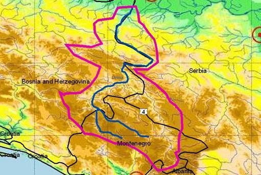
Drina River Sub-basin
|
| 1. |
GENERAL INFORMATION |
DRINA RIVER
(sub-basin shared by Bosnia& Herzegovina and Serbia & Montenegro) |
The Drina river basin encircles the central part of the Dinaric mountains, including a very small part in Albania and ending in the Pannonian plain. The river basin covers 19,946 km² (in BiH 7,240 km2 and a river length of 346 km; 17,493 km² and 220 km in S&M) of mostly mountain terrain. The average altitude is 945 m asl. (springs of the Piva and Tara source rivers of the Drina are in Montenegro, mouth into the Sava river at 74.4 m), the discharge at the mouth is 371 m3/sec (largest tributary of the Sava). Drina river itself starts at the border of BiH and S&M (confluence of Piva and Tara rivers). It forms for most of its course the border between these two states and is known for its excellent water quality (Tara canyon is also a 19,200 ha large national park). The main right tributaries are Ćehotina, Lim, Uvac, Rzav and Jadar, the left tributaries Sutjeska, Prača and Dranjača.
Drina has very torrential character in its upper catchment (the erosion and flood risks are limited by 771 km of dikes). The basin is most important in B&H due to its energy supply: A total of 97 small and large hydro-energetic plants are registered, including 6 plants under construction. The total technically used hydro-potential is 1,838.6 MW, the annual production before the war was 7,107.66 GWh.
The Drina river basin encircles the central part of the Dinaric mountains, including a very small
Lim river is the major tributary of Drina with a transboundary sub-catchment of 3,160 km² (2,660 km² in S&M). It has its source in eastern Montenegro (Prokletije mountains at the Albanian border) and flows through the small towns Ivangrad, Bijelopolje and Priboj (36,000 inhabitants; at border to BiH). The Lim is subject to serious exploitation of riparian vegetation and sand/gravel excavation and is impounded by several dams.
The planned hydro-system "Rzav-Uvac-Lim" aims at transferring water (about 40 m³/s) from the Drina River catchment towards the Morava drainage and facilitating a multipurpose water supply scheme in the Central Serbia (irrigation, drinking water supply, low flow augmentation, industrial supply, etc.).
The Drina catchment has a low population density, a high biodiversity and very good water quality. There are various national parks and strict nature reserves with relict and endemic species, glacial lakes and canyons. Tourism and recreation are important activities.
Most pollution comes from the municipalities Gorazde (upper Drina: 39,000 inhabitants in 1998) and Bijeljina (lower Drina: 37,000 inhabitants in 1991), which is also the site of a big pig farm. Transboundary impacts exist in form of altered flow rates due to reservoir operation, intensive forestry (including wood and paper industry) and accidental pollution (petrochemical and metallurgy industry) as well as from intensive agriculture in the lowest section.
|
|
Bosnia and Herzegovina |
Serbia and Montenegro |
1.1. Geographical properties |
Longitude/latitude at downstream river outlet |
X 6608424.372, Y 4971582.166 |
? |
Size of basin |
| Area of the river basin in B&H: 7,240 km ² (37% of the catchment: the greatest part to the Republic of Srpska). |
Drina River is the greatest and the most important tributary of the Sava. The greatest part of its catchment (62%) is situated on the territory of the S&M (Rep. of Montenegro: 31,5%, Rep. of Serbia: 30,5 %), and less than 1% to Albania. However, 2/3 of the total discharge at the river mouth, originates from Montenegro.
At monitoring station Badovinci (16 km from the river mouth): 19.485,0 km² |
Length and width in km |
| Length of river in B&H: 346 km / 78 km |
Length bordering Serbia&Montenegro: 220 km |
Topography, including altitude range in m |
Average watershed slope: 945 m
Altitude at the mouth into Sava: 74.4 m a.s.l
|
Geology |
| Upper Drina watershed: Massive, thin bedding and bedding limestone, dolomitised and sandy limestone, rarely dolomites.
Middle Drina watershed: Igneous rocks, serpentinites, sandstones, locally sandy and marl limestone.
Lower Drina watershed: Gravel, sandy gravel and gravelly sands
|
Upper Drina watershed: Massive, thin bedding and bedding limestone, dolomitised and sandy limestone, rarely dolomites, and purely reef organic limestone; Marls and shales from Neogene, Cretaceous flysch diabase-chert formation and schists.
Middle Drina watershed: Igneous rocks, serpentinites, sandstones, locally sandy and marl limestone
Lower Drina watershed: Gravels, sandy gravels and gavelly sands, sporadic sands. |
Rainfall, average annual and seasonal distribution, etc. |
| Mean annual precipitation:
900 -1,100 mm/y (tendency to decrease in downstream direction)
|
Mean annual precipitation:
Upper and middle Drina watershed: 800-1,500 mm
Lower Drina watershed: 600-800 mm
Continental regime of precipitation, with the larger quantities of precipitation occurring in May and in June (then 12-13% of total annual precipitation). The lowest precipitation occurs in February or October (in average 5-6% of total annual precipitation).
The region of south-western Serbia is characterised by a Mediterranean regime of precipitation (maximum in November to January and minimum in August). |
River(s), with lengths and average annual flows and seasonal distribution - flood and drought incidence and impact |
Name Catchment's area Average flow at mouth
Drinjača 435 km² 6.54 m³/s
Lim 4,024 km² 113 m³/s
Čehotina 732 km² 16.0 m³/s |
Montenegro:
Piva: 1,784 km²
Tara: 2,040 km² / 149 km/ Q (at Djurdjevica Tara station): Qmin = 4.4 m³/s Qmax=980 m³/s
Serbia: Jadar 959 km²
|
1.2. Demographic properties |
General location of the basin |
| The Drina river basin encircles the central part of the Dinaric Mountains. Drina starts at the border of B&H with Serbia&Montenegro at the confluence of Piva and Tara rivers. It forms for most of its course the border between these two states. |
Total population in basin |
| There is no exact data but the Drina river basin in B&H has a low population density. |
No exact data available. Population is mainly situated in towns and larger settlements (listed below). |
Population of principal cities or towns |
Goražde 31,582 (estimation)
Višegrad:
Zvornik
Bijeljina
|
Montenegro: Andrijevica (6,696), Bijelo polje (55,628), Pljevlja (39,593), Mojkovac (10,830), Kolašin (11,120)
Serbia: Bajina Bašta (29,747), Loznica (86,875) |
Average per capita income |
USD 1,800 (est. 2001) |
est. 2,200 $/capita |
Industrial and agricultural GDP (Gross Domestic Product) |
1263 USD (estimation, 2001) |
Industry: 28.2%
Agriculture: 15.2%
Services: 56.5 %
|
Population living below the poverty line |
Over 25% |
10-15% |
Other relevant characteristics |
N/A |
N/A |
1.3 LAND USES |
There are various national parks and strict nature reserves with relict and endemic species, glacial lakes and canyons. Tourism and recreation are important activities. |
Upper part of the basin (Montenegro): mainly forests; less agriculture (in the valley of the river Lim, tributary of Drina)
Middle part of the basin (Serbia): mainly orchards, vineyards, mix cultures.
Lower part of the basin (Serbia - Macva, near the river mouth): agriculture. |
Bosnia and Herzegovina |
Serbia and Montenegro |
2. WATER RESOURCES / USES AND ENVIRONMENT SITUATION |
Total available surface and groundwater resources |
Available surface water – Drina river:
Profile – Location Average flow (m³/s)
Foca 212
Visegrad 341
Popovi 422
Selected 20 groundwater sources:
total minQd (l/s) = 3,700
|
No exact information for the Drina available.
Total in central Serbia: surface water 212 mil. m3/year, groundwater 460 m³/year.
For Montenegro, information not available
|
Net usable capacity of surface reservoirs |
Drina river:
Reservoir Visegrad: Vol.= 105 hm³
Reservoir Bajina Basta: Vol.: 218* hm³
Reservoir Zvornik: Vol.: 18 * hm³
*: Reservoirs shared between BIH (RS) + SCG
|
Drina river basin in Serbia: 959 mil. m³
Drina river basin in Montenegro: 800 mil. m³ in the artificial reservoir Piva
|
Total surface water abstractions (estimated where not measured) |
? |
Exact information for the Drina river basin could not be obtained.
Central Serbia: 405.8 mil. m³/year
Montenegro: information could not be obtained |
Total groundwater abstractions (estimated where not measured) |
FBIH: 18.064 m³/d
RS: 36.166 m³/d
|
No exact information for the Drina available.
Central Serbia: 125.3 mil. m³/year
Montenegro: information could not be obtained
|
Surface and groundwater quality (in general categories only) |
Classified in class II
From profile Foca to profile Popovi
Remark: Decree on the Classification of Waters of the Inter-Republic Watercourses, Inter-State Waters and Coastal Sea Waters (Federal Government Gazette, No. 6/78)
|
Montenegro:
2/3 of the total discharge at the mouth of the Drina originates from the northern highlands of Montenegro, from the Piva and Tara water-sheds. Water quality in these rivers is of first class which makes them unique and famous.
Water quality of the rivers Ćehotina and Lim is of 2nd class downstream of larger settlements, due to increase of BOD5, suspended solids and PAHs.
Serbia:
Drina: according to oxygen parameters, nutrients and heavy metals, Drina is classified in the 2nd class (2003. annual report of the Republican Weather Bureau).
Note: classification of surface water is according to the Decree on the Classification of Waters of the Inter-Republic Watercourses, Inter-State Waters and Coastal Sea Waters (Federal Government Gazette, No. 6/78) |
Water uses (total, by sector, principal uses, current (estimated) and future (projected), include in-stream uses (fisheries, etc.) where appropriate) |
97 small and large hydro-energy plants are registered, including 6 plants under construction. The total technically used hydro-potential is 1,838.6 MW, the annual production before the war was 7,107.66 GWh. |
Current: Water supply: 30%, Industry: 62%, Irrigation: 8%.
Future (2010): water supply 209 mil. m3 (12.2% of total for SCG), industrial water supply 530 mil. m3 (75% of total for SCG)
Note: figures above refer to Sava river basin including the Drina river basin. More precise data are currently not available. |
Deficits and other resource concerns (e.g. quality, extremes, environmental degradation) |
| Urban and industrial wastewater treatment is missing, as well as adequate solid waste landfills. |
• Untreated industrial wastewater from the industrial centers on the banks of Drina
• On the banks of Drina, there is a great number of trash dumps which contains solid municipal waste and, not rarely, industrial waste |
ENVIRONMENTAL PROPERTIES |
Sensitive ecosystems, biodiversity and environmental impacts in the basin |
• About 80% of people in B&H live in urban settlements, only about 50% are connected to public water supply and 35% to sewerage systems. 90% of the urban sewage is directly discharged into the water courses.
• Main pollution problem is sewage and un-treated wastewater from municipalities and industries. However, since the end of war only few factories (mostly without treatment plants) produce again. Most pollution comes from the municipalities Gorazde (upper Drina) and Bijeljina (lower Drina), which is also the site of a big pig farm.
• Transboundary impacts exist in form of altered flow rates due to reservoir operation, intensive forestry (including wood and paper industry) and accidental pollution (petroche-mical and metallurgy industry) as well as from intensive agriculture in the lowest part.
|
? |
3. BASELINE INFORMATION AVAILABILITY |
Observation networks |
Bosnia and Herzegovina |
Serbia and Montenegro |
• Federal Meteorological Institute implements monitoring on the territory of FB&H, while Hydro-meteorological Institute of Republic of Srpska does that in Republic of Srpska.
• Public companies for Watershed Areas organize monitoring of water courses regime
|
In accordance with legal powers and responsi-bilities, quality control of surface waters of inter-state and inter-republican watercourses, as well as watercourses intersected by the state border, the control of other watercourses is performed by the relevant Republican Weather Bureaus: of Rep. of Serbia and of Rep. of Montenegro. |
Maps, with available scales, GIS and remote sensing imagery |
GIS-based information system for the water sector (management) is missing. |
Maps of the surface and groundwater monito-ring network with other details are available at http://www.hidmet.sr.gov.yu/ (official url address of the Serbian Water Bureau) and http://www.meteo.cg.yu/ (Water Bureau of the Rep. of Montenegro). Also attached within the previous inventory. |
Data archives and their adequacy |
• Unclearness in legal articles, institutional, human resources and financial problems in the sector resulted, among others, in insufficiently developed, not-harmonized and non-systematic monitoring
• BiH sent data on river water quality in the year 2000 to EUROWATERNET (ETC/W) for the first time at the end of 2001 (36 monitoring stations)
• Information on physical characteristics and on the State/Quality of Water of Drina River (stations: Srbinie, Cehotina mouth, Lim mouth, Badovinci)
|
Serbia:
All registered data are collected in the Bureau's regional centers in: Nis, Kraljevo, Valjevo, Novi Sad (central), Pozarevac, Beograd (central), and Pristina. After processing, they are stored in the Hydrologic Informational System Database.
Serbian Water Bureau is the only official institution authorised for the hydrology data collection and processing.
Montenegro: ? |
Research centres |
• Federal Meteorological Institute
• Hydro-meteorological Institute of Republic of Srpska
• Public companies for Watershed Areas
|
Water and Weather Bureau of the Republic of Serbia:
local center: Valjevo
central office: Belgrade |
NAME AND CONTACT DETAILS OF PERSON(S) COMPLETING THIS FORM |
Prof. Tarik Kupusovic
Hydro-engineering Institute Sarajevo
Stjepana Tomica 1
71 000 Sarajevo, Bosnia and Herzegovina
Tel/fax:+ 387 33 207 949
E-mail: tarik.kupusovic@heis.com.ba
heis@heis.com.ba
URL: www.heis.com.ba
|
Prof. dr Dejan Ljubisavljeviζ
Fac. of Civil Engineering, Univ. of Belgrade, Dep. of Hydraulic and Environm. Engineering
Bulevar kralja Aleksandra 73, 11000 Beograd
Serbia and Montenegro
e-mail: ljubisav@grf.bg.ac.yu
tel: (+381) 11 3218 557; Fax: (+381) 11 3370 223
Branislava Jovanoviζ, MSc CE (same address) |
Serbia and Montenegro |
Bosnia and Herzegovina |
4. MANAGEMENT SETTING |
4.1. International agreements / conventions and national legislation |
Danube River Protection Convention (1994)
In FPR Yugoslavia, there were several agreements between its republics (Serbia, Montenegro, Bosnia and Herzegovina) regarding Drina river basin management, mainly concerning the use of the hydropower potential.
At this moment there is no bilateral agreement between Serbia & Montenegro and Bosnia & Herzegovina.
An agreement between the FPR of Yugoslavia and Albania concerning water management issues (in force since 1956) was partly successfully implemented (in managing water resources forming or crossing the border) but cooperation was discontinued in 1986. There is a need for a new agreement, but preparations have not been started yet (little political interest because Albania covers less than 1% of the Drina basin).
Parts of the Drina basin are protected by international conventions: UNESCO–world natural and cultural heritage - National park “Durmitor” (1980), UNESCO-MAB - Tara river basin (1977).
Principal focus themes are:
• Integrated water resources management
• Hydro power utilization
• Water quality control
• Flooding control
• Irrigation.
|
| Serbia is preparing a proposal for a compre-hensive bilateral agreement that should be finished in 2004. |
Since 1996 BiH is actively involved in the work of expert teams of the Danube River Protection Convention (representatives in the ICPDR and the expert groups AEW, MLIM, EMIS, ECO etc.). At the moment procedure for adopting BiH, as regular member is in process (the Ministry for Urbanism, Civil Engineering and Ecology of Republic of Srpska is the national focal point and reference center for coordination and implementation ). |
4.2. Institutions / distribution of responsibilities |
At the State Union of Serbia and Montenegro there is no body responsible for water resour-ces management.
In Serbia responsibility for water resources management is mainly with the Ministry for Agriculture, Forestry and Water Management (Directorate for Water). In Montenegro, responsibility is with the Ministry of Agriculture (section for water management).
|
In both Federation of BiH and RS the agency with primary responsibility for the water sector is within their respective Ministry of Agriculture, Water management and Forestry (MoAWF). Within MoAWF, each entity has a Department of Water Management (in RS it is the Directorate for Water) responsible for the water strategy and policy, the issuing of agreements and permits, setting of standards and regulations; ensuring compliance with laws and regulations through licensing and inspections; and overall control of Public Companies for Watershed Areas. |
4.3. Planning / Decision making processes |
Several planning documents for the Drina river basin of the FPR of Yugoslavia are now outdated. Today, a master plan for the basin does not exist.
There are officially adopted general water master plans for Serbia (2002) and Monte-negro (2001), that also cover this basin, but they do not go into details.
Institutional arrangements do not exist, and all decision-making processes are separated to each country. Joint planning and decision-making in the basin is poor, although conside-rable efforts on problem definition are undertaken.
Electric Power Industry of Serbia (EPS) and other electric power companies, together with water management bodies in all entities are trying to establish a hydro-information system for the Drina (still in preparation).
|
Under the Water law (1998), in the Federation of BiH the MoAWF delegates the main responsibility of preparation of strategic decision and planning to two Public Companies of Water-shed Areas, one for the River Sava and the other the Adriatic Sea. Republic of Srpska has only single authority in charge for both main river basin districts.
The new Law on Water Protection, based on EU WFD, calls for a river basin approach in water administration and establishes new bodies responsible for water protection based on river basins. |
4.4. Finances |
| There are no investment policies nor management plans at the moment. |
According to the Water Law (1998), Article 168, financing of water management is based on the following principles:
• Resources for financing water management are provided from general water fees, special water management fees, fees from conces-sions and funds provided by special law, as well as from other resources defined by this law;
• General water fees; special water manage-ment fees and fees from concessions are to be used for all beneficiaries on the territory of the Federation and/or main watershed areas, unless otherwise defined. |
4.5. Past and present major projects (including listing of donors’ interest) |
Serbia and Montenegro |
Bosnia and Herzegovina |
Major project in the Drina river basin is the Buk Bijela hydropower plant. Tender docu-menttation about this project was finished before 1990. Stopped due to the war, this project now is again in a tender procedure. According to an agreement between the former republics, 2/3 of its potential belong to BiH, and 1/3 to Montenegro.
The Municipality of Bajina Basta with the REC offices in Serbia and BiH started in 2003 a project to protect Perucac lake from further pollution by solid waste and to start its cleaning (Norway is interested to fund it).
|
EC (CARDS 2002) - Development of a national environmental monitoring system (started in September 2003). |
4.6. Stakeholder Participation |
| Stakeholder participation in the Drina river basin is rather poor and under-developed. The most powerful groups are the electric power companies (EPS from Serbia, EPCG from Montenegro and EPRS from BIH-Rep. Srpska) |
Stakeholder participation in the Drina river basin is rather poor. Civil sector is still developing in BiH, but the NGO sector is a very active player in the environmental sector. |
4.7. Awareness / Communication |
At this moment the most positive role in awareness – raising and education is with the national TVs in Serbia, Montenegro and BiH with different contributions of journalists specialized on environmental problems and also documentary (scientific) programmes (domestic and foreign).
Environmental NGOs have an important role in raising awareness, but it is important to implement the recommendations of the EU-WFD in new Water Law and Environmental Law in Serbia and in Montenegro.
|
Bosnia and Herzegovina has not signed the Aarhus Convention, but the Entities have laws on access-to-information, as one way for its implementation.
At this moment the most positive role in awareness – raising and education is with different local and mass media.
|
5. CONCLUSIONS / RECOMMENDATIONS |
5.1. Identification of critical problems (transboundary situation)
- problems related to the resource
- problems associated to uses, needs and demands
- problems affecting ecosystems
|
Serbia and Montenegro |
Bosnia and Herzegovina |
The most critical problems are:
EPCG wants to transfer water from the Drina river basin (Tara River) to the Moraca river Basin (Adriatic watershed), which is not in accordance with plans in Serbia and BiH.
Serbia wants to transfer water from the Drina basin (Uvac and Lim rivers) to the Zapadna Morava Basin.
There are plans for building a huge reservoir Tepca on the Tara river on the territory of the National Park Durmitor, which would create major ecological problems.
Other plans for several cascade hydropower dams on the middle Drina reach would cause problems for local communities.
There are plans for several cascade hydro-power dams on the lower Drina, which would cause problems for countryside protection, water quality etc.
Other problems exist with the operation regime of the existing hydropower plants
There will be a future need for irrigation water in the lower Drina section.
|
The most critical problems are:
• Wastewater generated by 90% of the population is discharged directly without any treatment into the closest water bodies or into karstic holes, which are connected to groundwater;
• Water supply systems cannot meet the needs of the consumers during the dry season due to a combination of inadequate availability of water resources and inadequate capacity of the infrastructure;
• Dumping sites where the waste is disposed are mostly placed near the river, and in most cases are used without special protective measures;
|
5.2. Main achievements |
| |
The current reforms of the Water Sector in B&H.
Project entitled "River Basin Management Program", launched in November 2003, and to be finished in 2005. |
5.3. Key challenges |
• Realization of the Buk Bijela hydropower dams
• Realization of a Drina RBM Plan
• Capacity building of water authorities
• Involvement of the local community and stakeholders
• Mobilization of all kinds of capital for suitable economic projects.
• Building and executing a policy strategy for stakeholder participation.
|
• Establishment of a River Basin management approach
• Drafting secondary legislation
• Training of Staff of River Authorities
• Drafting an appropriate financing model
• Public participation strategy of River Auth.s for policy formulation, approval of policy documents and plans, implementation and monitoring
• Introduction of GIS
• Mapping of water bodies
• Developing internet page for each river basin |
5.4. Donor interests |
| The Drina river’s unused hydropower potential is still large and some of dam projects are very interesting for foreign donors – Buk Bijela, Tepca (provided that ecological problems could be solved) |
Donor interests will largely depend on concrete results obtained through water sector reforms in BiH |
5.5. Recommended priority actions |
• Reach agreement for water uses (electric power, water supply, water quality control, and irrigation).
• Preservation of protected areas.
• Further investigations in the basin (hydrogeology, hydrology, biology)
|
• Preparation of primary and secondary water-sector legislation
• Establishment of a new organizational set-up of the water sector for the main managerial levels (State, Entity and River Basin)
• Preparation of public participation programs;
• Human capacity building
• Preserve protected areas
• Investigations in the basin (hydrogeology, hydrology, biology) |
6. MAIN REFERENCES, BACKGROUND DOCUMENTS |
| Data from Serbian and Montenegrin Water Master Plans, Srbijavode, Internet, The Intl. Bank for Reconstruction and Development/-The World Bank Report, private sources. |
Data from HEIS documentation, Internet, private sources. |
|
| |
|
|
|
| |
|
|