| 1. |
GENERAL INFORMATION |
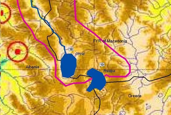
Lake OHRID Sub-basin
(sub-basin shared by FYR Macedonia and Albania) |
Ohrid Lake is the biggest lake of FYR Macedonia, with a total surface area of 348.8 km² (FYR Macedonian part 229.9 km²), a total catchment of 2,340 km² (including underground flow from lake Prespa), and a maximum depth of 285 m (average 164 m). It drains into Crn Drim river (regulated outflow in Struga at ca. 22 m³/sec, according to the needs of the river power plants). The main economic activities in this region are tourism (very important for FYR Macedonia and Albania) and fruit production. The population in the Ohrid and Struga municipalities is over 100,000; and including the people across the borders to Greece and Albania it amounted over the last decades to some 200,000 people.
Lake Ohrid is located at 695 m asl. and isolated by surrounding hills and mountains (exceeding 2,000 m). It is one of the oldest lakes world-wide (2-3 million years). Many of its plants and animals are endemic (e.g. 10 of its 17 fish species) or “living fossils”. Its reed belt is an important spawning place and a wintering site for birds. It is a very old cultural center of the Balkan and became a UNESCO World Heritage Site in 1980. Climate is both Mediterranean and continental, with more than 700 mm of annual precipitation.
Numerous pressures on fisheries (over-harvested), the littoral zones (losses in the native reed zone) and the oligotroph water quality (eutrophication and fecal contamination due to communes like Pogradec on Albanian side and agriculture; the FYR Macedonian Ohrid bay has a sewage collection) have started to alter the sensitive character and uniqueness of the lake. A yet not quantified problem is exerted from Albanian mine fields.
|
FYR MACEDONIA |
ALBANIA |
1.1. Geographical properties |
Longitude/latitude at downstream river outlet |
41º 15' N 20º 45' E
Outflow Crn Drim at Struga: 41º 10' 26“ / 20º 41' 0“ |
40,55º N 20,41º E |
Size of basin |
843 km2 (in FYR Macedonia)
The average depth of the lake is 164 m, and the maximum one is 289 m. The total length of the coastline is 87.5 km of which 56 km belongs to FYR Macedonia and 31.5 km to Albania. |
362.5 km2 (in Albania) |
Length and width in km |
The length of the lake surface is 29.5 km and the width varies from 11.2 to 14.7 km. |
Topography, including altitude range in m |
Average altitude: 693 m |
Geology |
A complex of Paleozoic metamorphic and mag-matic rocks makes up the foundation bedrock of the entire western FYR Macedonian zone.
The Mesozoic rocks from the Triassic Era show two types of faces: (a) sediments consisting of conglomerates, sands, clays and (b) carbonate sediments as slate, bank and massif limestone and dolomites. These sedimentary formations are intensely rugged, broken and karstified.
Tectonic forces formed much of the terrain in the Lake Ohrid watershed. It has been shaped by both hercynian and alpine orogenesis.
The total volume of infiltration is 474 mm. |
The water of Prespa Lake is drained to Ohrid Lake through the Mali Thate-Galichica karst massif.
The surface of the karst massif is of 350 km². The total volume of karst water coming out from Mali Thate and Galichica is of 5.2 m³/s. |
Rainfall, average annual and seasonal distribution, etc. |
The average annual precipitation for Ohrid is 703.1 mm, with maxima in November and minima in July and August. For Struga the average annual precipitation is 793.9 mm with maxima and minima in the same months. The bigest average annual precipitation in the region was registered in Radolista: 1,048 mm. |
Average annual rainfall: 897 mm
Seasonal distribution:
Winter Spring Summer Autumn
300 mm 205 mm 92 mm 300 mm |
River(s), with lengths and average annual flows and seasonal distribution - flood and drought incidence and impact |
The rivers flowing into Ohrid Lake are:
· Koselska (length of the river 32.2 km,
average long-term discharge 1.3 m³/s,
average basin elevation 1,070 m)
· Sateska (length of the river 39.8 km,
average long-term discharge 6.15 m³/s,
average basin elevation 1,111 m)
Total volume of the lake Ohrid: 50,7 billion m³ |
Total volume of the lake Ohrid: 50,7 billion m³ |
1.2. Demographic properties |
|
|
General location of the basin |
L. Ohrid is located in the western part of MAK |
Ohrid Lake is located in the eastern part of ALB |
Total population in basin |
Six municipalities in the Ohrid Lake catchment (Ohrid, Struga, Belcista, Meseista, Kosel and Resen) with 115.000 inh. (census 2002) |
73,930 inh. |
Population of principal cities or towns |
According to the census in 2002:
Ohrid 54,839 inh (15,526 households)
Struga 37,017 inh (8,908 households)
Resen 16,825 inh (4,849 households) |
Pogradeci (Albania): 73,930 |
Average per capita income |
Purchasing power parity - $ 6,700 (2003 est.)*
*CIA-The World Factboook http://www.cia.gov/cia/publications/factbook/geos/mk.html |
512.8 US$ / year |
Industrial and agricultural GDP (Gross Domestic Product) (2003) |
Agriculture: 9.9% ; Industry: 25.3%
Services: 64.8% (2003 est.)*
*CIA - The World Factboook http://www.cia.gov/cia/publications/factbook/geos/mk.html |
16.13 billion $ (estimated in 2003) |
Population living below the poverty line |
30.2% (2002 est.)*
*CIA - The World Factboook http://www.cia.gov/cia/publications/factbook/geos/mk.html
The unemployment rate is very high (in Ohrid over 25,000, in Struga over 20,000, in Belcista over 1,300). The country rate of unemployment is 40%. |
30% (estimated in 2001) |
Other relevant characteristics |
The industrial activities include alimentary, textile, metal and wood processing and other light industries. |
The major industry in the region include the production of automobile spare parts, metal and ceramic products, plastics, textiles, electrical parts (transformers, transmission equipment, etc..) and food. |
1.3 LAND USES |
Arable land: 53,303 ha
Pasture: 27,319 ha
Forests: 61,225 ha |
The main land uses include park land and protected fauna/flora areas, forestry, grazing, dry and irrigated agriculture, urban and scattered industry, fish farming and coastal tourism
Arable land: 2,500 ha
Pasture: 1,367 ha
Forest: 10,248 ha |
2. WATER RESOURCES / USES AND ENVIRONMENT SITUATION |
FYR MACEDONIA |
ALBANIA |
Total available surface and groundwater resources |
Total surface water inflows: 14.47 m³/s
Total groundwater inflows: 10.26 m³/s
The biggest quantity of the inflow water is coming from springs in the southern lake part. |
Average annual inflow of Cerava river: 1.5 m³/s
Average annual inflow of Pogradeci river: 0.25 m³/s
|
Inflow
106 m³ |
Outflow
106 m³ |
Surface flow
- Rivers
- watershed |
380.6
75.7 |
693.8 |
Underground flow
- Known sources
- Unknown sources |
323.6
?? |
|
Precipitation |
276.6 |
|
Evaporation |
|
408 |
TOTAL |
1056.5 |
1101.8 |
|
Net usable capacity of surface reservoirs |
In the catchment of Crn Drim two large dams Globocica and Spilje with a usable capacity of 50 m³/s (42 MW) resp. 90 m³/s (70,2 MW) exist |
In the catchment of Black Drin 3 hydropower plants are constructed with a total storage volume of 3,730 106 m3, from which 93% of country’s generation capacity is produced. |
Total surface water abstractions (estimated where not measured) |
The only outflow watercourse of Lake Ohrid is Crn Drim river with an average discharge of 22 m³/s, which sums up to a total annual outflow of 693.8 million m³ |
Total groundwater abstractions (estimated where not measured) |
Yields of springs, not abstractions:
St. Naum springs: average discharge 7.50 m³/s
Biljana springs: average discharge 0.26 m³/s |
Tushemishte spring: average discharge 2.5 m³/s |
Surface and groundwater quality (in general categories only) |
- Ohrid Lake has been considered as oligotrophic.
- The mean total phosphorus concentration measured in station 1 varied between 4.65 and 6.8 mg/L (period July 2000 to May 2001). In the same period the nitrogen concentration varied between 171 mg/L and 512 mg/L.
- Phosphorus and nitrogen concentrations in the lake have increased.
|
Water uses (total, by sector, principal uses, current (estimated) and future (projected), include in-stream uses (fisheries, etc.) where appropriate) |
Main economic sectors are tourism and fishing |
Fishing industry |
Deficits and other resource concerns (e.g. quality, extremes, environmental degradation) |
The only environmental degradation in the region of Ohrid Lake on FYR Macedonian side is agriculture and industry. Fertilizer use has declined over the last 10 years from 470 kg/ha/y on plowed fields to 180 kg/ha/y, and on the other fields from 390 kg/ha/y to 160 kg/ha/y. The use of pecticides has also decreased but specific figures are not available.
Industrial impacts are also significant. The major industries in the region include production of automobile spare parts, electrical parts, metal and ceramic processing, plastics, textiles, shoes. Almost all industries, except electricity and water management have been privatized. |
The condition of Lake Ohrid is linked to its watershed. Agricultural activities, forestry practices, mining, urban and suburban developments, especially those along the shoreline, are all producing non-point source pollutants that can make their way into the lake through rainfall and runoff. These non-points source pollutants add to the pollution coming from sewerage. The agriculture is probably a major contributor of phosphorus, pesticides and sediments to the lake. |
ENVIRONMENTAL PROPERTIES |
Sensitive ecosystems, biodiversity and environmental impacts in the basin |
- Tourism in the Ohrid area is very active.
- The most important issues are solid waste and wastewater management.
- Inappropriate construction of the “Bukovo” landfill results in:
(i) air pollution caused by biogas emissions, (ii) contamination of soil, groundwater and surface waters by the liquid waste,
(iii) danger of fire induced by spontaneous burning,
(iv) explosions caused by methane |
- The littoral zone adjacent to Pogradeci town is heavily impacted
- No good system for treatment of wastewater
- Mining residues near lake. Till now elevated values of heavy metal are found in water
|
3. BASELINE INFORMATION AVAILABILITY |
FYR MACEDONIA |
ALBANIA |
Observation networks |
- Observation networks exist - water level gauge for lake surface water level.
- Groundwater monitoring is limited to existing wells and previously undertaken ground-water investigations. Irregular monitoring (piezometers) of groundwater exists at the moment on FYR Macedonian side.
- The environmental and water quality para-meters of lake Ohrid are collected at ten primary sampling stations (1 monitoring station near the center of the lake).
- Additional sampling stations were establi-shed at the mouths of the tributaries.
|
- There is a permanent monitoring point at lake.
- 5 hydrometric gauging stations installed in the tributaries
|
Maps, with available scales, GIS and remote sensing imagery |
- Topographical maps 1:25,000; 1:50,000 (+GIS DTM from maps 1:25,000)
- Geological 1:200,000
- Hydrogeological: 1:200,000 (under prepa-ration 1:25,000)
- Agriculture land (cadastral plans) 1:5,000
- Urban areas 1:2,500 and 1:1,000
|
- Watersheds Map 1: 800 000
-Geologic-Enginer. Map of Albania, 1: 200 000
- Digital Map of Ohrid Lake
- Hydrogeological Map ( 1:200 000)
- Hydrological Map 1:100 000 |
Data archives and their adequacy |
- No permanent measurement of surface water streams exist. Data are limited to short-term studies.
- Monitoring data for all major meteorological parameters and water level exists since 1951
- Data archives exist in relevant governmental institutions and research institutes, Ministry of Environment, Administration for Hydro-meteo-rological Works within the Ministry of Agricul-ture, Forestry and Water Economy, Municipa-lity of Ohrid.
|
- Hydrologic and meteorologic data are avai-lable for the basin for the last 30 years
- Legacy measurements are available for 6 water quality-monitoring points located along the lake and the tributaries
- Data are not publicly available but accessible through national agencies
|
Research centres |
Responsible institution for hydrometeorological observation and monitoring is the Administration for Hydrometeorological Service (HMS), under the Ministry of Agriculture, Forestry and Water Economy. For water quality and environment the responsible institutions are the Ministry of Environment and Physical Planning and the Hydrobiological Institute in Ohrid. |
National river-monitoring network of the Hydro-meteorological Institute |
NAME AND CONTACT DETAILS OF PERSON(S) COMPLETING THIS FORM |
Prof. Cvetanka Popovska, PhD
University of Ss. Cyril and Methodius
Faculty of Civil Engineering
Partizanski odredi bb, PO Box 560
1000 Skopje, FYR Macedonia
Tel: +389(2) 3116066/ext. 209
Fax: +389 (2) 3117367
e-mail: popovska@gf.ukim.edu.mk
Vladimir Stavric, MSc
Ministry of Environment and Physical Planning, UNDP, NCSA Project Manager
Tel: +389(2)3061665
e-mail: vstavric@mt.net.mk |
Msc. Emirjeta Adhami
Hydrometeorological Institute, Tirana
Department of Environment
Street e Durresit, No. 219, Tirana, Albania
Tel: (+355)(4) 22 35 18 / 22 24 39
Fax: (+355)(4) 22 35 18
Email thadhami@icc-al.org
Dr. Miriam Ndini
Hydrometeorological Institute
Dep. of Hydrology, Groundwater Section
Tel: (+355)(4) 22 35 18 / 22 24 39
Fax: (+355)(4) 22 35 18
e-mail: mbogdani@hotmail.com |
FYR MACEDONIA |
ALBANIA |
The info provided here for FYR Macedonia also refers to the Crn Drin river (outflow of lakeOhrid up to the border with ALB). |
4. MANAGEMENT SETTING |
4.1. International agreements / conventions and national legislation |
Memorandum of Understanding (MOU) for cooperation on the Lake Ohrid Conservation Project (LOCP) between FYR Macedonia and Albania [1996]
Agreement of Albania and FYR Macedonia for the protection and sustainable development of Lake Ohrid (signed on 17.06.2004 by the Prime Ministers).
This new transboundary agreement calls for the creation of an international “Lake Ohrid Management Agency“ with legal authority over the entire Lake Ohrid watershed. It will provide a forum for crossborder dialogue and an institutional mechanism for bilateral negotiation and joint decision-making. It pro-actively allows for bringing Greece into the management regime as a full partner in the future.
UNESCO World Heritage Site [1980] |
International Legal Framework:
- Convention on Wetlands of international importance, especially as waterfowl habitat. Adopted the regulation on ratification, the Official Gazette of SFR of Yugoslavia, No.9/77. FYR Macedonia becomes a party of Convention with succession act and with nomination of Prespa Lake in Ramsar list in 1995.
National legislation and documents:
- Law on the Protection of the Ohrid, Prespa and Dojran lakes, The Official Gazette of RM, No. 45/77
For this information please see the MAK section in chapter 3.11 |
Convention on the Protection and Use of transboundary rivers and lakes, Helsinki [1992]
- Decision of the Council of Ministers on pollution control (1974)
- Law for Environment Protection (1993, revised in 2002)
- Law for Resources Management (1996; revised in 2000)
- Law for the Protection of Transboundary Lakes (lakes Ohrid, Prespa and Shkdora; 2003)
- National Water Strategy (2004)
- Agreement on Water Economy with Monte-negro (2003)
|
4.2. Institutions / distribution of responsibilities |
For this information please see the MAK section in chapter 3.11
- Inter-Municipal Public Enterprise PROAQUA (regarding water supply, waste water collection and waste water treatment)
- Hydrobiological Institute in Ohrid (regarding water quality and biodiversity monitoring)
|
The responsible institutions are:
- National Water Council (headed by the Prime Minister; includes Ministries for Tourism, Foreign Affairs, Energy, Agriculture, Health and Environment plus Academy of Sciences and the Technical Secretariat for Water)
- Sub-ordinated are 6 river River Basin Councils (managed by the related Prefectures) with Water Agencies as executive bodies
- For all transboundary waters, a government commission established specific sub-commissions for the neighboring countries.
- The Hydrometeorological Institute monitors all surface waters (quality and quantity)
- The Environm. Inspectorates controls overall environment protection of waters and air
|
4.3. Planning / Decision making processes |
A management of the Ohrid Lake ecosystem does not exist. The MOU established in 1996 a joint Lake Ohrid Management Board (LOMB), which is responsible for the preparation of regulations related to its activities and is authorized to approve projects. LOMB has approved the action plan on Lake Ohrid at transboundary context. |
Common planning and decision-making in the basin is poor although considerable efforts on problem definition are undertaken. In 2000 a National Committee on Management in the Ohrid Lake basin has been established which is publishing annual bulletin on the activities.
The outflow of Ohrid lake is river Crn Drim which is then impounded by three large rock-fill hydro-power dams (Globocica, Spilje and Mavrovo). The responsible institutions for related planning and deci-sion-making are the Ministry of Economy and the Electric Power Company (EPC). |
The National Water Council organizes and decides on all water management issues. It can take specific initiatives (e.g. in 2004 to assess impacts of gravel excavation).
The sub-ordinated River Basin Councils decide on the regional water use (allocation and tariffs).
The complex water problems are partly not clearly sorted out in the new laws (overlapping of tasks).
For transboundary waters, no bilateral meeting was held yet due to lack of a respective Agreement (under negotiation with FYR Macedonia). |
4.4. Finances |
Up to now financial resources have been mobilized through the MoU/LOMB on conservation measures and monitoring activities. The major financial resources in the past were:
- World Bank, since 1998
- German Government, KfW Bank, since 1997
- Swiss Government, since 1995
|
|
Actually, there is no a detailed management plan for the Lake Ohrid system. The Albanian part has an action plan for the protection of the ecosystem. This plan is under process. |
FYR MACEDONIA |
ALBANIA |
4.5. Past and present major projects (including listing of donors’ interest) |
The FYR Macedonia has received so far a total of 49 grants and Albania 51 grants to undertake different activities for improving the Ohrid Lake eco-system. |
The Ministry of Environment and Physical Planning of FYR Macedonia has used a World Bank/GEF grant for the Lake Ohrid Conservation Project (LOCP) to finance the below listed projects. Total GEF funding for the period 1999-2003 to FYR Macedonia was 2,26 million US$, and to Albania 1,84 million US$. The Project started in 1999, planned to finish 2003, extended to 2004.
- Ecological Protection of Lake Ohrid (recon-struction of the communal sewer system) with total fund of 28 million DM, out of which 21 mil. DM is a German Government grant, 2 mil. DM is share of FYR Macedonian Government, 3 mil. DM is share of PROAQUA (inter-community public enterprise) and 2 mil. DM is local users share.
- Strengthening (cca 130,000 US$) of communal institutions" (equipment, studies, consultation, operational costs etc.)
- Monitoring Programme support (cca 420,000 US$) for reconstruction of the Hydrobiological Institute (HI) in Ohrid (vehicles, laboratory equipment, consultation and training).
- Bilateral consultation, training, committee meetings on lake management (cca 85,000 US$)
- Supporting small projects and NGOs cca 145,000 US$
- PSO00MA/2/20 Integrated Waste Water Treatment at AD EMO-Ohrid Approaching “Zero Emission”. Project run from 2000 -2001. The total funding is 726000 US$ (Dutch Government, Contract NLD 0018).
- Amelioration of River Sateska. Project design started in 1998 and finished in 2000, performed by Water Development Institute of FYR Macedonia. The total funding is 16 million DM (German Government, Contract DEU 0050). Project implementation has not begun yet.
|
There is a World Bank/ GEF grant for the Lake Ohrid Conservation Project (LOCP) to finance (total GEF funding for the period 1999-2003 to Albania was 1.84 million US$) with the four following components:
- Component A “Developing the Institutional, Legal and Regulatory Framework” – 150 000 US$ including Albanian Government contributions
- Component B “Lake Ohrid Monitoring Program” – 950,000 US$ (900,000 US$ from GEF and 50,000 as local contribution) with 120,000 US$ for reconstruct-ting laboratory facilities, 400,000 US$ for equipment, 430,000 US$ for training, consultancy and operative costs
- Component C “ Watershed Management Programe“ 500,000 US$ including Albanian share
- Component D “Public awareness“ 100,000 US$ including local contributions
- Fore-seen expenses for PIU: 260,000 US$
Improving of water supply, sewerage and sewerage treatment for the town of Pogradec: This project is financed of total fund 16.5 million EU: KfW (German Government) 11.4 million EU and SECO (Swiss Government) 5.1 million EU. The installation of water meters in households began in 2001.Expected end of the project will be in 2007. |
4.6. Stakeholder Participation |
The biggest stakeholders in the region are the Local Self Governments, the tourism business/ companies and the farmers. NGO’s are also engaged in actions protecting the environmental uniqueness of the lake.
The participants in the LOCP have begun to recognize the value of a clearly articulated “lake vision” (October 2002) to guide the development of an Action Plan. This vision is to clearly articulate the desire to conserve the ancient oligotroph character of the lake and to stimulate sustainable economic growth based on domestic and international tourism. |
4.7. Awareness / Communication |
LOCP has much increased the environmental awareness and communication in this region. |
5. CONCLUSIONS / RECOMMENDATIONS |
FYR MACEDONIA |
ALBANIA |
5.1. Identification of critical problems (transboundary situation)
- problems related to the resource
- problems associated to uses, needs and demands
- problems affecting ecosystems |
The littoral zone of the lake receives direct impacts by the population living along the shoreline. The habitat destruction and water quality impairment is most severe in the littoral zone in both FYR Macedonia and Albania (especially at its town Pogradec). The nutrients and bacteria from the untreated sewage are discharged directly into the lake. The magnitude of the wastewater problem around Pogradec should be discussed separately from the metal contamination from the adjacent, abandoned mines (“hot spots”).
The main problem in the Drim river region is pollution of the tributaries and the reservoirs, reser-voir sedimentation and low public and individual awareness of the water resource management and environment. |
5.2. Main achievements |
Main achievements in the region are:
- Bilateral agreements
- Established monitoring stations
- Increased environmental education and public awareness etc |
5.3. Key challenges |
Key challenges for the immediate future are:
- First, the project must produce very visible results before it ends (planned for 2003, extended to 2004). Increased public awareness about threats to the lake and mobilized public participation in pilot projects raised high expectations for real improvements.
- Second, the project must create institutional agreements and identify priority investments that will attract both bilateral and private investments.
- Third, the lessons learned on the Ohrid lake should serve for an integrated management of the entire transboundary Drini River basin.
Further:
- Start joint projects.
- Capacity building on institutional and personal level.
- Local community involvement.
- Implementing the strategy for stakeholder participation.
|
The River Sateska presents a special management challenge: The diversion into Ohrid Lake has dramatically altered the littoral zone. The idea to re-divert the river back into the River Crn Drim should be seriously explored. |
|
5.4. Donor interests |
Overall ability to mobilize domestic and private capital is poor. The reasons are low institutional and personal capacities, the low social status of the local population and the missing general strategy for environmental management on both lake sides. |
5.5. Recommended priority actions |
Although a Macedon-Albanian Board for management of Ohrid Lake has been established (1996) there is still much to do about management settings on both sides. The recommended priority actions are:
- Identification of polluted areas in the littoral zone
- Decrease the fish catch from the lake
- Treatment of wastewater from the city of Pogradec
- Shoreline alteration by development: loss of reed zone and other natural habitats |
|
- Legal framework for decentralisation
- New structures
- Duties, control & working procedures
- Statutes and regulations
- Register of polluters. |
6. MAIN REFERENCES, BACKGROUND DOCUMENTS |
Lake Ohrid and its Watershed, State of the Environment Report:
Lake Ohrid Conservation Project, October, 2002
Prepared by the Ministry of Environment and Physical Planning of FYR Macedonia, The Ministry of Environment of Albania, Hydro biological Institute-Ohrid and Hydrometeorological Institute-Tirana. |
Physical Plan of the Republic of FYR Macedonia:
Public Enterprise for Spatial Planning, 1998 (revised 2004) |
Secretariat of National Water Council:
National Water Strategy for Albania – Final report, BCEOM French Engineering Consultant, 1996 |
National Development Strategy:
Macedon. Academy of Sciences and Arts 1997 |
Ministry of Environment:
Lake Ohrid Project, Project Coordin. Unit, 2004 |
National Environment Acton Plan:
Ministry of Environment and Physical Planning, 1997 (in revision) |
Hydrometeorological Institute |
Water and Sewerage public limited company Pogradec, 2004
KfW and Swiss Staatssekretariat für Wirtschaft (SECO), 2004
RODECO and Stadtwerke Frankfurt Consulting Office in Pogradec, 2004 |
|