| 1. |
GENERAL INFORMATION |
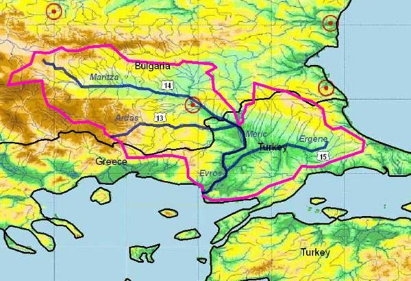
MARITZA / EVROS / MERIC Sub-basin with ARDA and ERGENE RIVERS
(sub-basin shared by Bulgaria, Greece and Turkey) |
The Maritza/Evros/Meriç sub-basin, including Arda, Tundja and Ergene tributaries, is one of the major river systems located in the eastern Balkans, with a total length of 550 km and a total catchment area of 39,000 km². About 66% belongs to Bulgaria, 28% to Turkey and 6% to Greece. About 218 km of the river are located in Greece, with 203 km of the river forming the borderline with Turkey.
Maritsa/Evros/Meriç river itself has 321 km and a catchment of 21,083 km² in Bulgaria and 3,340 km² in Greece. Major cities are Pazardik (130,000 inhabitants), Plovdiv (340,000 inhabitants), Stara Zagora (150,000) and Haskovo (80,000) as well as Edirne on Turkish river side (115,000 inhabitants). Both these municipalities and the many industries located in the basin cause a lot of pollution.
The delta area (about 150 km²) is a very important ecological site, protected under the RAMSAR convention.
The mean discharge of the river at the mouth is about 1,610 m³/s. Water is mainly used for irrigation and water supply of cities and villages.
Two major tributaries of the Maritza have transboundary sub-catchments themselves:
• Arda river flows eastward from the Eastern Rhodope mountains (240 km and 5,200 km² in south-eastern Bulgaria; only 30 km and 345 km² in Greece) including Kardjali (60,000 inhabitants) and includes various big reservoirs.
• Tundja river (350 km length and 7,982 km² in Bulgaria; ). Main cities are Kazanlak, Sliven (136,000 inhabitants) and Yambol (110,000). Please see chapter 3.15.
The tributaries Ergene (from Easter Thrace/Turkey) and Arda (Bulgaria and Greece) may induce severe floods and cause a lot of damage to downstream areas.
|
1.1. Geographical Properties |
Longitude/latitude at downstream river outlet |
Greece |
Bulgaria |
Turkey |
41o-43o N 24o-26o E
|
Source: 42o 09’ 40’’ N; 23o 36’ 00’’ E
|
40o-42o N 26o-29o E
|
Size of basin in km² |
3,340 km² (+ Arda: 345 km²)
|
21,083 km² (+ Arda 5,200 km²)
|
14,650 km²
|
Length and width in km |
180 km
|
321.5 km
|
Ergene 180 km |
Topography, including altitude range in m |
| The delimitations of river Evros boundaries are to the north the mountain chain of east Rodopi, to the south the Agean sea, to the west the palisades and low land areas which extend up to the northern Rodopi mountain chain and to the east the border line between Greece and Turkey.
Altitude from 0 to 622 m
Average altitude 150-200 m
|
Maritsa River springs from the Rila Mountain near the summit of Mancho (2,378 m a.s.l.). It runs south-east following the Balkan mountains, crossing to Thrace. Maritza river has 100 tributaries, situated symmetrically on both sides. Tundja and Arda rivers are the main tributaries. The mean catchment altitude is 579 m asl. The mean slope is 7.3 ‰ and the density of the river net 0.74 km/km². |
The topography of the region is mainly composed of Strandja Mountains lying parallel to the Black Sea with the highest peak (1,018 m) close to the Bulgarian border. In the south (the coast of the Marmara Sea), there are single peaks such as Tekir Mountain and Isiklar Mountain. Between these mountainous areas is the Ergene river basin with its tributaries flowing from north to the south and from the south to the north. |
Geology |
The geological structure of the area is composed by two basic units:
• The Thrace mass.
• A geosyncline.
The Thrace mass contains the mountain chains of Rodopi and Aimou. The geosyncline is located at the southern part of the area and mainly in the river valley till the outlet of the river.
The Thrace mass is consisted of crystalschist formations such as gneiss, granite, and volcanic rocks.
Sand, limestone and clay form the geosyncline of the river valley.
Generally the area shows a great paleontological and geological interest .
|
• Malko Belovo karst drainage catchment.
• The Perushtitsa-Ognianovo karst drainage catchment.
• The Kuklen-Dobrostan karst drainage catchment.
• The Luki-Hvoina karst drainage catchment.
• The Velingrad karst drainage catchment
• The Late Triassic karst-shaped limestones(Sakar mountain)
|
The Thrace basin in north-western Turkey is a triangle-shaped Tertiary sedimentary basin formed by extension in late Middle Eocene to latest Oligocene times. Basement-related normal block-faulting then caused rapid subsidence, and the deposi-tion of thousands of metres of thick marine clastics. Some basement faults evolved into boundary faults separating shelf areas from deep basinal realms, and greatly affected the rate of sedimentation and facies distribution in the basin. The most important boun-dary fault, at the northern margin of the basin, strikes north-west-south-east. It shows rapid variations in throw on seismic data. Large quantities of volcanic material poured onto the basin from the fault zone in the late Eocene. Fault activity was intense along the basin margins in latest Eocene times, causing continued sub-sidence in the deep basinal areas, whereas minor uplift and erosion took place along the shelf and basin margins. Many basement faults, including the north boundary fault were reactivated and underwent strike-slip motion in late Miocene times. Miocene tectonism caused intense deformation and erosion at the southern margin of the basin, obliterating the earlier sedimentary record and tectonic regime. Sedimentation in the basin was turbiditic during middle and late Eocene times. Contemporaneous reefal to shallow-marine carbona-tes were deposited on shelves and over intrabasinal palaeohighs. Alteration of marine and non-marine clastic deposition continued until the end of the Oligocene. Eocene and Oligocene sands are widespread in the basin and form good reservoirs. Although limited in areal extent, Eocene reefal carbonates form the other reservoir facies. Intraformational shales in the Eocene-Oligocene series form the source and seal facies. Organic matter in the shales is mostly of gasprone type. |
Rainfall, average annual and seasonal distribution, etc. |
Average annual rainfall:
500 - 1,100 mm
|
Between 550 and 620 mm in the low land section of the river and increasing to 900 – 1,100 mm in the mountain regions. Precipitation maximum is observed usually in May and June, while the precipita-tion minimum is observed in July and August and in some years – in February. |
600 mm with 35% in winter, 25% in spring, 27% in autumn, and 13% in summer. |
River(s), with lengths and average annual flows and seasonal distribution – flood and drought incidence and impact |
The tributaries of Evros are Ardas, Erithropotamos and Erginis.
Evros River Discharge
(1951-1956) |
| Qmean: 383 m³/s at Pythio |
| Qmin: 234 m³/s |
| Qmax:921m³/s |
Erithropotamos Discharge (1971-1973) |
| Qmean:1.62 m³/s at Kipi bridge |
| Qmin: 0.2 m³/s |
| Qmax: 5.35 m³/s |
|
River |
Annual Runoff Qav (m³/s) |
Cherna |
4,344 |
Biala |
0,948 |
Malka Arda |
1,804 |
Varbitca |
8,239 |
Varbitca |
18,509 |
Krumovitca |
7,757 |
|
River |
Annual Runoff Qav (m³/s) |
Meriç |
25.24 |
Ergene |
25.24 |
Hayrabolu Creek |
4,21 |
Tunca |
19.24 |
Seytan deresi |
2.47 |
|
1.2. Demographic Properties
|
General location of the basin
|
Greece |
Bulgaria |
Turkey |
Evros transboundary river, (Turkish Meriç river), is located on the Balkan Peninsula. About 480 km long, it rises in the Rila Mts., W Bulgaria, and flows SE between the Balkans and Rhodope Mts., past Plovdiv, to Edirne, Turkey, where it turns south to enter the Aegean Sea near Enez. |
From its springs downwards Maritsa River runs over steep slopes (over 300 %) in a glacier valley with broad bed and steep slopes. Below 1,400 m altitude Maritsa’s valley changes to a gorge, substantially narrowing itself at certain sections. Landslips can be observed near the end of the gorge. Downstream Raduil village Maritsa River runs through a broad trapezoidal valley. |
Meriç transboundary river, (Greek Evros river), is on the Balkan Peninsula. About 480 km long, it rises in the Rila Mts., W Bulgaria, and flows SE between the Balkans and Rhodope Mts., past Plovdiv, to Edirne, Turkey, where it turns south to enter the Aegean Sea near Enez. |
Total population in basin
|
133,048 people (census 1991) |
1,758,000 people |
987,216 people |
Population of principal cities or towns
|
According to census 1991:
Alexandroupoli: 35,699 inh.
Ferres: 240 inh.
Anthia: 23 inh.
Loutros: 58 inh.
|
Stara Zagora (156,000 p.e.)
Haskovo (87,610 p.e.)
Pazardjik (86,100 p.e.)
Dimitrovgrad (49,745 p.e.)
|
City-Town |
Population (1997) |
City |
Villages |
| Edirne |
134,400 |
19,397 |
| Lalapaşa |
10,767 |
8,588 |
| Meriç |
20,364 |
16,926 |
| Süleoğlu |
11,352 |
5,777 |
| Uzunköprü |
76,124 |
75,406 |
| Lüleburgaz |
111,390 |
38,356 |
| Babaeski |
52,771 |
28,037 |
| Çorlu |
154,655 |
29,084 |
| Hyarabolu |
40,583 |
23,012 |
| Malkara |
60,972 |
36,075 |
| Muratlı |
24,354 |
8,826 |
| Total |
697,732 |
289,484 |
|
Average per capita income |
11,000 € |
? |
5,000 US $ |
Industrial and agricultural GDP (Gross Domestic Product) |
No applicable data |
? |
|
Population living below the poverty line |
No applicable data |
? |
|
Other relevant characteristics |
| The Evros delta (188 km2) is protected by the RAMSAR convention and has been characterised as ‘Important Bird Area for Greece and Special Protection Area’ (Directive 79/409/EEC, Barcelona Convention). |
Approximately 66 % of the total population in the basin are connected to a sewerage system and 24 % to a WWTP. The towns that are already served by a WWTP are: Plovdiv, Nova Zagora, Pamporovo, Ihtiman and Hisarya. |
The area is one of the most developed part of Turkey, therefore the income in that place is almost 2 times higher than in the other part of TR. Industrial facilities in the area have enormously increased after the 90’ies due to the geographic properties of the area (close to Europe and the main roads to Europe) as well as the vicinity with Istanbul, the economic capital of Turkey. |
1.3 Land Uses |
• Land uses include grazing, agriculture, commercial fisheries and hunting
• The land close to the delta is used for agriculture (about 150 km²), where cotton, medic, sugar beet, sunflower, tomatoes and asparagus are grown.
|
Cereals, industrial crops, tobacco, fresh vegetables, rosaries, grassland, fallow land, forests, pastures etc |
About half of the area is used for farming (mainly wheat, sunflower, and rice). Additionally, sugar cane, sesame, corn, onion, garlic, bean, watermelon, melon, and zucchini are produced. Dry farming system without following is practiced with wheat-sunflower rotation. Not only dry farming but also irrigational farming is popular in the region. Recently industrial facilities took major roles, especially along the TEM (Turkey –Europe Motorway) and E5. |
2. WATER RESOURCES / USES AND ENVIRONMENTAL SITUATION
|
Greece |
Bulgaria |
Turkey |
2.1. Total available surface and groundwater resources |
Mean annual surface water resources: 6,800 hm³ |
4,030 x 106 m³ |
Surface water demand 302 x 106 m³/year
Groundwater (planned irrigation)
116.8 x 302 x 106 m³/year
|
Net usable capacity of surface reservoirs
|
|
Reservoir |
Useful storage
(in M m³) |
Batak* |
290.0 |
Golyam Beglik |
58.1 |
Shiroka Polyana |
20.7 |
Pyasachnik |
206.5 |
Vacha |
201.6 |
Krichim |
20.3 |
Belmeken |
140.2 |
Chaira |
4.4 |
Topolnitsa |
133.5 |
Trakiets* |
90.0 |
Ovcharitsa |
31.0 |
Domlian |
25.0 |
Garvanovo |
25.0 |
Rozov Kladenets |
13.3
|
|
Name of
Irrigation
(Dam)
|
Net
Irriga-tion
(ha)
|
Water
Demand
(106 m³)
|
Süloglu Dam |
13,500 |
88.40 |
Süloglu Dam |
3,500 |
75.50 |
Karaidemir |
7,720 |
75.50 |
Karasaz |
4,350 |
43.11 |
Kirishane |
1,300 |
6.73 |
Küplü |
1,300 |
8.06 |
Altinyazi-Alic |
2,200 |
29.30 |
Kadiköy Dam |
3,750 |
37.25 |
Total |
37,620 |
302.2 |
|
|
Total surface water abstractions (estimated where nt measured) |
? |
About 250 abstractions |
? |
Total groundwater abstractions (estimated where not measured) |
? |
104,000 x 106 m³ |
? |
Surface and groundwater quality (in general categories only) |
• Measurements of heavy metals and organic chloride hydrocarbons in the sediments of Evros river indicate that the concentration of these pollutants reaches sometimes high values.
• The measurements of organic chloride hydrocarbons at the sediments indicated also high maximum concentrations.
|
Water quality:
First category in the high mountains and Second category in the lowlands
|
Water quality is observed regular-ly by EIE (Electrical Power Resources, Survey and Development Administration of Turkey) on Ergene, Tunca (Tunja) and Meriç (Maritza).
Measured prameters:
Water temperature, suspended sediment, pH, anions, cations, Na, organic load, total salt, Bohr
|
Water uses (total, by sector, principal uses, current (estimated) and future (projected), include in-stream uses (fisheries, etc.) where appropriate) |
Water supply, irrigation, industrial use, hydroelectric power, thermal waters |
For water supply: 118,000 x 106 m³ |
Agricultural purposes (irrigation), industrial water supply (Lüleburgaz-Çorlu-Çerkezköy), water supply for municipalities.
|
Deficits and other resource concerns (e.g. quality, extremes, environmental degradation) |
There are two problems of the Evros river and its wetland:
First, the sea intrudes into the river up to 30 km upstream from its mouth during the summer. The second problem is the pollution of the river, which has various origins. There are a) pollutants from various point sources (industries) close to the river in the three countries Bulgaria, Turkey and Greece. and b) pollutants from surface agricultural pollution.
|
The majority of towns in the Maritza basin have no domestic treatment facilities which may produce water quality problems |
Ecological and agricultural salt water intrusion from the sea into the Meriç delta, industrial pollution in the zone of Lüleburgaz-Çorlu-Çerkezköy. |
|
Sensitive ecosystems, biodiversity and environmental impacts in the basin
|
Drainage works carried out between 1950 and 1970 (including channel construction and embankment of the river) caused major hydrological and land use changes in the delta. As a result, parts of wetland habitats have been lost and others seriously modified. |
|
The area has very sensitive eco-systems especially the Meriç (Evros) delta for immigration of the birds seasonally. Also wetlands such as Gala Lake are very sensitive, regarding salt water intrusion from Aegean sea if the stream level is not high enough in the Meriç (Evros) (Matise) River. |
3. BASELINE INFORMATION AVAILABILITY
|
Observation networks |
Greece |
Bulgaria |
Turkey |
Permanent water quality moni-toring is in place along Evros River. |
Reservoir |
Monitoring
Station (s)
|
Batak* |
523, 524 |
Golyam Beglik |
|
Shiroka Polyana |
|
Pyasachnik |
|
Vacha |
|
Krichim |
|
Belmeken |
|
Chaira |
|
Topolnitsa |
101 |
Trakiets* |
533 |
Ovcharitsa |
|
Domlian |
|
Garvanovo |
|
Rozov Kladenets |
105 |
|
Permanent water quality, flow monitoring is in place along Meriç, Ergene and Tunca rivers by EIE.
Station No: River
103 Meriç
104 Yunca
105 Ergene
|
Maps, with available scales, GIS and remote sensing imagery
|
available |
available |
available |
|
Data archives and their adequacy |
• Ministry for Environment, Physical Planning and Public Works.
• Public Power Corporation (DEI)
• Ministry of Agriculture
|
• Ministry of Environment and Water (MoEW)
• Executive Environment Agency
• Ministry for Regional Develop-ment & Public Works (MRDPW)
• Municipalities + water companies
|
• DSI (State Hydraulic Works)
• EIE (Electrical Power Resour-ces, Survey and Development Administration of Turkey)
• ITU (Istanbul Technical Univer-sity)
|
Research centers |
EKBY (Greek Biotope/Wetland Centre)
AUTH (Aristotle University of Thessaloniki)
|
NIMH |
DSI Regional office located in Edirne, Universities (ITU), Turkish Scientific and Rsearch Concuil |
NAME AND CONTACT DETAILS OF PERSON(S) COMPLETING THIS FORM |
Prof. Jacques GANOULIS
Hydraulics Laboratory
Civil Engineering Department
Aristotle University of Thessaloniki
54124 Thessaloniki, Greece
Tel: +30-231-099.56.82
Fax: +30-231-099.56.81
e-mail: iganouli@civil.auth.gr
|
Roumen ARSOV, Prof., D.Sc., Eng.
Dean, Faculty of Hydrotechnics
University of Architecture, Civil Engineering & Geodesy
1 Chr. Smirnenski Blvd., 1046 Sofia, Bulgaria
Tel./fax: +359 2 8656 648; 8668995
E-mail: r_arsov_fhe@uacg.bg
Assoc.Prof. D-r.Snejana DAKOVA
NIMH-BASc, 66 «Tzarigradsko shausse» bul; 1784 Sofia, Bulgaria
E-mail Snejana.Dakova@meteo.bg
Tel (+359 2) 975 39 86
Fax (+359 2) 988 03 80 / 988 44 94
|
Dr. Sevket COKGOR
Istanbul Technical University, School of Civil Engineering, Department of Hydraulics,
34469, Maslak, Istanbul, Turkey.
Tel: +90 212 285 6848
Fax: +90 212 285 3710
cokgor@itu.edu.tr
|
Bulgaria |
Greece |
Turkey |
| Maritza and its right tributary Arda river has the largest part of its basin in BG. Small parts (mainly the lower section and mouths) are in Greece and Turkey (including Ergene river). |
Maritza River |
Arda River |
Evros and Arda Rivers |
Meric and Ergene Rivers |
|
4.1. International agreements / conventions and national legislation |
Although Maritza/Evros/Meric River, shared by Greece, Bulgaria and Turkey, is the second longest river after the Danube in the Balkans, this river and its tributary Arda (shared by Greece and Bulgaria) are lacking considerable recent bilateral or trilateral agreements. This situation is mainly due to the past non-trusted political relationships between the three countries.
Parts of the Evros/Meric River bed serve as state border between Greece and Turkey. Thus, both Evros and Ardas rivers are located in a military controlled area. Special permit from military authorities is needed for all scientific or other activities near the rivers.
Its delta is an important bird area protected by the Ramsar Convention and the Bern Convention on special species of flora and fauna. It is also cited in the list of regions of special protection according to the EU Directive 79/409/EEC and the national Greek legislation 66/81.
|
The bilateral cooperation in the use of water dates back to 1964.
Both countries ratified the Helsinki Convention for protection and use of transboundary watercourses (1992; in GR in force since 1996) and the Espoo Convention.
After the implementation of Helsinki Convention, GR and BG are cooperating by a joint monitoring in the three common river basins, i.e Struma, Mesta (including the tributary Dospat) and Maritsa (including the tributary Arda).
In the following years, bilateral agreements on the use of other transboundary rivers waters were signed. Also, cooperation in scientific and technical field for the best management of water resources is well established.
The main agreements on the protection and use of transboundary watercourses are:
• GR-BG agreement on co-operation for the use of watercourses flowing through the two countries (Legislative Decree 4393/1964);
• Second Protocol of the GR & BG agreement about the regulation of economic questions and development of the economic co-operation (Legislative Decree 4393/1964);
• Agreement between GR & BG concerning the formation of a joint committee for the cooperation in the field of electric energy and the use of cross-border river waters (Sofia, 1971);
• Agreement between GR & BG on scientific and technical cooperation (Athens, 1973/1976);
• Protocol for the Joint GR-BG Technical Working Group and Environment Group (approved 1990);
• Protocol for the co-operation of GR-BG Experts for flood control of Strymonas River (approved on 1980);
The Agreement from 1964 on flood protection refers to the section downstream of a series of reservoirs in Bulgaria. It operates between local authorities (when the BG reservoir gates release excess water upstream, they send a warning to the GR local authorities).
• Protocol of the Meeting of the Joint GR-BG Committee of Experts for the preparation of a common proposal to the EU for the joint monitoring and control of water quality and quantity of the transboundary rivers Maritsa/Evros, Mesta/Nestos and Struma/Strymonas. (1991).
Expert comments on the new laws: Bulgarian National legislation issued since 1999 is strictly harmonized with the EU one in the field of Water Resources Management. |
Ergene river has its drainage basin in Turkey (10,195 km²; discharge 0-1,500 m³/s, average 27.5 m³/s), covering most of the Thrace province with 24,760 km². There are 1 million people, lots of industries (textile, pharmacy, dairy, tanneries) and intensive agriculture (wheat, sunflower, rice). It enters into Meric upstream the transboundary delta.
Recently, the TR Ministry of Environment and Forestry approved the environment management plan for the Ergene Basin. |
| For this information please see the BG section in chapter 3.11 |
Its delta is also cited in the list of regions of special protection according to the national Greek legislation 66/81.
A new law in Greece (L3199/03) activating the EU Water Framework Directive (WFD) 2000/60 provides all necessary actions for river management but it will take some years to establish an international river com-mission and develop joint integrated water resource management plans.
|
|
Bulgaria
|
Greece |
Turkey |
|
4.2. Institutions / distribution of responsibilities |
| For this information please see the BG section in chapter 3.11 |
At local level, The Region of Eastern Macedonia and Thrace, located in Komotini, acts according to the new water law as regional coordinating authority of the basin.
The Prefecture of Alexandroupolis manages and plans the Evros irrigation system.
Recently, a new management body (Foreas Diachirisis) has been formed following the Directive 92/43/EEC, now responsible for water quality management of the Evros delta.
The Institute of Geology and Mining Resources (IGME) is the national agency in charge of monitoring, evaluation and management of ground-water resources. A regional section is located in Xanthi and is responsible for groundwater resources in Evros region.
TOEV (Water Irrigation Company) is in charge of the management of irrigation water rights and metering for farmers in Evros irrigation region.
DEYA, Municipal Enterprises for Water Supply and Sewage of Komotini and Alexandrou-poli are respon-sible for fresh water abstraction and distribution to local towns.
Municipalities are in charge of urban water supply and sewage in cities with less than 30,000 people.
The Democritus University of Thrace (DUTh) conducts research and consulting activities related to the water management of the Evros region.
The Aristotle University of Thessaloniki (AUTh) is involved in the Evros River hydrology and water quality assessment as well as in numerous cross-border cooperative programmes with Turkish and Bulgarian institutions. These activities are supported by Greek national and regional funds.
The UNESCO Chair/INWEB (International Network of Water Environment Centres for the Balkans) has included the Evros River catchment, amongst other transboundary catch-ment areas in the Balkans, in an effort to implement the concept of Integrated Water Management and to increase capacity building among all local partners. Two international programmes funded by UNESCO/ROSTE and ISARM-UNESCO/IHP are presently under development in order to identify key issues and priorities for action in the area. Also specific programmes for Water Education and Training are planned for the years to come.
At national level, the Ministry of Environment is responsible for integrated water management. For transboundary rivers the Ministry of Foreign Affairs is also involved. Next are the Ministries of Economics, of Agriculture and of Defence to some extend. |
State Hydraulic Works (DSI) is responsible for all surface and sub-surface water resources in Turkey (monitoring and planning, designing, constructional, and operational activities) based on the following law:
Law Number 6200: DSI's Establishment Law
Enacted: December 18, 1953; Published in Official Gazette: December 25, 1953; Effective: February 28, 1954
|
4.3. Planning / Decision-making processes |
For this information please see the BG section in chapter 3.11
|
No integrated planning of water resources is operational in the Evros river catchment. The decision-making process is not effectively coordinated between local, regional and national levels. Most of the water is used in a non-sustainable way for irrigation. There are no plans for mitigating catastrophic floods (like in 1997 and 1998).
Concerning planning of water quality, parts of the Evros and Ardas catchments on Greek side are designated as NATURA 2000 sites. For these, planning and decision-making is carried out according to the provisions of the relevant national and EU legislation.
|
Decisions are shared between the Ministry of Energy and Natural Resources and Ministry of Environmental and Forestry, and local communities.
State Hydraulic Works (DSI) does the planning and has several irrigation projects.
The Ministry of Environment and Forestry has carried out several wastewater treatment projects in the basin.
|
4.4. Finances |
| For this information please see the BG section in chapter 3.11 |
All projects related to water resources such as irrigation, flood protection, water supply etc. are supported by TR national funds. |
All projects related to water resources such as irrigation, flood protection, water supply etc. are supported by TR national funds. |
Bulgaria
|
Greece |
Turkey |
4.5. Past and present major projects (including listing of donors’ interest) |
Maritza River |
Arda River
|
Evros and Arda Rivers |
Meric and Ergene Rivers |
| Turkey and Greece decided in 1994 to built a dam on Meric (even though the area is not suitable for water storage during dry periods) for protecting the delta area from salt intrusion. The project never started. |
The following projects and research have been developed, concerning the Maritza/Evros river basin:
• Water Quality Protection and Management in Maritza River Basin, Project Bul /94/ 003, UNDP, MoEW, Sofia 1997.
• Protection and Management of the Water Quality in the Maritsa River Basin, UNDP, MoEW, Final Report, Sofia 1998.
• The Study on Integrated Management for the Maritza River Basin in Bulgaria - Japan Intl. Cooperation Agency (JICA), 1997-1998, MoEW.
• Ichthyofauna of the East Rhodopes (South Bulgaria): Composition and Distribution Pehlivanov, L. 2000, Acta zool. Bulg, 52 (3): 45-53.
• Uzunov, Y. & S. Kovachev. 1985 – Hydrobiology, 24:33-47
• Water Quality Protection and Manage-ment in Maritza River Basin, Diagnostic Study of the nature, magnitude and sources of water pollution in the basin of Maritsa River and its tributaries, UN, Department of Economic and Social Affairs, Sofia, September 1998.
• Evaluation Of The Assimilative Capacity And Admissible Pollutant Load In Maritsa River And Its Tributaries, UNDP Ministry Of Environment And Water UN Department For Development Support And Management Services Vodokanal-engineering, July 1998.
• Review of water pollution in the transboundary river basins: Maritsa Tundja, Arda, Mesta and Struma. Phare 1999 (July). Draft Final Report.
• Review of water pollution in the transboundary river basins: Maritsa Tundja, Arda, Mesta and Struma. Phare 1999 (July). Draft Final Report.
• Research Studies, Expertise and Consultations for Different Engineering Structures on the South Bulgarian Rivers: Struma, Mesta, Arda, Maritsa and Tundja, 1998 – 2002, St.Modev.
• Feasibility Study for Identification of Sen-sitive Areas in Mesta, Struma, Arda, Tundja and Maritza River Basins in Accordance with the Criteria of Directive 91/271/EEC, 2003, LDK Consultants, Engineers and Planners, Athens, MoEW – Project BG No 9904-04.02
• Review of Water Pollution in the Cross Border Region of South BG, PHARE Programme, Carl Bro Group, July 1998.
In addition, four wastewater treatment plants (WWTP) have been built in the Maritza river basin at the towns of Ihtiman, Plovdiv, Koprivshtitza and Nova Zagora. |
The following projects and research have been developed, concerning the Arda river basin:
• Review of the water pollution in the transboundary river basins: Maritsa Tundja, Arda, Mesta and Struma. Phare 1999 (July). Draft Final Report.
• Research Studies, Expertise and Consultations for Different Enginee-ring Structures on the South BG Rivers: Struma, Mesta, Arda, Maritsa and Tundja, 1998–2002, St.Modev.
• Feasibility Study for Identification of Sensitive Areas in Mesta, Struma, Arda, Tundja and Maritza River Basins in Accor-dance with the Criteria of Directive 91/271/EEC, 2003, LDK Consultants, Engineers and Planners, Athens, MoEW – Project BG No 9904-04.02
• Review of Water Pollution in the Crossborder Region of South BG, PHARE Program, Carl Bro Group, July 1998.
• A Study of Maximum Runoff Con-ditions and Design Floods Transmission from Reservoirs of the ''Gorna Arda'' Cascade, 1998, St.Modev.
• Contemporary Saprobiological Characteristics of Arda River in the Section of Future Janeva, I., Vidino-va, Y., Tyufekchieva, V. 2001 ''Gorna Arda'' Cascade Building. – Acta Zoologica Bulgari-ca, 53 (2): 37-46.
• Ichthyofauna of the East Rhodopes (South Bulgaria): Composition and Distribution Pehlivanov, L. 2000, Acta zool. Bulg, 52 (3): 45-53.
• Water Quality Protection and Management in Maritza River Basin, Diag-nostic Study of the nature, magnitude and sources of water pollution in the basin of Maritsa River and its tributaries, UN, Department of Economic and Social Affairs, Sofia, September 1998.
• Evaluation Of The Assimilative Capa-city And Admissible Pollutant Load In Maritsa River And Its Tributataries, UNDPMinistry Of Environment And Water UN Depart-ment For Develop-ment Support And Management Services Vodokanal-engineering, July 1998.
|
A major plan for flood protection of the Evros area was developed in the 50’s, after World War II. There is a need to update and modernise the flood control and mitigation planning in the area. A preliminary study was commissioned in 1999 (one year after the devastating floods in 1998) to Aristotle University of Thessaloniki (AUTh) by the Region of Eastern Macedonia and Thrace. Recommen-dations for further studies and measures were not followed up.
Most of major past projects in the Evros catchment refer to the delta. The first proposals for the protection of the delta region were made by the Hellenic Society for the Protection of Nature in 1962. Since then, numerous projects funded by national and EU sources (e.g. LIFE, LEADER etc) concern species and habitat conser-vation, ecotourism development, etc. Projects were realized by nationnal (e.g. Hellenic Ornithological Society etc) and international agents (e.g. WWF Intl.)
|
Several irrigation dams were constructed since 1970 (such as Kayalıköy, Süloğlu, Karaidemir dams). There is also various groundwater irrigation and the Edirne city flood protection project. |
4.6. Stakeholder Participation |
| For this information please see the BG section in chapter 3.11 |
Though many of the management and conservation projects in the area are quite well defined, stakeholder participation was never a priority. All major decision-making processes take place at central national level, without any involvement or participation of local stakeholders. Only recently, under the application of the WFD, reference is made to stakeholder information and participation. |
Main stakeholders in the Meric and Ergene sub-basins are farmers, some communities and industries. |
4.7. Awareness / Communication |
| All the projects and activities related to water and environment in the Maritza and Arda river basins face public awareness.
Communications between the responsible institutions, stakeholders and society are good and in accordance to the national legislation.
|
There are no systematic plans or efforts for public sensibilisation and awareness on the use of water from the river.
In the Evros delta area, there is a visitor centre and a small natural history museum.
A youth event on Ardas river banks might be considered as a wide awareness/communication action (organized by local authorities over the last 10 years).
|
Generally speaking, the level of public awareness in the entire country is high. Local people oppose pollution of surface water from industrial activities. |
Bulgaria
|
Greece |
Turkey |
5. CONCLUSIONS / RECOMMENDATIONS |
5.1. Identification of critical problems (transboundary situation)
- problems related to the resource
- problems associated to uses, needs and demands
- problems affecting ecosystems
|
Problems, related to water resources:
• Global climate change affected the region over the last 20 years, resulting in a ca. 30 % decrease of precipitation and associated water resources.
• Transboundary river water resource distribution between BG and GR are for years subject of negotiations. It seems now that a reasonable agreement has been achieved.
Problems, associated with the uses, needs and demands:
• A shortage of water for drinking and irrigation exists in some settlements and regions.
• Construction of dams is necessary in order to regulate the runoff and to assure the necessary water quantity during the year.
Problems affecting ecosystems: Construction of WWTPs is necessary for most of the towns downstream the main river course and for some industrial enterprises in the basin.
|
- No recent international agreements.
- Absence of an International River Committee.
- Poor cooperation between Greece and Turkey on environmental issues.
- 2-3 dams on Bulgarian territory may cause sudden floods on Greek side.
- Dumping of dangerous pollutants (e.g. radio-nuclides) on BG side.
- Sand extraction from Ardas for quartz production
- Both rivers supply irrigation water to all three countries.
- Irrigation systems are ineffective and need modernisation.
- There is no agreement on the schedule of water abstraction.
- Illegal hunting and overgrazing
- Illegal water abstractions.
|
Water discharge of the Meric depends on the operating rules of the Bulgarian dams, where water storage occurs in the summer period. An agreement is needed between the 3 countries for all discharges and ecological issues.
Major problems are untreated industrial wastewater discharges and pollution from overuse of fertilizers and pesticide. Uncontrolled water supply for irrigation and industrial purposes is also an important problem. The cities of Çorlu and Lüleburgaz in the Ergene basin have limited flood risk.
The Meric delta is important for rice production (use of river and also groundwater). When the water level is too low because of the limited releases from the BG dams, salt water intrusion occurs (affectting water quality and the wetland life). |
5.2. Main achievements |
• Centralized water supply system for more than 98 % of the population
• Regular and long term monitoring of river water quantity and quality as a part of the national monitoring network. Part of it belongs to the EUROWTERNET.
• Establishing special monitoring stations at the both sides of the state border between BG and GR.
• Inventory of water pollution sources and loads
• Establishment and maintenance of river water quality categories along the river reaches.
• Establishing a River Basin Directorate and an associated River Basin Council, according to the national and EU legislation.
• Existence of a Regional Inspectorate of Environment and Water
• Established “sensitive” and “less sensitive” zones in the river basin
|
- It is only during the past few years that GR and BG have started some timid efforts for an agreement at any scale (local or national) on the protection and management of Evros and Ardas. However none of these efforts has come to a successful result.
- Unfortunately there are no similar efforts with Turkey, although the political climate between the two countries has recently very much improved.
- Arda River is well-known for its annual music youth event.
- Some eco-tourism activities are organized in the area but not in a systematic way. |
Irrigation capacities have increased to 40,000 ha. Water quality is seriously monitored due to public pressure. |
| |
Development of the “Gorna Arda” project for construction of a 3 dams cascade for electric energy production. |
|
|
5.3. Key challenges |
Maritza River |
Arda River
|
Evros and Arda Rivers |
Meric and Ergene Rivers |
• Construction of WWTPs at the settlements over 100,000 PE (by 2011) and over 2000 PE (by 2015)
• Development of a River basin Management Plan (by 2009) according to the Water Act and EU WFD. |
- International and local agreements
- Integrated joint water management planning
- Flood protection
- Sustainable agriculture
- Wetland function analysis
- Wetland socio-economic evaluation
- Stakeholder engagement and parti-cipation
|
Realisation of a national plan within a yet inappropriate political and economical frame. |
| |
Construction of the “Gorna Arda” 3 dams cascade for electric energy production. |
5.4. Donor interests |
| The necessary major investments in the water sector in the region is expected to come from international sources and mainly from EU pre-accession funds (ISPA programme – by 2007), cohesion and structural funds (after 2007), etc. |
Until recently no private donations were attracted to support management actions for these two rivers. An effort should be made to indicate to potential donors the priority actions to be financed and the associated benefits for economic growth, environmental protection and political stability in the region. |
There is no recognized special donor interest. |
| |
Bilateral agreement exists between Bulgaria and Turkey for financing the “Gorna Arda” project implementation. |
Bulgaria
|
Greece |
Turkey |
5.5. Recommended priority actions |
| • Construction of WWTP at the towns Pazardjik, Dimitrovgrad, Stara Zagora, Haskovo, Hisarya, Chirpan, Srednogorie and Rakovski. |
• Construction of WWTP at the towns of Smolyan, Madan, Roudozem, Zlatograd and Kurdjali |
- Control wastewater and pollutant effluents in Bulgaria
- Monitor water quality
- Preserve river banks
- Prevent river water salinisation in the delta
- Early warning system for floods and pollution events.
|
Further increase the public awareness for ecological issues; updating the water supply planning for irrigation, industries, effective treatment of industrial and municipal wastewater. |
| • Development of a River Basin Management Plan |
6. MAIN REFERENCES, BACKGROUND DOCUMENTS |
Water Act (1969 amended 1999 - 2004)
Regulations, associated with the Water Act (1999) – 12 in number
National Strategy for Development and Management of Water Resources (2004)
Implementation Program for Directive 91/271/EC Concerning Urban Wastewater Treatment (2003), MEW, Sofia
National Program for Construction of Sewer Networks and Main Trunks to the WWTPs for Settlements with Over 10 000 PE (2001), MRDPW, Sofia
National Program for Priority Construction of Urban Waste water Treatment Plants for Settlements with Over 10 000 PE (1999), MEW, Sofia
Ordinance for Establishing of Sensitive Zones (2003), MEW, Sofia
|
- Data, papers, books and publications from AUTh (Thessaloniki), DUTh (Xanthi) and the Ministry of Environment, Athens
-- OECD 2000, Environmental Performance Reviews: Greece - NATURA 2000 national database
- Greek Biotope/Wetland Centre records
|
Data from State Hydraulic Works and the Ministry of Environment and Forestry of Turkey; Internet, private sources. |
|