| 1. |
GENERAL INFORMATION |
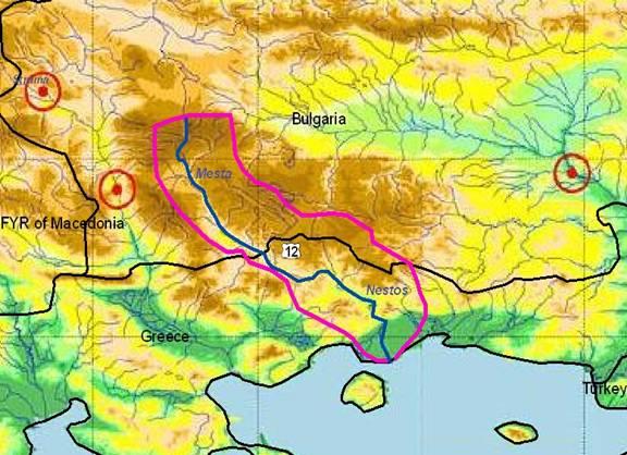
MESTA / NESTOS RIVER Sub-basin
(sub-basin shared by by Bulgaria and Greece) |
Mesta (Nestos) River rises in the Rila mountains in southern Bulgaria and flows some 230 km through Bulgarian and Greek territory before emptying into the North Aegean Sea. About 126 km of the river flow through Bulgaria (2,770 km² catchment) and about 130 km through Greece.
The total catchment area of the river is 5,613 km² (2,843 km² located in Greece). The flow of the Nestos river is used by both countries for municipal water supply, irrigation and hydroelectric power production. The past estimated mean runoff of the Nestos River is 20 to 30 m³/s and the annual discharge 1,120 mio. m³.
Mesta River is the most important water resource in its region and has been subject of bilateral negotiations for many years. The famous delta (440 km²) is protected as a RAMSAR site but is in danger due to pollution caused by various human activities and to large-scale hydraulic works (dams) constructed along the river.
The morphology of the catchment is mountainous with the exception of the delta region. The climate is Mediterranean and becomes transitional Mediterranean further north. According to recorded mean monthly flows (1965-1990), the maximum discharge was rarely above 150 m³/s, while the minimum was often less than 10 m³/s. During recent years 3 dams have been constructed in the Greek river section (Thisavros, Platanovrisi and Temenos) for hydropower generation and irrigation.
The Greek part of the Nestos River Basin belongs to three prefectures (Drama, Xanthi and Kavala), comprising 82 communities (in total about 35,000 inhabitants. Only Chrisoupoli as the largest town (7,100 inhabitants) has a central sewerage system and treatment plant. |
Bulgaria |
Greece |
1.1. Geographical properties |
Longitude/latitude at downstream river outlet |
Latitude at outlet: 42° 07’10’’N
Longitude at outlet: 23° 35’20’’ E
|
Latitude at outlet: 40.51 N
Longitude at outlet: 24.41 E |
Size of basin |
| 2,770 km² |
2,843 km² |
Length and width in km |
| 126 km |
130 km |
Topography, including altitude range in m |
The river springs from Rila Mountain.
Altitude range: 0 m to 2,925 m
|
Altitude range: 0 m to 2,925 m |
Geology |
| Granites paleozoic (Rhodopes), Granitoids cretaceous (Rila-Pirin), Volcanics paleogene (Rhodopes-Pirin), Gneiss and marble (Lekani-Thrace), Oligocene (Pirin), Neogene-Quaterna-ry (Graben filling), Quartenary alluvium (Mesta and Nestos delta) |
Granites paleozoic (Rhodopes), Granitoids cretaceous (Rila-Pirin), Volcanics paleogene (Rhodopes-Pirin), Gneiss and marble (Lekani-Thrace), Oligocene (Pirin), Neogene-Quaterna-ry (Graben filling), Quartenary alluvium (Mesta and Nestos delta) |
Rainfall, average annual and seasonal distribution, etc. |
792 mm/y.
The driest months are August and September, with monthly rainfall precipitation from 25 to 38 mm
|
The annual rainfall is 522mm with 86.3 days of rain annually. The southern part of the catchment is characterized by Mediterranean climate – mean annual temperature 15.4° C, mean humidity 70-72% and mean rainy days 90.3. In the whole of the catchment the mean annual rainfall is 830mm and mean annual rain volume is 2,070x106 m³. So in the mountainous area the temperature is low in winter time and not so high in summer time, while in lowlands the winter is soft and the summer dry and hot. |
River(s), with lengths and average annual flows and seasonal distribution - flood and drought incidence and impact |
|
|
Annual Runoff Qav* (m³/s)
|
B.Mesta |
56,7 |
1,628 |
Leevestitsa |
13,2 |
0,287 |
Cherna Mesta |
33,2 |
0,746 |
Biala Reka |
33,8 |
0,288 |
Demianitsa |
35,7 |
1,439 |
Iztok |
55,4 |
3,021 |
Iztok |
361 |
6,538 |
Kanina |
187 |
2,510 |
Kanina |
231 |
2,889 |
Bistritsa |
82,4 |
1,339 |
Dospatska |
236 |
3,158 |
Karadja dere |
112 |
1,919 |
|
|
|
Annual Runoff Qav* (m³/s)
|
Nestos |
2,843 |
40 |
Diavolorema |
356.4 |
|
Arkoudorema |
283.3 |
|
Xerias |
14.1 |
|
Psyhro Rema |
28.4 |
|
Mousda Rema |
203 |
|
Kamperoglou Rema |
11.9 |
|
Dasorema |
11.2 |
|
Melissorema |
11.2 |
|
Maurorema |
11.4 |
|
Agios Georgios |
10.7 |
|
Kastanitourema |
60.9 |
|
Dihalorema |
28.5 |
|
Rema |
45.7 |
|
Megalorema |
10.8 |
|
Mauromaterema |
46.8 |
|
Leukes Rema |
9.5 |
|
Mulorema |
93.1 |
|
|
1.2. Demographic properties |
General location of the basin |
| The catchment area of the Mesta river basin is located mainly in the South Bulgarian climatic sub-area of the Continental Mediterranean climatic zone. |
The Nestos/Mesta river rises in Rila mountain (2,716 m) in south Bulgaria and is discharging into the Thracian Sea east of the city of Kavala. The river basin is confined by the Rila mountains in the north, Pirin, Orvilos and Falakron in the west, Rhodope mountain in the east and the Gulf of Kavala in the south. |
Total population in basin |
| 137,000 people |
42,164 people |
Population of principal cities or towns |
Razlog (17,800 p.e.) Bansko (9,400 p.e.)
|
Chrisoupoli (8,004 p.e.) |
Average per capita income |
| 4,108 (US$/year) |
(US $/year): 9,408 |
Industrial and agricultural GDP (Gross Domestic Product) (2003) |
| NA |
(US $/year): 15,200 |
Population living below the poverty line |
| NA |
? |
Other relevant characteristics |
| The two towns have a sewerage network while none of them has a WWTP, consequently all wastewaters are discharged untreated to surface waters via the sewerage collectors, which serve 98% of the population of Razlog and 71 % of Bansko. |
? |
1.3 LAND USES |
? |
The main land uses include park land and protected fauna/flora areas, skiing, forestry, grazing, dry and irrigated agriculture, hydro-electricity, urban and scattered industry, fish farming and ponds and coastal tourism. A fairly detailed GIS land use map is available.
(60% Forest,1% Water, 15% Other vegetation, 11% Cropland, 2% Built-up area, 11% Other ) |
2. WATER RESOURCES / USES AND ENVIRONMENT SITUATION |
Total available surface and groundwater resources |
Mesta river has 25 tributaries, 13 of them are first order. The biggest is Dospatska river which flows into Mesta on GR territory. The main river and its tributaries come from the highest mountains Rila, Pirin and Western Rhodopes. Most Mesta tributaries, entering in its upper reaches, have their sources at the southern slopes of Rila mountain (2,424 m).
The lakes in the Mesta river basin have a glacial origin. They are situated on Rila and Pirin mountains.
26 lakes below to Rila mountain and are sources of the tributaries of Bijala Mesta river. These lakes are situated on the highest part of the mountain over 2000 m at the bottom of the cirque. The morphological characteristics were obtained during expedition measurements in the 1960th. 83 Mesta river basin lakes belong to Pirin mountain and are situated also over 2000 m. With their glacier origin, they gave sources to many streams which are right tributaries of Mesta river, namely: Demijanitza river (from Vassilachky lakes), Banderitza (from the same named lakes) and so on.
The first gauging station in the Mesta basin was completed in 1927 at Momina koula. The water level has been observed since 1936 (start of water quantity monitoring). So, the available hydrological information date from this time. Today, the observation is implemented in 18 g. Stations (11 are equipped with water level records). The samples for sediments are taken in 3 GS.
The river flow is strongly influenced by human activities developing in the river net and the catchment area.
|
Nestos river has 18 tributaries. Two hydro-elec-tric dams constructed in the northern part of the catchment regulate the river flow. The Thisavros and Platanovrisi dams produce in total 665 GWh. The effect of the dams is observed downstream with high flow variations. According to the PPC (DEH) the mean monthly flow for the period 1965-1990 was rarely above 150 m³/s while the minimum flow was often lower than 10 m³/s. For environmental conservation reasons it was decided that the Delta should receive at least 6 m³/s. The aquifers formed in the delta region (sand, sandstone) are fed laterally by the ground flow of the river and from the marbles that are formed on the north, resulting in the formulation of a rich aquifer catchment.
At the eastern part of the delta the rocks of gneiss form an impermeable barrier and, as a result, groundwaters move towards north-west enriching the western part and forming in this area rich aquifers.
The area "Ori Lekanis" is between the three cities of Kavala-Drama-Xanthi and covers an area of 1,300 km². The altitude ranges from 1 to 1,400 m and is crossed by the Nestos River. This area contains the most important karstic aquifer of the region. This aquifer could meet the needs of the region for water supply and industrial use. Two main hydrogeological catchments are defined with annual potentials of 80x106 m³ and a third one with 25x106 m³. In the area "Ori Lekanis" there are 25 cold springs, 1 thermometallic and 57 boreholes. The karstic aquifer system of the area in combination with the river has a complicated geological and tectonic structure. |
Net usable capacity of surface reservoirs |
| 431,4 hm³ net usable capacity |
? |
Total surface water abstractions (estimated where not measured) |
| The Mesta river flow is used mainly for the production of electricity and irrigation. The catchment area of Mesta river pertains to the semiarid regions, so here the gross irrigation rate is the biggest in BG (up to 400 m³/s, mainly surface irrigation with low irrigation efficiency). The existing power plants are in process of privatization. |
Water is used mainly for the production of hydroenergy and irrigation purposes. The two constructed dams can withhold a total volume of 834*106 m³ when operating at MOL. |
Total groundwater abstractions (estimated where not measured) |
? |
The northern part is not characterised by the existence of important aquifers. In the middle part, the marbles form important aquifers that provide 38*106 m3 of high quality water that is used for the supply of many municipalities. Water for irrigation originates from Nestos and from about 50 drills each of 150-170 m³ (according to the Land Irrigation Service).
Groundwater at the delta is used for irrigation, water supply and vivariums. At least 2,000 shallow drills exist in the area. |
Surface and groundwater quality (in general categories only) |
See table 1 below |
During the monitoring through the Interreg program it was concluded that the river is more polluted near the borders with observed heavy metal concentrations from industrial activities, while the quality improves further downstream. Towards the Delta it deteriorates again due to agricultural pollution. According to the EU standards the water quality is characterized as A3 drinking water. (See table 2 below) |
Water uses (total, by sector, principal uses, current (estimated) and future (projected), include in-stream uses (fisheries, etc.) where appropriate) |
| Water supply, irrigation and electric production |
Water is used mainly for producing hydro-energy (0,7%), irrigation purposes (92,7%), for urban use (6%) and for industrial use (0,7%). |
Deficits and other resource concerns (e.g. quality, extremes, environmental degradation) |
Annual Flow 235 M m³
The average yearly flow of the springs in the sub - basin is 1.575 l/s. The rest ones, which drain their waters into adjacent basins have an average yearly capacity of about 100 l/s. The average and the minimum long-term hydraulic conductivity of groundwater, including the water escape to adjacent sub-basins, are estimated to be 37,2 l/s.km² and 11,0 l/s.km2, respectively. |
Average annual available surface water (M m³): 4,000
Average annual available groundwater (M m³): 300
Net usable capacity of major surface reservoirs (M m³): 1,280
Average annual surface water abstractions (M m³): 200
Average annual groundwater abstractions (M m³): 60
|
ENVIRONMENTAL PROPERTIES |
Sensitive ecosystems, biodiversity and environmental impacts in the basin |
There is a river diversion to Evros since 1989, where 164 million m³ are currently diverted (during the summer and the dry autumn months waters are not transferred). More plans exist for additional diversion of 650 million m³, but many local authorities were against that.
In the region, three small hydroelectrical power plants (HEPP) are constructed: HEPP “Yakoruda”, HEPP “Razlog” and HEPP “Toplika”. These dams produce in total 7.4 KWh.
Pollution caused by industrial, agricultural, cattle-breeding and domestic activity: Until 1989, strong negative influence over the quality of Mesta river waters and some of its feeders was caused by the industrial zone of the city of Razlog The main pollution source of the catchments waters are the wastewaters from the populated areas, which directly or indirectly are flowing into the rivers that are collecting the waters. In none of the cities purifying stations have been built.
Another main polluter is the waste material from the wood industry (especially in the region of Yakoruda, Belitsa, Razlog and Bansko). The organized dunghills for solid waste materials and the agricultural dunghills are also a serious pollution source for the ground and underground waters
|
(i) Non-point sources of pollution
Agricultural pollution mainly in the Delta.
(ii) Point sources of pollution
• Untreated waste: There is a lack of waste-water treatment facilities. Sewage is being discharged in the river and in the adjacent areas without any prior treatment. Rubbish dumps have been created illegally for the disposal of waste from the settlements.
• Problems caused by draining canals
• Cattle breeding activity
• Industrial activity
• Inability of land-planning organization.
Pollution caused by industrial, agricultural, cattle-breeding and domestic activity which comes from Bulgaria.
(iii) Dams and diversions (power production, drinking water, navigation)
Two hydroelectric dams constructed already (Thisavros and Platanovrisi) with a third one (Temenos) to be constructed. Another smaller one in Toxotes is solely for irrigation purposes. |
3. BASELINE INFORMATION AVAILABILITY |
Observation networks |
| There are 17 hydrometric gauging stations installed in the basin, 7 of which are on the main stream and the rest on the tributaries. They all belong to the National river-monitoring network of the Ministry of the Environment and Water (MOEW). Hydorlogic and meteorologic data are available for the basin for the last 30 years. |
There are 3 hydrometric gauging stations in the basin, one of which (Temenos station) stopped operating in the mid 1990s. Hydrologic and meteorologic data are available for the basin for the past 20 years.
The Ministry of Agriculture monitors quality and quantity at four points on the river. The delta and its coastal zone are more regularly moni-tored under the auspices of NAGREF, DUTH and EPO-Living Lake. Groundwater monitoring of the Nestos delta area is available over a 20 years period over an array of about 20 piezometers and 100 wells under the auspices of IGME and DUTH. Various karstic freshwater springs have also been monitored over a long period.
Most data are easily available through national agencies. |
Maps, with available scales, GIS and remote sensing imagery |
| Remote sensing imagery |
Remote sensing imagery |
Data archives and their adequacy |
• Ministry of Environment and Water (MoEW)
• The Executive Environment Agency
• Ministry for Regional Development and Public Works (MRDPW)
• Municipalities and water companies
|
• The Prefectural Local Authority of Drama/ Kavala/Xanthi
• The Ministry of Environment, Physical Planning and Public Works
• The Prefecture of Xanthi
• The Prefecture of Kavala
• DEH (Public Power Corporation)
• The Institute of Geology and Mining Resources (IGME)
• TOEV (Water Irrigation Company) DEYA, Municipal Enterprise for Water Supply and Sewage
• Municipalities |
Research centres |
| |
• The Natural Agriculture Research Foundation (NAGREF)
• EPO-Living Lakes, Society for Protection of Nature and Eco-development |
NAME AND CONTACT DETAILS OF PERSON(S) COMPLETING THIS FORM |
Prof. Roumen Arsov
University of Architecture, Civil Engineering and Geodesy, Faculty of Hydrotechnics
1, Christo Smirnenski blvd.
1046 Sofia, Bulgaria
Tel: (+ 359 2) 9635245/ext.663
Fax: (+ 359 2) 8656648
Email r_arsov_fhe@uacg.bg
|
Prof. Jacques Ganoulis
Aristotle University of Thessaloniki
Fac. of Engineering, Dep. of Civil Engineering, Div. of Hydraulics & Environmental Engineering
Thessaloniki 54124, Greece
Tel: (+30)(2310) 99 56 82
Fax: (+30)(2310) 99 56 81
Email iganouli@civil.auth.gr |
|
DO (mg/l) |
BOD5 (mg/l) |
SS (mg/l) |
NH4 (mg/l) |
NH2 (mg/l) |
NO3 (mg/l) |
PO4 (mg/l) |
Median |
9,0 |
3,43 |
30,33 |
0,316 |
0,021 |
0,445 |
0,149 |
Min |
7.1 |
0,30 |
12,0 |
0,015 |
0,005 |
0,10 |
0,01 |
Max |
13,0 |
14,53 |
112,9 |
1,83 |
0,090 |
0,88 |
0,34 |
Table 1
|
DO |
SS |
BOD |
NH4 |
NH2 |
NO3 |
CU |
Pb |
Mean |
9.46 |
23.19 |
3.34 |
0.12 |
0.03 |
2.86 |
0.0084 |
0.0019 |
Median |
9 |
15 |
2 |
0.05 |
0.016 |
2.7 |
0.005 |
0.001 |
Min |
7.1 |
2 |
1 |
0.008 |
0.006 |
1 |
0.002 |
0.001 |
Max |
13 |
100 |
10 |
1.58 |
0.13 |
5 |
0.028 |
0.008 |
St. Dev |
1.68 |
23.46 |
2.45 |
0.28 |
0.029 |
0.95 |
0.0078 |
0.0018 |
Table 2
Bulgaria |
Greece |
4. MANAGEMENT SETTING |
4.1. International agreements / conventions and national legislation |
The bilateral cooperation in the use of water dates back to 1964 (first bilateral agreement on the use of Mesta River waters).
Both countries ratified the Helsinki Convention for protection and use of the transboundary watercourses (1992; in GR in force since 1996) and the Espoo Convention.
After the implementation of Helsinki Convention, GR and BG are cooperating by a joint monitoring in the three common river basins, i.e Struma, Mesta (including the tributary Dospat) and Maritsa (including the tributary Arda).
In the following years, bilateral agreements on the use of other transboundary rivers waters were signed. Also, cooperation in scientific and technical field for the best management of water resources is well established.
The main agreements on the protection and use of transboundary watercourses are:
• Agreement between the Government of BG and the Government of GR on the use of Mesta River Waters, ratified on 1964, in force since 1996, promulgated: SG, Vol. 85/08.10.1996;
• GR-BG agreement on co-operation for the use of watercourses flowing through the two countries (Legislative Decree 4393/1964, OG 193/A/4-11-64);
• Second Protocol of the GR-BG agreement about the regulation of economic questions and development of the economic co-operation between the two countries (Legislative Decree 4393/1964, OG 193/A/4-11-64);
• Agreement between GR and BG concerning the formation of a GR-BG committee for the cooperation in the field of electric energy and the use of the waters of the rivers crossing both countries (Sofia, 1971) (in force since 12/7/1971 L. 366/1976 (OG 160/Α/25-6-1976);
• Agreement between GR and BG on scientific and technical cooperation (Athens, 16.11.1973) (L. 366/1976 (OG 160/Α/25-6-1976);
• Process Verbal of the 3rd Session of the permanent common GR-BG Committee on Hydro -economy and Electricity ''about the determination of the natural flowing of the hydrological basin of Nestos\Mesta river'' (OG 105/A/1980);
• Protocol for the Joint GR-BG Technical Working Group and Environment Group (approved on 14.3.1990) JMD Φ 0544/4/ΑΣ 227/Μ.3919, OG 143/Α/30-10-1990;
• GR-BG agreement for the regulation of the Nestos river water (Sofia 22.12.1995) (Law 2402/1996, OG 98/A/4-6-1996);
• Protocol of the Meeting of the Joint GR-BG Committee of Experts for the preparation of a common proposal to the EU for the monitoring and control of water quality and quantity of the transboundary rivers Evros, Nestos and Strymonas. (17-5-1991) JMD Φ. 0544/3/ΑΣ 413/Μ.4031 OG 161/Α/30-10-1991; as a result, GR and BG should make a joint monitoring of water quality of the transboundary rivers Maritsa/Evros, Struma/Strymonas and Mesta/Nestos.
|
For this information please see the BG section in chapter 3.11 |
Bilateral
Greece is very much interested to ensure by bilateral agreement an adequate river flow regime downstream, in order to operate properly the hydroelectric power plants of Thisavros and Platanovrissi built on the Greek side of the catchment.
The signing of the Helsinki Convention ended a long period of bilateral discussions on basin cooperation in form of a treaty in force since 19.09.1996 and grants Greece the right to use 29% of the mean annual run-off of the Mesta River.
This does not include on BG side the Dospat river, which is entirely dammed and whose waters are almost fully diverted into the Maritza River basin.
The 1996 bilateral agreement between the two countries suffers from essential weaknesses: BG is obliged to leave downstream 29% of the river discharge, without further specifying the seasonal variation.
Greek legislation
As Greece has not as yet implemented a systematic water basin authority structure, the water management policy is dominated by the needs of the main water users under the auspices of the local Prefectures.
A new law in Greece (L3199/03), which active-tes the EU-Water Framework Directive des-cribes two parallel structures, one political and one administrative service. The main body of the political part is the National Committee of Water Resources and from the administrative part the Central Service of Water Resources located at the Ministry of Environment. It will take some years to develop local operational structures for integrated water management.
All the EU Directives concerning water quality have been incorporated into the Greek legislation.
A large part of the river’s catchment on Greek territory is designated as pSCI/SAC according to Dir. 92/43/EEC and SPA according to Dir. 79/409/EEC.
There is also an extensive area, which is designated as game refuge.
|
4.2. Institutions / distribution of responsibilities |
Bulgaria |
Greece |
| For this information please see the BG section in chapter 3.11
|
Institutions at local level:
The Prefectural Local Authority of Drama/Kavala/Xanthi, Region of Eastern Macedonia and Thrace, Department of Urban Development & Environment acts as the defacto regional basin coordination authority.
The Ministry of Environment, Physical Planning and Public Works, General Directorate for Environment is the national authority in charge of the basin management plan (WFD application).
The Prefecture of Xanthi manages and plans the irrigation system of the Eastern part of Nestos delta.
The Prefecture of Kavala, within the interregional cooperative Terra Coastal Zone Management project, is responsible for an integrated coastal zone management plan (ICZM) for the western part of Nestos delta.
The Prefecture of Drama manages and plans the irrigation system in the northern part of the Nestos basin.
DEH (Public Power Corporation) is the owner and operator of the Thisavros and Platanovrissi hydroelectric dams.
The Institute of Geology and Mining Resources (IGME) is the national agency in charge of monitoring, evaluation and management of groundwater resources.
TOEV (Water Irrigation Company) is in charge of the management of irrigation water rights and metering for farmers in the Nestos delta region.
DEYA, Municipal Enterprise for Water Supply and Sewage of Kavala, Xanthi and Xrisoupoli is responsible for fresh water abstraction and distribution to local towns.
Municipalities are sometimes in charge of urban water supply.
The Natural Agriculture Research Foundation (NAGREF) is responsible for the assessment, monitoring and enforcement of coastal management and fish farming policies in the Nestos delta coastal zone.
EPO-Living Lakes, Society for Protection of Nature and Ecodevelopment is a local environmental NGO actively involved in matters related to the protection of RAMSAR and NATURA 2000 programmes in the Nestos delta.
The Democritus University of Thrace (DUTH) conducts research and consulting activities related to the groundwater management of the Nestos delta, the construction of hydropower dams and the ecology of the coastal interface in the delta.
The Aristotle University of Thessaloniki (AUTh) is involved in the Nestos River hydrology, water quality and biomes assessment as well as numerous crossboundary cooperative programmes with BG institutions on the management of the Mesta/Nestos region. These actions are supported by Greek national and regional funds.
At national level:
All rivers in Greece are under the responsibility of several authorities. For transboundary rivers the Ministry of Foreign Affairs is also involved. Next are the Ministries of Environment, Agriculture and Economics. All the competent authorities are responsible for water quantity and quality management.
Recently a new management body (Foreas Diachirisis) has been formed following the demands of the Dir. 92/43/EEC and is now fully responsible for the integrated management of the delta area.
|
4.3. Planning / Decision making processes |
| For this information please see the BG section in chapter 3.11 |
Although at this point the inflow into Greece is satisfactory, it is feared that if too much water is either retained or diverted by new equipment on the BG side, the hydroelectric and irrigation complex in the Greek part will not be able to reach the demand levels.
The operator of the hydropower dams maintains a contracted flow of water down-stream under winter (low) and summer (high) regimes to meet both irrigation and recreation demands, as well as a good environmental sustainability. However, high flow fluctuations on a daily basis pose problems to irrigation supply and to the delta.
Farming and local activities in the Nestos delta also rely on underground wells. The groundwater level in the lower part of the delta has shown increasing salt water intrusion resulting in a reduction of the resource.
Karstic springs in the lower Lekani mountains are increasingly used as a source of fresh water for municipalities. Other sources, such as mid-flow karstic resurgences inside the river bed itself, are being considered for develop-ment.
As a large part of the Greek side of Nestos catchment is a designated NATURA 2000 site, all planning and decision-making should be carried out according to the provisions of the relevant national and EU legislation. However, an integrated water management plan is still missing. |
| |
4.4. Finances |
| For this information please see the BG section in chapter 3.11
|
The Nestos/Mesta River Basin is part of several ongoing projects financed by EU, UNESCO, local and national sources.
Management activities related to Nestos are funded by the national government and EU sources. |
4.5. Past and present major projects (including listing of donors’ interest) |
The following projects and research have been developed for the Mesta/Nestos river basin:
• Formation of macro-invertebrate communi-ties in the course of the biological self-purification of Mesta River, Stabilisation of the aquatic communities structure as an expression of the self-purification process in the ecoton system of a polluted river - water reservoir. Kovachev, S. & Y. Uzunov. 1986.
• Formation of macroinvertebrate communi-ties in the course of the biological self-purification of Mesta River. - Arch. Hydrobiol./ Suppl.Bd. 4: 427-526. Kovachev S., D. Kozuharov. 1994. - Compt. Rend. I’Acad. Bulg. Sci., 47,9
• Review of the water pollution in the trans-boundary river basins: Maritsa, Tundja, Arda, Mesta and Struma. Phare 1999 (July). Draft Final Report.
• Research Studies, Expertise and Consulta-tions for Different Engineering Structures on the South BGRivers: Struma, Mesta, Arda, Maritsa and Tundja, 1998 – 2002, St.Modev.
• Current Status of the Anthropogenic Impacts on the BG Part of the Mesta River Michailov, G. et al. 1994. Final Report, Project, MOE/PHARE, 125 p.
• Mesta River Environmental Management Plan, 1995, LDK Consultants, Engineers and Planners, Athens, MoEW - Service contract PHACSY No BG 9310-03-01
• Feasibility Study for Identification of Sensi-tive Areas in Mesta, Struma, Arda, Tundja and Maritza Basins in Accordance with the Criteria of Directive 91/271/EEC, 2003, LDK Consultants, Engineers and Planners, Athens, MoEW – Project BG No 9904-04.02
• Research on the Anthropogenic Impact on the BG Part of Mesta (Nestos) River Water Quality in the Period 1995 – 2000, UACEG - Sofia, AUT – Thessaloniki, 2000, EU INTERREG II Programme
• Recent assessment and long-term changes in the saprobiological state of the Mesta River in southwestern Bulgaria Varadinova, E., Y. Uzunov. 2002 - J. Envir. Prot. Ecol., 3, 1-3: 61-67.
• Review of Water Pollution in the Cross Border Region of South Bulgaria, PHARE Programme, Carl Bro Group, July 1998.
• A Preliminary Research for an Integrated Management of the Nestos/Mesta River Basin Waters: Existing Regime - General Specifications, Agricultural University of Athens, Department Of Natural Resources Development and Agricultural Engineering, BG Acad. of Sc., National BG Institute of Meteorology and Hydrology, Water Resour-ces Management Section and Agricultural Hydraulics Laboratory, Athens, Dec. 1998.
In addition, two wastewater treatment plants have been built in the Mesta basin (at the town of Razlog and associated pulp and mill factory, and the other one at the Semkovo resort). Two other small WWTPs have been constructed in the Dospat basin (a tributary to Mesta).
|
There have been several projects run by local authorities (Forestry Department, etc) on the management of the Greek part of the catch-ment funded by national and EU resources (LIFE, LEADER etc). The UNESCO Chair/INWEB (International Network of Water Environment Centres for the Balkans) located at AUTh and the DUTh have proposed, in 2003, the Nestos river basin to be included as network member in the UNESCO/HELP (Hydrology for the Environment, Life and Policy) programme. After evaluation, the Nestos/Mesta basin has been accepted in the HELP programme as a demonstration case. INWEB has also included the Nestos/Mesta River catchment amongst other transboundary catchment areas in the Balkans in efforts to implement the concept of Integrated Water Management and to increase capacity building by all local partners. Two international programmes funded by UNESCO/ ROSTE and ISARM-UNESCO/IHP are actually under development. Also specific actions for Water Education and Training are planned for the years to come.
The Division of Hydraulics and Environ-mental Engineering - AUTh promoted research on water quantity and quality as a partner of EU-funded FP5 research projects, such as (1) the Iron Curtain project (QLRT-CT-2001-01401) dealing with the development of a methodology for integrated resource evaluation, analysis and management following the principles of sustainable development and (2) the TRANSCAT project (EVK1-CT-2002-00124) with the main objective to create an operational and integrated comprehensive Decision Support Sustem (DSS) for optimal water management in catchments in border regions.
A remote sensing network for the promotion and development of the Nestos Gorge is funded by national resources.
Still major projects involving International cooperation and planning are missing. Existing basic information should be increased by a more systematic basinwide instrumentation, data analysis and modeling, through bilateral PHARE (Bulgaria) and INTERREG (Greece) coordinated programmes aimed at basin authorities’ capacity building.
|
4.6. Stakeholder Participation |
| For this information please see the BG section in chapter 3.11 |
This issue becomes increasingly important, also under the implementation of the EU-WFD. The process has already started, through the application of EU funded research projects. |
4.7. Awareness / Communication |
| All the projects and activities related to water and environment in the Mesta river basin face public awareness. Communications between the responsible institutions, stakeholders and society are good and in accordance to the National legislation. |
A visitor centre operates in the delta area and another one is under construction for the riparian forest.
Much more actions are needed in order to raise public awareness and participatory processes.
|
5. CONCLUSIONS / RECOMMENDATIONS |
5.1. Identification of critical problems (transboundary situation)
- problems related to the resource
- problems associated to uses, needs and demands
- problems affecting ecosystems
|
Bulgaria |
Greece |
Problems, related to water resources:
• Global climate change affected the region over the last 20 years, resulting in a ca. 30 % decrease of precipitation and associated water resources.
• Transboundary river water resource distribution between BG and GR are for years subject of negotiations. It seems now that a reasonable agreement has been achieved.
Problems, associated with the uses, needs and demands:
• A shortage of water for drinking and irrigation exists in some settlements and regions.
• Construction of dams is necessary in order to regulate the runoff and to assure the necessary water quantity during the year.
Problems affecting ecosystems:
• Construction of WWTPs is necessary for most of the towns and for some industrial enterprises in the basin.
|
Despite earlier agreements, Bulgaria has been withholding supplies to serve its extended agriculture and industrial activities. Heavy urbanization, industry and agriculture have lead to a significant decrease in the river flow, affecting especially the Greek part. From 1975 the Nestos flow declined from 1,500 million m³ to 600 million m³, resulting in repeated Greek protests. Pollution coming from the BG industry is decreasing over the last ten years of democratic changes, however continues to deterio-rate downstream water resources resulting in water quality problems affecting both urban systems and irrigation.
Uncontrolled solid waste disposal on the BG side causes extensive water pollution and environmental problems on the GR side, especially in cases of heavy precipitation.
|
5.2. Main achievements |
• Centralized water supply system for more than 98% of the population
• Regular and long term monitoring of river water quantity and quality as a part of the national monitoring network. Part of it belongs to the EUROWTERNET.
• Establishing special monitoring stations at the both sides of the state border between BG and GR.
• Inventory of water pollution sources and loads
• Establishment and maintenance of river water quality categories along the river reaches.
• Establishing a River Basin Directorate and an associated River Basin Council, according to the national and EU legislation.
• Existence of a Regional Inspectorate of Environment and Water
• Established “sensitive” and “less sensitive” zones in the river basin
|
The good bilateral and multinational cooperation between partners, has promoted the application of innovative scientific methodolo-gies, such as advanced hydrological modelling, remote sensing, GIS, groundwater exploration and alternative dispute resolution techniques.
The involvement of social partners is illustrated by the past and proposed actions. Together with scientific and environmental approaches, this further promotes the concept of integrated water management.
|
5.3. Key challenges |
Construction of WWTPs at the settlements over 100,000 PE (by 2011) and over 2000 PE (by 2015)
Development of a River Basin Management Plan (by 2009) according to the Water Act and EU WFD.
|
An integrated approach of all environmental, political, social, economic and technical aspects of water resources management is needed in order to ensure water preservation and environmental integrity of the region.
Wetland functional analysis
Wetland function socio-economic evaluation
Stakeholder engagement. |
5.4. Donor interests |
| The necessary major investments in the water sector in the region is expected to come from international sources and mainly from EU pre-accession funds (ISPA programme – by 2007), cohesion and structural funds (after 2007), etc. |
Until recently, very limited donations have been allocated to support management actions in the Nestos/Mesta river catchment. Environmental concerns, which are very high in the upper basin (Rila mountain, BG) and the delta region (GR) should be emphasized in order to raise donnor support. |
5.5. Recommended priority actions |
• Construction of WWTP at the town of Gotze Delchev
• Development of a River Basin Management Plan
|
• Water supply regulation on both sides
• Cease damping of solid wastes and untreated wastewater on the BG side.
• Construction of wastewater treatment plants and sanitary landfills in the nearby urban areas in BG.
• Creation of an early-warning system for sudden pollution and flood events.
• Creation of a data logger network for monitoring of river water quality.
• Implementation of the EU-WFD.
• Eco-tourism development
• Modernisation of irrigation networks
• Sustainable fisheries and aquaculture |
6. MAIN REFERENCES, BACKGROUND DOCUMENTS |
Water Act (1969 amended 1999 - 2004)
Regulations, associated with the Water Act (1999) – 12 in number
National Strategy for Development and Management of Water Resources (2004)
Implementation Program for Directive 91/271/EC Concerning Urban Wastewater Treatment (2003), MEW, Sofia
National Program for Construction of Sewer Networks and Main Trunks to the WWTPs for Settlements with Over 10 000 PE (2001), MRDPW, Sofia
National Program for Priority Construction of Urban Waste water Treatment Plants for Settlements with Over 10 000 PE (1999), MEW, Sofia
Ordinance for Establishing of Sensitive Zones (2003), MEW, Sofia
|
• -Data, papers and books published by AUTh and DUTh
• Ganoulis, J. et al. (eds.), 2000: Transboun-dary Water Resources in the Balkans: Initia-ting a Sustainable Co-operative Network. NATO ASI SERIES, Partnership Sub-Series 2: Environmental Security, Vol. 47, Kluwer Academic, Dodrecht, Boston, London, 254 pp.
• NATURA 2000 national database
• UNESCO HELP site: www.unesco.org/water/ihp/help |
|