| 1. |
GENERAL INFORMATION |
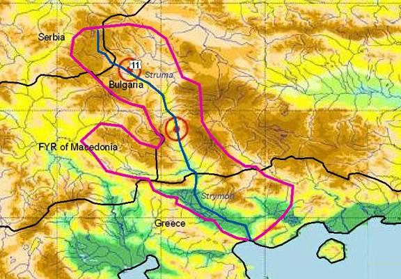
STRUMA/STRYMON RIVER Sub-basin
(sub-basin shared by Republic of Bulgaria, Greece and Rep. of FYR Macedonia) |
Strymon/Struma is a transboundary river with a catchment of 18,078 km² (290 km and 10,797 km² in southwest Bulgaria; 110 km and 7,281 km² in northern Greece), its tributaries even extending into four countries (small parts are in Serbia & Montenegro and FYR Macedonia). It has a mean runoff of 2,500 million m³/year (Greek border) and is of great importance for the irrigation of the Serres plain (100,000 ha) in Greece.
Struma river has its source in western Bulgaria at Vitosha mountain south of Sofija and runs first west through the city of Pernik (110,000 inhabitants) and then south up to the Aegean Sea at an average elevation of about 900 m a.s.l. The basin has a pronounced mountain character. A number of thermo-mineral springs along the Struma valley are of international importance.
The climate is mainly continental (discharge maxima in spring, minima in summer). In the south, Mediterranean cyclones passing through the region can bring rainfall and snowmelt; the resulting abrupt winter floods can cause a lot of damage in the Greek area.
There are 56 artificial lakes with a total volume of 141 mil m³ (largest dams are Studena, Pchelina and Djakovo) in the Struma valley built for water supply (including for Sofija), power generation and irrigation (presently ca. 50,000 ha). With decreasing industrial production as the main source of pollution, the quality of the Struma water improved. The Pchelina Dam Lake serves as a pollution sink. The section between Pernik and Radomir is highly polluted. The city of Blagoevgrad (71,000 inhabitants) is one of the major polluters (no WWTP) in the middle river section. The third major city is Kjustendil (52,000 inhabitants). |
The course of the Strymon through Greek territory is 26 km until it reaches the Kerkini Lake, the river stretch downstream up to the coast is 110 km long.
Kerkini reservoir (109 km²) was built in 1933 at a former swamp for regulating the Strymon river discharges, irrigation and flood protection (new dam in 1982). The partly shallow reservoir (4-5 m fluctuating) developed into an important wetland for migratory and breeding birds, protected under the RAMSAR Convention. |
Bulgaria |
Greece |
1.1. Geographical properties |
Longitude/latitude at downstream river outlet |
Struma sources: 42o33’ 40’’N 23o 16’ 40’’ E
Struma border: 41o 22’ 00’’N 23o 20 40’’ E
|
The Basin is located between geographic longitude 20011’E and 24034’ and geographic latitude 40047’ and 42053’. |
Size of basin |
| 10,797 km² of the basin belong to Bulgaria |
7,281 km² belong to Greece |
Length and width in km |
| The river length up the border is 290 km. (total 400 km) |
The river length on the Greek territory is 110 km (total 400 km) |
Topography, including altitude range in m |
| Struma River springs from the southern slopes of Vitosha Mountain, at an elevation of 2,180 m. Its water catchment area is of a marked mountainous nature and the average elevation is around 900 m. |
10% of the basin has altitudes from 1,100-1,400 m
30% of basin has altitudes from 750-1,100 m
30% of basin has altitudes from 500-750 m.
|
Geology |
• Mesozoic volcanogenic and sedimentogenic formations at the headwaters region of the river. Volcanic lavas of rhyolites, rhyodacites in many places of the region.
• Karst groundwaters are collected in Mesozoic carbonate rocks, occurring in the upper reaches of the Struma River, the Radomir sub-valley, and in the region of Kraishte.
|
Karstic formations |
Rainfall, average annual and seasonal distribution, etc. |
The average perennial rain flow for the catchment area is 690 mm annually (1936 - 1998).
It belongs to the transcontinental climatic sub-area from the European continental climatic area, and partly to the South BG climatic sub-area of continental Mediterranean climatic zone
|
The mean annual rainfall is around 700 mm/year |
River(s), with lengths and average annual flows and seasonal distribution - flood and drought incidence and impact |
|
|
Annual mean discharge (m³/s)
|
|
Treklyanska |
515,3 |
2,783 |
0,8 |
Novoselska |
63,5 |
0,853 |
0,4 |
Eleshitsa |
315,2 |
3,346 |
1,5 |
Sushichka |
32 |
0,685 |
0,3 |
Lebnitsa |
270,5 |
2,398 |
0,7 |
Strumeshnitsa |
1892 |
10,226 |
3,4 |
Djerman |
396,3 |
3,401 |
1,4 |
Bl.Bistritsa |
206,5 |
2,631 |
1,4 |
Gradevska |
180 |
1,791 |
1,1 |
Bistritsa |
118 |
2,903 |
2 |
|
|
|
|
|
Strymonas (main stem downstream to Lake Kerkini |
3,095 |
|
|
Ohiros |
472 |
|
|
Marmaras |
234 |
|
|
Other (incl. the reach of Neas Karvalis) |
586 |
|
|
Total |
18,078 |
|
|
Total on Greek territory |
7,281 |
|
|
Main tributaries of Strymonas river are:
Butkovas, Exavis, Krousovitis, Xiropotamos |
1.2. Demographic properties |
General location of the basin |
| In the upstream section the catchment area covers high fields and low mountains. The mid and down stream sections of the river catchment are fed from the east by the highest Bulgarian mountains of the Rila and Pirin ranges, and from the west by the so-called "Surrounding mountains". |
The boundaries of the Strymonas catchment are defined by the following mountains: Kerdilia, Krousia, Beles (western limit), Falakro, Lekani and Pageo (south-eastern limit). |
Total population in basin |
| 430,000 inhabitants |
192,828 inhabitants (census 1991) |
Population of principal cities or towns |
Radomir (15,835 inh.)
Sandanski (26,695 inh.)
Petrich (32,267 inh. )
Dupnitsa (38,323 inh. )
Kyustendil (50,243 inh.)
Blagoevgrad (71,361 inh.)
Pernik (86,133 inh. )
|
Serres: 70,000 inhabitants |
Average per capita income |
| Total household about 1,045 € (2002) |
12,000 € |
Industrial and agricultural GDP (Gross Domestic Product) (2003) |
| Not available information |
? |
Population living below the poverty line |
| Not applicable |
? |
Other relevant characteristics |
| Approximately 72 % of the total population in the river basin is connected to a sewerage system and 40 % to a wastewater treatment plant (WWTP). |
The artificial lake Kerkini is a significant wetland and was created for flood protection |
1.3 LAND USES |
| The main land uses include parkland and protected fauna/flora areas, skiing, forestry, grazing, dry and irrigated agriculture, hydroelectricity, urban and scattered industry, fish farming and ponds and coastal tourism. |
Agriculture, hydro-electricity, fish farming and tourism |
2. WATER RESOURCES / USES AND ENVIRONMENT SITUATION |
Total available surface and groundwater resources |
Mean monthly discharge for the years 1971-1998 at the Greek-Bulgarian border were ranged between 20 and 120 m³/sec
In the river valley of the Struma River there are 56 artificial lakes with a total volume of 141 million cubic meters.
|
|
Mean annual surface resources (hm³)
|
Strymonas (boundaries) |
2,613 |
Strymonas (total up-stream to Lake Kerkini) |
189 |
Aggitis (Krinides) |
608 |
Aggitis (from Krinides to the junction with Strymonas river) |
113 |
Strymonas (main stem downstream to Lake Kerkini |
869 |
Ohiros |
172 |
Marmaras |
79 |
Other (incl. the reach of Neas Karvalis) |
164 |
Total |
4,808 |
Total on Greek territory |
2,195 |
|
Net usable capacity of surface reservoirs |
| There are dam reservoirs in the river valley of Struma River used for irrigation and water supply. The major ones are Studera reservoir and Pchelina reservoir in Bulgaria |
|
|
Usable capacity (hm³) |
Lake Kerkini |
365 |
275 |
Leukogia |
|
11,956 |
Katafytos |
|
0.751 |
Folia |
|
1 |
|
Total surface water abstractions (estimated where not measured) |
58,603 m³ |
? |
Total groundwater abstractions (estimated where not measured) |
33,781 m³ |
? |
Surface and groundwater quality (in general categories only) |
? |
Surface water quality: I |
Water uses (total, by sector, principal uses, current (estimated) and future (projected), include in-stream uses (fisheries, etc.) where appropriate) |
• The irrigated areas in the Struma river valley in Bulgaria once were 63,000 hectares, and in the region in question they are presently about 50,000 hectares. A lot of pumping stations and irrigation canals were construc-ted, too.
• It is envisaged to construct new hydro-techni-cal installations such as the Topolnitsa Dam Lake and to reconstruct the water supply facilities of many towns and villages.
There are thermo-mineral and balneo-therapy facilities in the Struma valley. such as in Kjustendil, Nevestino, Sapareva Banja, Rudartsi, Pernik, Sofia and others. The thermo-mineral springs are phenomena of highest national and international significance and deserve care for preservation and enrichment |
• The irrigated areas at Strymon river in Greece are 40,000 hectares.
• Fisheries
• Industrial use
• Animal husbandry |
Deficits and other resource concerns (e.g. quality, extremes, environmental degradation) |
Due to the decrease of industrial production in the country as a whole, the quality of Struma waters, like most other BG rivers, bettered. The Pchelina Dam Lake has a beneficial effect as it retains most of the pollutants.
Many water supply systems for the towns and villages and for the industrial factories are built. The following town purifying stations for waste-water have already been built: in Kjustendil, Dupnitsa, Pernik and Sofia.
|
? |
ENVIRONMENTAL PROPERTIES |
| Protection of the national parks Rila and Pirin, and of reserves,like Julen,Hiht mountain lakes |
? |
Sensitive ecosystems, biodiversity and environmental impacts in the basin |
3. BASELINE INFORMATION AVAILABILITY |
Observation networks |
| Hydrological and meteorological observation network in NIMH_BASc, biological monitoring in process of organising |
? |
Maps, with available scales, GIS and remote sensing imagery |
| GIS –degree of generalisation 1:50 000 and 1: 100 000 |
? |
Data archives and their adequacy |
| Regular observation within the national hydro-logical and meteorological observation network |
? |
Research centres |
| National Institute of Meteorology and Hydrology in the frame of Bulgarian Academy of Sciences |
EKBY (Greek Biotope/Wetland Centre)
AUTH (Aristotle University of Thessaloniki) |
NAME AND CONTACT DETAILS OF PERSON(S) COMPLETING THIS FORM |
Prof. Roumen ARSOV
University of Architecture, Civil Engineering and Geodesy, Faculty of Hydrotechnics
1,Christo Smirnenski blvd.
1046 Sofia, Bulgaria
Tel: (+ 359 2) 9635245/ext.663
Fax: (+ 359 2) 8656648
Email r_arsov_fhe@uacg.bg
Assoc.Prof. Dr.Snejana DAKOVA
NIMH-BASc, 66 «Tzarigradsko shausse» bul
1784 Sofia, Bulgaria
E-mail Snejana.Dakova@meteo.bg
Tel ( +359 2)975 39 86 ; Fax 988 03 80 |
Prof. Jacques GANOULIS
Hydraulics Laboratory, Civil Engineering Department
Aristotle University of Thessaloniki
54124 Thessaloniki, Greece
Tel: +30-231-099.56.82
Fax: +30-231-099.56.81
e-mail: iganouli@civil.auth.gr |
Bulgaria |
Greece |
FYR Macedonia |
As only a very limited part of the basin is located in FYR Macedonia, agreements concern mainly Greece and Bulgaria. |
A small share of the Struma/Strymon sub-basin is in the FYR Macedonia, namely the Strumica river sub-basin (1,520 km²).
For infos on this area please look also on the summary table 3.10. Vardar/Axios river
|
4. MANAGEMENT SETTING |
4.1. International agreements / conventions and national legislation |
The bilateral cooperation in the use of water dates back to 1964 (first bilateral agreement on the use of Mesta River waters).
Both countries ratified the Helsinki Convention for protection and use of transboundary watercourses (1992; in GR in force since 1996) and the Espoo Convention.
After the implementation of Helsinki Convention, GR and BG are cooperating by a joint monitoring in the three common river basins, i.e. Struma, Mesta (including the tributary Dospat) and Maritsa (including the tributary Arda).
In the following years, bilateral agreements on the use of other transboundary rivers waters were signed. Also, cooperation in scientific and technical field for the best management of water resources is well established.
The main agreements on the protection and use of transboundary watercourses are:
• GR-BG agreement on co-operation for the use of watercourses flowing through the two countries (Legislative Decree 4393/1964);
• Second Protocol of the GR & BG agreement about the regulation of economic questions and development of the economic co-operation (Legislative Decree 4393/1964);
• Agreement between GR & BG concerning the formation of a joint committee for the cooperation in the field of electric energy and the use of cross-border river waters (Sofia, 1971);
• Agreement between GR & BG on scientific and technical cooperation (Athens, 1973/1976);
• Protocol for the Joint GR-BG Technical Working Group and Environment Group (approved 1990);
• Protocol for the co-operation of GR-BG Experts for flood control of Strymonas River (approved on 1980);
• Protocol of the Meeting of the Joint GR-BG Committee of Experts for the preparation of a common proposal to the EU for the joint monitoring and control of water quality and quantity of the transboundary rivers Maritsa/Evros, Mesta/Nestos and Struma/Strymonas. (1991). |
International Legal Framework:
In the Accession Agreement of 1994, Bulgaria and the EU have agreed to develop and strengthen their co-operation on environment and human health, including: monitoring and combating water pollution, sustainable development, management and protection of transboundary waters, and protection of flora and fauna. Bulgaria will adjust its legislation in order to comply with EU Directives, regulations and any other legal instrument issued by the Commission (L358/24; 31.12.94).
The Accession Agreement accepts the Helsinki Convention as one of the guiding principles for the management of Transboundary Waters. It refers to the following conventions relevant for transboundary rivers:
• the Convention on EIA in a transboundary context
• the Convention on transboundary effects of industrial accidents
• the Ramsar Convention.
In addition the following EU legislation has been taken into account when harmonising the Bulgarian National legislation in water resources management:
• Water Framework Directive (2000/60/ EEC)
• Urban Wastewater Treatment Directive (91/271/EEC)
• Dangerous Substances Directive (76/464/EEC)
• Surface Water Dir. (75/440/EEC)
• Groundwater Dir. (80/68/EEC)
• Nitrates Directive (91/676/EEC)
• Fish Water Dir. (78/659/EEC)
• Bathing Water Dir. (76/160/EEC)
National Legislation:
The following water-related legislation is currently in power:
• Law on Prevention of Air, Waters and Soils against Pollution (1963)
• Regulation 7/1986 on the criteria and norms for quality assessment of surface waters
• Environment Protection Act (Promulgated State Gazette No 86/18.10.1991,Amended 1992; 1995; 1997; 1998 and1999)
• Water Act (1969, amendment 1999, 2000, 2002, 2004)
• Regulation 6/2000 on the emission limits for admissible content of harm-ful and dangerous substances in wastewater discharging into water bodies
• Regulation 7/2000 on the require-ments for discharge of industrial wastewater into urban sewerage systems
• Regulation 10/2001 on granting permits for discharging wastewater in water bodies and on setting up individual emission limiting values for point sources of pollution
• Regulation 12/2002 on quality of surface water intended for abstraction of drinking water
• Regulation 4/2000 on water quality for fish and shellfish farming
• Regulation 5/2000 on the order and setting up of the networks and operation of the National System for Water Monitoring
• Regulation 1/2000 on the protection of groundwater.
Expert comment on the new laws:
The BG national legislation issued since 1999 is strictly harmonized with the EU water resources management. |
Actually, no major bilateral agreement for Strymon river water management is operational. No international river commission was formed.
Strymon river is included in the basic agreement of cooperation between the two countries concerning the management of transboundary waters (1964), which is today obsolete.
Although Strymon river was yet no priority for the two parties, increasing problems of sharing international waters and tensions between different water uses make the process of bilateral cooperation a high priority.
Of special interest for Greece is the management of the lake Kerkini, a water reservoir constructed near the Bulgarian border for flood retention and irrigation purposes. lake Kerkini is an impor-tant wetland for ecological reasons. No single body legally responsible for the direct local conservation of the wetland exists. The Preliminary Manage-ment Scheme is guided by a Joint Committee presided by a repre-sentative of the Ministry of Environment.
A large part of the catchment on Greek territory is designated as pSCI/SAC according to Dir. 92/43/EEC. There is also an extensive area designated as game refuge.
A new law in Hellas (L3199/03) which activates the EU-WFD should in principle regulate all necessary actions for the river management. Implementation of this process is questionable and the scheme is under review by the new government in Greece (elected in March 2004). |
4.2. Institutions / distribution of responsibilities |
The National institutions responsible for and/or taking part in water management are:
• Ministry for Environment and Water (MoEW)
• Executive Agency on Environment (EAE) at the MoEW
• Ministry of Regional Development and Public Works (MRDPW)
• Ministry of Health (MH)
• Ministry of Agriculture and Forestry (MAF)
• Ministry of Finance (MF)
• Municipalities and local water companies
• National Institute of Meteorology and Hydrology (NIMH) at the Bulgarian Academy of Sciences (BAS) |
Local Prefectures and local urban authorities are involved in different sectors for water abstraction from the river, different water uses and water quality.
Responsibilities are divided according to the specific use of water (water supply, irrigation, industry), whithout any effective coordination.
According to the new water law implementing the EU-WFD in Greece, the water management at the catchment scale should be coordinated by the respectve administrative regional authority. However, this is presently under review.
At national level, the Ministry of Environment is responsible for integrated water management. For transboundary rivers the Ministry of Foreign Affairs is also involved. Next are the Ministries of Economics, of Agriculture and of Defence to some extend. |
|
| |
4.3. Planning / Decision making processes |
Bulgaria |
Greece |
FYR Macedonia |
| All functions related to the management of the quantity, quality and protection of the natural surface, ground, mineral and thermal water and the connected active-ties (legislation, strategy, policy, monito-ring, programmes, information, control, protection and distribution of the water, norms and limits for use and protection of the water, permitting regime, investment policy and economic regulators for integrated management of the water, etc.), are carried out by the Ministry of Environment and Water.
The following legislation acts and pro-grammes are in force and under implementation:
• Water Act (1999)
• National Programme for Priority Construction of WWTPs for the Settlements with Population Over 10 000 PE (called here-after National Programme for WWTPs)
• Implementation Program for Directive 91/271/EC Concerning Urban Waste Water Treatment in Bulgaria (called here-after Implementation Program)
• National Programme for Construction of Sewer Networks and Main Trunks to the WWTPs for the Settlements with Population Over 10 000 PE PE (called here-after National Program for Sewerage)
• Ordinance for Establishing Sensitive Zones (called here-after Sensitive Zones Ordinance)
• Development of the Pilot River Basin Management Plan for the Mesta is in progress.
Other actions are based on the most urgent problems that origin from every-day life.
|
Due to low political priority, no bilateral agreement nor joint GR-BG plans for integrated water management in the Strymon/Struma basin have already been developed. For the Greek side agricultural activities are important and depend on water availability on BG side. For BG environmenttal protection, wastewater treatment plants and eco-tourism are the main priorities. There is an urgent need to establish a joint international committee for water resources management.
Parts of Strymonas catchment on Greek side are designated as NATURA 2000 sites. All relevant planning and decision-making should be carried out according to the provisions of the existing nationnal and EU legislation.
|
In the Strumica sub-basin in the FYR Macedonia, the hydrodams of Turija, Vodoca, Mantovo and Ilovica serve water supply and irrigation. Responsible institutions are the Ministry of Forestry, Agriculture and Water Economy and the Public Enterprise for Water Management with its branch office in Strumica. |
4.4. Finances |
Recent estimations show that about 3,500 Mio. EUR are necessary to be invested for development, upgrading, reconstruction and rehabilitation of the urban waters infrastructure (UWI) in Bulgaria. For development, upgrading, reconstruction and rehabilitation of the sewer networks and WWTPs only the necessary sum is about 2,200 Mio EUR. The state and the municipalities are not able to secure this sum now and in the near future. That is why support from the International Financial Institutions and participation of the private sector (foreign investors in particular) is of vital importance.
The following financial sources are definitely or provisionally considered by the government and municipalities:
• State Budget (SB)
• Enterprise for Management of Environment Protection Activities (EMEPA) at MoEW
• European Investment Bank and EBRD
• PHARE, ISPA
• Private Investors (PI) – international companies participation in the urban water infrastructure (UWI) management and development
• Bilateral financial agreements between the BG government and other European countries and banks (Switzerland, Denmark)
The private investors participation at the UWI projects in Bulgaria is expected to contribute to the vast part of the invest-ments needed. Its contribution is envisaged to reach the sum of about 2,000 Mio. EUR which is 57 % of the neces-sary total sum of 3,500 Mio. EUR.
|
No short- or medium-term investment plan for river Strymon exists. Past management activities related to the GR side of Strymon are funded by the national government and EU resources. |
|
4.5. Past and present major projects (including listing of donors’ interest) |
The following projects and research have been developed for the Struma/ Strimon river basin:
• Review of the water pollution in the transboundary river basins: Maritsa Tundja, Arda, Mesta and Struma. Phare 1999 (July). Draft Final Report.
• Dynamics of the zoobenthos of the system Struma River – Pchelina reservoir during the period 1990 –1992 Kozuharov D. 1999. - Acta Zoolog. Bulg., 2-3: 79-88.
• Correlation and regression analysis of dependence between saprobic state of Blagoevgradska Bistritsa river and sewage quantity of Blagoevgrad, Natchev, N. 1988. Hydrobiology, 33.
• Concernant le changement de l’infrastructure autour de la riviere Struma, audessous de Sandansky pendant les derniers 60 annes, Pehlivanov, L. 1996.. In: MEDIMONT-PECO Scientific Report (1st January 1995 - 31th March 1996). European Commission Project. Sofia.
• Recent assessment and long-term changes in the saprobiol. state of Struma river (south-western Bulga-ria), Soufi R, E. Varadinova, Y. Uzu-nov. 2002 - J. Envir. Prot. Ecol., 1-3: 68-75
• The macrozoobenthos of Struma river: An example of a recovered community after the elimination of a heavy industrial impact with suspend-ded materials Uzunov Y., S. Kova-chev. 1987. Arch. Hydrobiol./ Supl. 76 (Monogr.Beitr.), 1-2:169-196
• Review of the water pollution in the transboundary river basins: Maritsa Tundja, Arda, Mesta and Struma. Phare 1999 (July). Draft Final Report.
• Research Studies, Expertise and Consultations for Different Engineering Structures on the South Bulgarian Rivers: Struma, Mesta, Arda, Maritsa and Tundja, 1998 – 2002, St.Modev.
• Feasibility Study for Identification of Sensitive Areas in Mesta, Struma, Arda, Tundja and Maritza River Basins in Accordance with the Criteria of Directive 91/271/EEC, 2003, LDK Consultants, Engineers and Planners, Athens, MoEW – Project BG No 9904-04.02
• Review of Water Pollution in the Cross Border Region of South Bulgaria, PHARE Programme, Carl Bro Group, July 1998.
• In addition, five wastewater treatment plants (WWTP) have been built in the Struma river basin at the towns of Pernik, Radomir, Kyustendil, Doupnica and Zemen. |
• A bilateral project started in the 90’s to check compatibility of recording stations located on both sides of the border for monitoring the water quality of Strymon river.
• Research of a software package for water quality simulation. A new project started in 2002 for the integrated management of water resources on the Greek part of the basin “Ecosystem-based Water Re-sources Management to Minimize Environmental Impacts from Agriculture Using State of the Art Modelling Tools in Strymon River Basin” (LIFE03 ENV/GR/000217
• There is an overlapping of different projects financed from national and EU funding. Most of the projects have no international involvement and until now donor’s interest was not attracted.
|
In the FYR Macedonia, this catchment has been included into the Project on Irrigation, Rehabilitation and Restructuring, financed by the World Bank (WB 0018). |
4.6. Stakeholder Participation |
| According to the National legislation every significant activity (and water and environment related ones in particular) are subject of discussing eventual correction and approval by the affected sides – municipalities, citizens and industry, following definite procedures. Development of an Environment Impact Assessment is required, according to the procedure, which is discussed and eventually corrected by the stakeholders. |
Though many of the management and conservation projects in the area are quite well defined, stake-holder participation was never one of the priorities.
The first effort for stakeholder par-ticipation was within the project Integrated Management of Euro-pean Wetlands (IMEW) (FP5, DG Research) with Danube Delta National Institute for R&D, Finnish Game and Fisheries Research Klaipeda University of Lithuania, University of Durham, Env. Education Centre of Kordelio, Thessaloniki.
In the most recent LIFE Environ-ment project, stakeholders are involved directly from the onset.
|
|
4.7. Awareness / Communication |
Almost all projects and activities related to water and environment in the Struma river basin face public awareness. The only exeption is the “Djerman-Skaka-vitza” Project in 1995 (part of the “Rila” Project), which received strong local public opposition.
Communication between responsible institutions, stakeholders and the society is good and in accordance to the national legislation.
|
• Very limited or inexistent
• An information centre for the coastal zone of Strymonikos Gulf is operating by the local authority.
|
|
5. CONCLUSIONS / RECOMMENDATIONS |
5.1. Identification of critical problems (transboundary situation)
- problems related to the resource
- problems associated to uses, needs and demands
- problems affecting ecosystems
|
Bulgaria |
Greece |
FYR Macedonia |
Problems, related to water resources:
• Global climate change affected the region over the last 20 years, resulting in a ca. 30 % decrease of precipitation and associated water resources.
• Transboundary river water resource distribution between BG and GR are for years subject of negotiations. It seems now that a reasonable agreement has been achieved.
Problems, associated with the uses, needs and demands:
• A shortage of water for drinking and irrigation exists in some settlements and regions.
• Construction of dams is necessary in order to regulate the runoff and to assure the necessary water quantity during the year.
Problems affecting ecosystems:
• Construction of WWTPs is necessary for most of the towns downstream the main river course and for some industrial enterprises in the basin.
|
The river enters Greece carrying various pollution loads from several important urban and industrial centres, a significant number of mines, and intensive agriculture in the surrounding area.
It also suffers from bank erosion due to illegal quarrying of gravel and sand, receives a high quantity of material and is threatened by sedimentation.
Bulgaria has implemented some measures for the reduction of sedimentation.
There is also a high risk of flooding, as water level in lake Kerkini varies during the year.
Along its course on GR territory, the river receives wastewater from surround-ding settlements, agricultural run-offs and effluents from stock breeding units.
It is urgent to complete wastewater treatment stations and proceed to reduce and manage diffuse pollution mainly from agricultural sources.
|
The main problem in the FYR Macedonian region is water shortage due to the climate characteristics, very low awareness of the water costs (very low payment of the used water, especially in the irrigation sector). |
5.2. Main achievements |
• Centralized water supply system for more than 98 % of the population
• Regular and long term monitoring of river water quantity and quality as a part of the national monitoring network. Part of it belongs to the EUROWTERNET.
• Establishing special monitoring stations at the both sides of the state border between BG and GR.
• Inventory of water pollution sources and loads
• Establishment and maintenance of river water quality categories along the river reaches.
• Establishing a River Basin Directorate and an associated River Basin Council, according to the national and EU legislation.
• Existence of a Regional Inspectorate of Environment and Water
• Established “sensitive” and “less sensitive” zones in the river basin
|
• Generally the bilateral political relationships are good.
• BG is an accession country to the EU and has obligations to follow the EU standards. This may facilitate the establishment of common agreements with GR.
• A water quality monitoring network is operating and many water quality factors are being recorded. |
|
5.3. Key challenges |
• Construction of WWTPs at the settlements over 100,000 PE (by 2011) and over 2000 PE (by 2015)
• Development of a River basin Management Plan (by 2009) according to the Water Act and EU WFD.
|
• An integrated approach of all environmental, political, social, economic and technical aspects of water resources management is needed in order to ensure water preservation and environmental integrity of the region.
• Flood alleviation
• Modernise irrigation systems
• Wetland functional analysis.
• Wetland function' socioeconomic evaluation.
• Stakeholder information and effective participation.
|
|
5.4. Donor interests |
| The necessary major investments in the water sector in the region is expected to come from international sources and mainly from EU preaccession funds (ISPA programme – by 2007), cohesion and structural funds (after 2007), etc. |
It is unlikely to attract any international donations to support management actions for the river without showing plans, priorities and cooperative synergies. |
|
5.5. Recommended priority actions |
• Construction of WWTP at the towns of Blagoevgrad, Petrich, Sandanski and Kresna.
• Development of a River Basin Management Plan
|
• Water supply regulation on both sides
• Cease dumping of solid wastes and wastewater on BG side
• Wastewater treatment in the nearby urban areas.
• Creation of an early-warning system for sudden pollution and flood events.
• Complete and maintain a data logger network to monitor water quality.
|
|
6. MAIN REFERENCES, BACKGROUND DOCUMENTS |
Water Act (1969 amended 1999 - 2004)
Regulations, associated with the Water Act (1999) – 12 in number
National Strategy for Development and Management of Water Resources (2004)
Implementation Program for Directive 91/271/EC Concerning Urban Wastewater Treatment (2003), MEW, Sofia
National Program for Construction of Sewer Networks and Main Trunks to the WWTPs for Settlements with Over 10 000 PE (2001), MRDPW, Sofia
National Program for Priority Construction of Urban Wastewater Treatment Plants for Settlements with Over 10 000 PE (1999), MEW, Sofia
Ordinance for Establishing of Sensitive Zones (2003), MEW, Sofia |
• Papers, books and publications from AUTh and DUTh.
• NATURA 2000 national data base
• Greek Biotope/Wetland Centre records
• Intl. Workshop on Integrated Management and Protection of Transboundary rivers and wetlands, Wetlands International, 24-26 June 1999, Wagenigen, NL |
|
|