| 1. |
GENERAL INFORMATION |
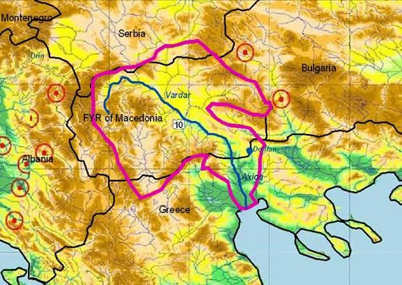
VARDAR / AXIOS RIVER Sub-basin
(sub-basin shared by FYR Macedonia and Greece) |
Vardar river flows into the North Aegean Sea as Axios river in Greece (87 km long, extending over 3,212 km²) and covers 23,747 km2 (86.9%) of FYR Macedonia; small catchment parts are further in Serbia & Montenegro. Vardar is the longest and largest river of FYR Macedonia (302.6 km), with an average elevation of the basin at 793 m (the Vardar spring in the Shara massif near Vrutok/Gostivar is at only at 683 m), at average rainfalls of 660 mm and a total annual discharge of 4.56×million m³. Its floodplain is mainly used by agricultural use (including cattle-breeding). The capital of FYR Macedonia and several big industrial cities with a total population of over 1 million are located in this area: Gostivar (100,000 inhabitants), Tetovo (180,000) Skopje (570,000), Veles (70,000) and Gevgelija (40,000 inhabitants; at the Greek border), including several large units of chemical industry. Treska, Pchinja, Bregalnica, Crna, Lepenec and Babuna rivers form sub-basins of the Vardar. 19 large and over 100 small dams and reservoirs have been constructed in this region.
Axios is also one of the most important transboundary rivers in Greece, mainly because of the use of waters for irrigation in the fertile plain of Thessaloniki. The river forms a very rich ecological delta (protected RAMSAR site) before discharging into the Bay of Thermaikos.
The population activities on Greek side are mainly agricultural, heavily depending on the river flow (varying from 10 m³/s to 1,425 m³/s). The maximum flow rate was greatly reduced during recent years, mainly due to the construction of retention reservoirs and irrigation works upstream in FYROM. There is yet no bilateral cooperation agreement for sharing the international waters of Axios River.
The city of Thessaloniki is located east of the lower river. For this second-largest city of Greece (population over 1 million) an initial plan for sewage disposal in the lower Axios was completely modified in order to protect the water quality and ecosystems. Thessaloniki’s sewage, after secondary treatment, is discharged into the sea through a submarine short outfall.
|
FYR Macedonia |
Greece |
1.1. Geographical properties |
Longitude/latitude at downstream river outlet |
It is located between 40° 51' 16" and 42° 22' 21" north geographic latitude and 20° 27' 32" and 23° 02' 12" east geographic longitude.
Vardar Gevgelija: 41° 08' 48" / 22° 31' 50" |
|
Size of basin |
20,535 km² |
3,212 km² |
Length and width in km |
301 km in FYR Macedonia (total: 388 km) |
87 km in Greece (total: 388 km) |
Topography, including altitude range in m |
The relief in the catchment is predominantly hilly-mountainous and very varied with average elevation of 793 m. High mountains in the northwest reach altitudes of more than 2,500 m and about 2,000 in the eastern part. Valleys’ altitudes range from 750 to 50 m above see level. |
The western and southwestern part of the catchment is mountainous and the highest altitude is about 2,400 m, whereas at the eastern boundary altitudes reaches 1,800 m. Altitudes in the river valley vary from 250 to 750 m, and the delta area in the Greek side ranges between 0 and 250 m. |
Geology |
The territory of FYR Macedonia belongs to two regions; Rodopian region of ancient mountains and ravines located in eastern part of the country and a region of young (recent) mountains and ravines located in western and central part. |
Palaeogene flysch, limestone, schists and igneous rocks of Axios and Circum Rhodopic zones |
Rainfall, average annual and seasonal distribution, etc. |
Different types of climate characterize Mace-donian territory: continental, changed continental, sub-Mediterranean (changed maritime), mountainous climate, as well as their various sub-types.
The average annual air temperature vary bet-ween 12°C to 14°C in the region with a sub-Mediterranean climate, 10°C to 11°C in the region with a hot continental climate, 5°C in the region with a sub-alpine mountainous climate, and 0°C in the region with an alpine mountainous climate.
The annual precipitation ranges between 500 mm in the central part to more than 1,000 mm in west average between 600 to 900 mm. |
The climate can be characterized as continent-tal in the northern part of the catchment and Mediterranean towards the coastal zone. Mean annual air temperatures vary between 9 °C and 17.5 °C, while annual rainfall ranges from 400 mm to 1,300 mm. |
River(s), with lengths and average annual flows and seasonal distribution - flood and drought incidence and impact |
Total annual average flow is estimated to be 4 289 x 106 m³/per year.
Table 1. Hydrographic characteristics of Vardar river basin with major tributaries
River |
А
[km²] |
Hav
[m] |
Lr
[km] |
Q
[m³/s] |
V
[m³]106 |
Vardar |
22,456 |
793 |
301.6 |
44.9 |
4,564.35 |
Treska |
2,068 |
1,01 |
138.3 |
24.2 |
762.3 |
Pcinja |
2,840.7 |
758 |
136.4 |
2.6 |
396.9 |
Bregalnica |
4,306.8 |
722 |
225 |
4.1 |
444.15 |
Crna |
5,89 |
863 |
228 |
7.4 |
1,178.1 |
|
Mean annual water discharge: 5*109 m³/y
Main tributaries of Axios river:
Gorgopis 70 km
Vardarovasi 102 km |
1.2. Demographic properties |
FYR Macedonia |
Greece |
General location of the basin |
FYR Macedonia is situated in the central part of the Balkan Peninsula. Vardar River belongs to the Aegean Basin, which covers an area of 22,319 km2 or 87% of the Country territory. |
The Greek part of the the Axios basin is located in the central part of the province of Macedonia. The river enters the Greek territory at Euzonous, passes through the valley of Thessaloniki and discharges in the Thermaikos gulf. |
Total population in basin |
1.8 Million |
1.6 Million |
Population of principal cities or towns |
Skopje: 600,000 inh. |
Thessaloniki: 1,400,000 inh. |
Average per capita income |
No separate economic data for the Vardar River catchment are available |
13,000 € |
Industrial and agricultural GDP (Gross Domestic Product) |
238.7 billion MKD (4 billion €) in 2002 |
|
Population living below the poverty line |
NA |
|
Other relevant characteristics |
As country in transition FYR Macedonia faces serious economic problems. |
Axios is very important for the agricultural and industrial development of the central part of the province of Macedonia. |
1.3 LAND USES |
No separate data for the Vardar River catchment are available. the percentages shown below represent the whole territory of the country:
Land use distribution |
Total land % |
Total land |
100 |
1. Productive land |
90.92 |
1.1. Forest land |
40.15 |
1.2. Agriculture land |
50.77 |
1.2.1. Pastures |
24.91 |
1.2.2. Arable land |
25.86 |
1.2.2.1. Ploughed lands and gardens |
21.79 |
1.2.2.2. Orchards |
0.77 |
1.2.2.3. Vineyards |
1.15 |
1.2.2.4. Natural meadows |
2.15 |
2. Other land uses |
9.08 |
2.1. Water and water streams |
1.73 |
2.2. Natural lakes |
1.71 |
2.3. Religion objects |
0.05 |
2.4. Roads and railway-tracks |
1.34 |
2.5. Settlements |
1.38 |
2.6. Other unproductive land |
2.87 |
|
? |
FYR Macedonia |
Greece |
2. WATER RESOURCES / USES AND ENVIRONMENT SITUATION |
Total available surface and groundwater resources |
14.6 x 10⁹ m³ from rainfall (with a 707 mm average rainfall)
0.604 x 10⁹ m³ inflow from upstream countries
0.52 x10⁹ m³ groundwater resources;
4.8 x 10⁹ m³ runoff
Runoff coefficient 0.33 (territory of Rep.Maced.) |
|
Net usable capacity of surface reservoirs |
15 large and over 80 small reservoirs have been constructed in Vardar River basin, with a total volume of over 1 million m3 usable storage |
|
Total surface water abstractions (estimated where not measured) |
320 x 106 m3 water supply
400 x 106 m3 other water needs |
|
Total groundwater abstractions (estimated where not measured) |
258 * 106 (estimate) |
|
Surface and groundwater quality (in general categories only) |
The quality of surface water in the water-courses does not always comply with the relevant prescribed regulation, and it is most frequently in the range of class 2-3, and in certain downstream sections even in the 4th class. The water quality in the upper parts of the rivers only can be classified as a 1st class water. The pollution of surface water is mostly a result of low percentage of communal wastewater treatment.
The quality of groundwater in general is very good. Often it is used for water supply with no or very little treatment. Pollution of shallow groundwater in some areas in the valleys occur due to poor sanitation and due use of chemicals in irrigated agriculture. |
The surface water quality has been classified as good/moderate at some points along the Axios river except Akropotamos, Polykastro and at the outfall of the river where the water quality has been classified as poor. |
Water uses (total, by sector, principal uses, current (estimated) and future (projected), include in-stream uses (fisheries, etc.) where appropriate) |
Water is abstracted from the Vardar for irriga-tion (63%), fish ponds (11%), drinking water (12%), municipal and industrial uses (15%), agriculture, and there are hydro-electric power stations at several reservoirs in the river basin |
- Urban, agricultural and industrial supply
- The rational distribution of water has been achieved by the construction of a dam near Prochoma with a maximum irrigation capacity of about 35,000 ha.
|
Deficits and other resource concerns (e.g. quality, extremes, environmental degradation) |
NA |
Maximum total phosphorous concentrations in the river water occur during the months of low flow, whereas, maximum nitrogen levels occur in autumn due to increasing discharge. |
ENVIRONMENTAL PROPERTIES |
Sensitive ecosystems, biodiversity and environmental impacts in the basin |
- Pollution by organic matters, heavy metals, pesticides, toxic and organic compounds. The pollution is high downstream from towns where the industries are located, due to the discharging of wastewaters (industrial and communal) into rivers without treatment.
- The decrease of Dojran Lake surface and the simultaneous deterioration of the water quality had serious ecological impacts.
|
- Pollution: Municipal wastewater and solid wastes, industrial wastewater, agricultural point source and non-point source pollution, transboundary pollution.
- Other anthropogenic activities: Drainage, gand filling, establishment of new housing facilities or expansion of old ones, Irrigation schemes, establishment or expansion of cultivated fields, establishment or expansion of livestock facilities, illegal or non.
|
3. BASELINE INFORMATION AVAILABILITY |
FYR Macedonia |
Greece |
Observation networks |
- Responsible institution for hydro-meteorolo-gical observation and monitoring is the Administration for Hydro-meteorological Works, under the Ministry of Agriculture, Forestry and Water Economy
- 16 main (two of them are airport meteorolo-gical stations), 21 regular, 26 phenological, one aerological, six hail suppression centres, and up to 200 precipitation stations. It should be mentioned that out of 34 basic meteorological stations 24 have reduced (insufficient) series of data.
- Hydrologic observations are carried out by surface water stations (110) and groundwater stations (115).
|
2000 – 2001. PartoftheDAC - OECDproject “Transnational co-operation for the protection and management of the River Axios; FYROM – Greece”. The project was undertaken by the NGO Ecological Movement of Thessaloniki. For more information visit http://www.disabled.gr/ecology/english.html or http://river.bio.auth.gr/labrivers/ |
Maps, with available scales, GIS and remote sensing imagery |
- Topographical maps 1: 25,000; 1:50,000 (+GIS DTM from maps1:25,000)
- Geological 1:200,000
- Hydrogeological: 1:200,000 (in preparation 1:25,000)
- Agriculture land (cadastral plans) 1:5,000
- Urban areas 1:2,500 and 1:1,000
|
|
Data archives and their adequacy |
Data archives exist in relevant governmental institutions and research institutes, Ministry of Environment, Administration for Hydrometeorological Works within the Ministry of Agriculture, Forestry and Water Economy. |
Monitoring systems from information related to their availability to the public are inadequate, inaccurate, non reliable, not consistent and deficient in general |
Research centres |
Faculty of Civil Engineering, Skopje
Civil Engineering Institute of FYR Macedonia(GIM), Skopje
Geohidroproekt –Skopje
Administration for Hydrometeor. Works Skopje |
EKBY (Greek Biotope/Wetland Centre)
Aristotle University of Thessaloniki |
NAME AND CONTACT DETAILS OF PERSON(S) COMPLETING THIS FORM |
Cvetanka Popovska,
University St. Cyrril and Methodius – Skopje, Civil Engineering Faculty- Skopje; popovska@gf.ukim.edu.mk
Vladimir Stavric
UNDP, NCSA Project manager
vstavric@mt.net.mk |
Prof. Jacques GANOULIS
Hydraulics Laboratory, Civil Engineering Depart
Aristotle University of Thessaloniki
54124 Thessaloniki, Greece
Tel: +30-231-099.56.82
Fax: +30-231-099.56.81
e-mail: iganouli@civil.auth.gr |
FYR Macedonia |
Greece |
4. MANAGEMENT SETTING
4.1. International agreements / conventions and national legislation |
There is no bilateral agreement between Greece and Albania for river management but a Memorandum of Understanding to develop a joint Agreement on Water Economy from 2003 (bilateral negotiations then started).
Convention on the Protection and Use of transboundary rivers and lakes, Helsinki [1992]
Espoo Convention (ratified by both sides). |
International Legal Framework:
FYR Macedonia has taken over all legal obligations and international commitments as a successor of the former Yugoslavia, as well as new ones by becoming party of the UN and of various Conventions.
- Convention on Environmental Impact Assess-ment in a transboundary context (Espoo, 1991). Ratified by RM in 1999.
- Convention on Biological Diversity (Rio). Ratified by RM in 1997. In force since 1998.
- Convention on Wetlands of International Importance, especially waterfowl habitats. Regula-tion on ratification adopted (Official Gazette of SFR of Yugoslavia, No.9/77). FYR Macedonia became party of Convention with succession act and with the nomination of Prespa Lake in the Ramsar list in 1995.
- Convention on the Conservation of Migratory Species of wild animals. Ratified by RM in 1999. In force since November 1999.
- Convention on the Conservation of European Wildlife and Natural Habitats. Ratified by RM in 1997. In force since April 1999.
- Convention for the Protection of World Cultural and Natural Heritage. Ratified by SFR Yugoslavia in 1974.
- Convention on Access to Information, Public Participation in Decision-making and Access to Justice in Environmental Matters. Ratified by RM in 1999.
- UN Convention to Combat Desertification in Countries Experiencing Serious Drought and/or Desertification, Particularly in Africa. Ratified by RM in 2002.
The EU Water Framework Directive is a guiding principle for streamlining the water related legislation. Regarding this up to now new laws have been adjusted or elaborated for: environment, air, waste, nature and waters.
Bilateral agreements exist with Greece (between the Ministries of Water Economy). However, for various reasons, the cooperation does not function recently and has to be re-established.
The Ministry of Environment and Physical Planning has signed bilateral agreements for cooperation on environmental issues with neighboring countries, Albania, Bulgaria, Serbia & Montenegro and Greece (not ratified yet)
National legislation and documents:
- Law on Environment and Nature Protection and Improvement, Official Gazette of RM, No. 51/00 (revised version)
- Law on Water, Official Gazette of RM, No. 4/98 (rev.2004)
- Law on Communal Works, Official Gazette of RM, No. 45/97 (revised, 2004)
- Law on Hydrometeorological Matters, Official Gazette of RM, 1992 (revised, 2004)
- Law on Waste, Official Gazette of RM, No. 37/98 (rev. 2004)
- National Environment Action Plan, Ministry of Environ-ment and Physical Planning, 1997 (under revision)
- Water Economy Master Plan, Public water Economy Enterprise, 1974 (under revision)
- Physical Plan of FYR Macedonia, Spatial Planning Management, 1998, revised in 2004
- National Human Development Reports, UNDP, 2001
Expert comments on the new laws:
The new Law on Water is based on the present EU Water Framework Directive (EU/60/2000); One of the basic reasons for proposing the adoption of the new Law on Water management is the absence of an integrated approach to the regulation of water management issues, as well as an inadequate and inappropriate institutional set up.
The new Law on Communal Works regulates the works on communal infrastructure. As primary structures, beside others, sewer systems and waste water treatment plants have been included.
The new Law on Waste sets out the manner and conditions for waste collection, transport and processing, and waste disposal on landfills, landfill maintenance and waste transport. The provisions of this law apply only to the given categories of waste (communal solid waste, technological waste, hazardous waste, inert waste, special waste, and harmful substances). The law sets out also the responsibili-ties and duties of involved institutions in waste manage-ment, planning and improving the existing practice.
The new Law on Hydrometeorological Matters regulates hydrological and meteorological matters and designates the Hydrometeorological Service/Institute (HS) as responsible institution for development and maintenance of hydrological and meteorological observation; research of atmosphere, soil, and water resources; and application of hydrology and meteorology.
The new Law on Waste Management is in the course of preparation/adoption and is expected to enter into force in fall 2004. This law is much more comprehensive and con-tains sections on Plans and Programmes for Waste Manage-ment; Waste Treatment; Treatment of Non-hazardous Waste; Treatment of Hazardous Waste; Landfills; Waste Burning and Incineration; Import, Export, and Transit of Waste over the territory of FYR Macedonia; Data Monitoring and Engagement; Information System; Financing; Control and Authorized Body; Penalty Provisions. |
Unfortunately, a suspicious political climate between Greece and FYROM during the last years did not offer a possibility for establishing effective bilateral agreements of cooperation on the water management of Axios river. This political climate is recently very much improving.
The river is bound to the Conven-tion for protection and use of the transboundary water currents and the international lakes (1992) and the Espoo Convention, which was ratified by the two sides.
There are few formal agreements or arrangements on water management between FYR Macedonia and Greece. All these agreements were concluded in the past and are not operational.
1. An agreement (on provision of certain minimum flows across the border at Gevgelia during summer months) was made between the two countries on objectives of a joint development study of the Vardar/Axios River has lapsed with the failure to agree the outcome of the studies (1978).
2. Temporary agreement between Greece and FYROM for the Axios River, 1995: Not in use.
3. Axios Delta: This is a wetland of international importance in accor-dance with the Ramsar Convention (registered jointly with Loudias estuary, Aliakmonas Delta and Alyki Kitrous Lagoon) as a Special Protection Area. 79/409/EEC: Regulation on threshold values for harmful substances in effluents, game refuge, prohibition of logging.
Reference in International Euro-pean biotopes/wetlands catalogues (Important Bird Area ICBP-IWRB, CORINE Biotopes), Delineation and management studies, Ecological studies, Public awareness programs.
A new law in Greece (L3199/03) aims to activate the application of the EU-WFD in the Axios river basin.
The organisational structure for integrated water management at both national and local levels is presently under review. |
FYR Macedonia |
Greece |
4.2. Institutions / distribution of responsibilities |
- Ministry of Environmental and Physical Planning (for environmental protection and physical planning)
- Min. of Water Economy, Forestry and Agriculture (for Water Economy Master Plan and physical planning)
- Ministry of Foreign Affairs (for agreements on transboun-dary waters)
- Ministry of Health (for monitoring and standardizing the drinking and bathing water quality)
- Ministry of Economy (for mineral and groundwater resour-ces and hydro-power production)
- Hydro Electric Company HPC (original name “Elektrosto-panstvo na Makedonija”-ESM) (for hydro-power production)
- Ministry of Transport and Communications (for municipal and industry water supply)
- Ministry of Finance (for planning and the national budget)
- Min. of Local Self-Government (for local development)
- Water Economy Administration, within the Ministry of Water Economy, Forestry and Agriculture (for the policy on water use and provision of funding for project realiza-tion)
- Public Water Enterprise “Vodostopanstvo na Makedo-nija” with its 23 branches – Water Management Organizations (WMOs) (for irrigation, drainage, river regulation, torrent control and erosion protection)
- Hydrometeorological Service, under the Ministry of Water Economy, Forestry and Agriculture (regarding hydromete-orological measurements, establishment and mainte-nance of the stations)
|
At local level:
The Prefecture of Thessaloniki and the Regional Authority of the province of Central Macedonia are involved in different water management projects and actions.
For the water quality management, a new management body (Foreas Diachirisis) has been formed recently following the demands of the Dir. 92/43/EEC. This agent is now fully responsible for the inte-grated management of the Axios delta area.
At national level:
The Ministry of Environment, the Ministry of Agriculture and the Ministry of Economics are respon-sible. Because Axios is a trans-boundary river, the Ministry of Foreign Affairs is also involved. |
4.3. Planning / Decision making processes |
The planning and decision-making processes are within the sub-basins (smaller river basins) between the Ministry of Agriculture, Forestry and Water Economy (responsible for irrigation and water supply) and the Ministry of Economy-Electric Power Company EPC (responsible for hydro-power production). Beside coordination between these two institutions, there is no joint management. Actually, the “power struggle process” is very often recognized as a decision-making process. The reason for this is probably a better institutional organization of EPC than of the Water Economy Organizations (WMOs). In general, the planning in the basin is according to the existing Water Economy Master Plan (1974) that is under revision and innovation. So, common planning and decision-making in the basin is poor at the moment, although considerable efforts on problem definition are undertaken. |
A study on integrated water mana-gement is under development from the Greek side.
No effective coordination exists between different local authorities and between responsible Ministries at national level.
Almost the entire Axios catchement on the Greek side is designated as NATURA 2000 site, so all planning and decision-making should be carried out according to the provisions of the relevant national and EU legislation. |
4.4. Finances |
The major financial resources in the past were:
- World Bank: since 1998
- German Government, KfW Bank, since 1994
- EC (PHARE, Cards, TACIS and CEE): since 1994
- Swiss Government: since 1995
- Dutch Government: since 1995
- Chinese Government: since 1994
- Japanese Government: since 1994
|
Most of the studies and management actions are funded by EU resources and national funds (Interreg projects, Phare programme). |
FYR Macedonia |
Greece |
4.5. Past and present major projects (including listing of donor interest) |
Vardar is the major river basin in FYR Macedonia both in its catchment (covering almost the entire country) and its water quantity. All social and economic life is happening there. Over the last decade, over 200 projects have been performed in this region, some of high importance and some being small with local benefits. The list below gives the recent major projects.
- Irrigation Rehabilitation and Reconstructing Project: Project management unit at the Ministry of Water Economy, Forestry and Agriculture (financed by the World Bank). The main objective is to enable private farmers to better use the agricultural potential by rehabiliting and better managing the irrigation systems (Tikvesh, Bregalni-ca and Polog).
The project period (1998 – 2002) was extended to 2006. Total funding is 32.5 million US$, co-funded by: World Bank (12.5 million US$ credit and loan), Intl. Development Association IBRD/IDA (12 million US$ grant), Government of FYR Macedonia (8 million US$) and Dutch Government (12 million US$ grant).
- Municipal and Environmental Action Programme (2000 – 2004): The total funding is 10.68 million US$ (Swiss Government, Contract CHE 0031).
- Environmental NGOs Support Programme (1997 – 2003). Total funding is 1.31 million US$ (Swiss Government, Contract CHE 0028).
- River Monitoring System (2000-2002): Total funding is 633,000 US$ (Swiss Govmt., Contract CHE 0029).
- Construction of Hydro Power Plant “Kozjak”. Project started in 1994, still going on. Total funding is 80.93 million US$ (credit of the Government of China, Contract CHI 0002).
- Rehabilitation of Dams (1996 – 2000). Total funding: 3.136 mil. US$ (German Gvmt., Contract DEU 0011).
- Increasing the Agricultural Production in the Tikvesh Region (1994 – 1995). Total funding is 2.5 million US$ (German Government, Contract DEU 0014).
- Automatic monitoring stations along River Vardar for pollution observation (1997). Total funds: 1.6 million US$ (Contract PHAR 0024)
- Improving Management of Transboundary Water Resour-ces. Total funds 1 million US$ (CARD0056)
- Support of Water Resources Management (1997 – 2002): Total funding is 2 million US$ (German Government, Contract DEU 0027).
- Environmental Programme and Fund (COP 1997). Started in 1998 (still going on). Total funding is 2 million US$ (Contract PHAR0007)
- Agriculture Aid Package (COP 1996). 1997 – 2000: Total funding is 2 million US$ (PHAR0013).
- Land Policy and Cadastre - Phase I (COP 1996). 1997 – 1999: Total funding: 0.7 mil. US$ (Contract PHAR-1501).
- Land Policy and Cadastre - Phase II (COP 1996). 2000 – 2001: Total funding: 1.2 mil. US$ (Contract PHAR-1502).
- Real Estate Cadastre and Registration (2004 – 2005): The total funding is cca 500,000 US$ (Japanese Govern-ment, Contract JPN 0073).
- Lisiche Dam with Supporting Facilities (2002 - 2005): Total funding is 9.8 million US$ (Government of FYR Macedonia, national budget, Contract MK 0001).
- Water Supply and Sewerage Project. Started in 2001 (no data when it is planned to finish). Total funding is 33,1 million US$ (World Bank, Contract WB 003).
- Integrated Waste Water Treatment and Monitoring System at “MHK Zletovo” in Veles. Project started in 1997, not finished yet (MHK ZLETOVO was closed due to air pollution of Veles). Total funding is 0.3 mio. US$ (Japanese Government, Contract JPN 0010).
- Waste Water Treatment Plant in Makedonski Brod. Phase I in 1998 (total budget 55,000 US$). Phase II since 1999 (total budget 1,44 million US$). Phase III of the project (total budget 72,000 US$). Contracts: AUT 0008, AUT 0010 and AUT 0021.
- Monitoring of the Rivers in FYR Macedonia (2000 – 2003). Total funding is 1.8 million US$ (Swiss Government, Contract CHE 0007).
- Rehabilitation of the Vranista Waste Water Treatment Plant, Supply of Equipment and Support Documentation (2003): Total funding is 491,000 US$ (German Government-GTZ, Contract DEU 0074).
- Rehabilitation of Industrial Wastewater Treatment Plant- PSO 00MA/2/20 (2000 – 2002). Total funding is 726,000 US$ (Dutch Gvmt., Contract NLD 0019).
- PIP PPF Investment Option in Water Sector (2002). Total funding is 600,000 US$ (Contract PHAR1204).
- PIP PPF Feasibility Study of Dosnica Project (2001): Total funding is 143,000 US$ (Contract PHAR1205).
- Support for preparing and implementing the Local Ecological Action Plan (LEAP) for Skopje (2001 – 2004). Total funding is 306,000 US$ (German Government, Contract DEU 0078)
|
1. An allocation of EUR 1.6 million was provided under the 1997 PHARE Cross Border Co-operation Programme FYROM/Greece (Sub-project MA 9707-02 “Environmental Protection”) for a project called “Automatic Monitoring Stations Downstream the Vardar River to Monitor Pollution Quantities by Various Parameters”. The project’s objective is to provide for a conti-nuous monitoring of the pollution status and open the possibility of rapid action against potential polluters. On the basis of the information that the project will be able to provide, the Ministry of Environment of FYROM is suppo-sed to take the consequent measu-res to solve the pollution of the river.
2. In the 1997 national PHARE programme for FYROM, 2 projects were financed (for a total contribu-tion of EUR 2 million): (i) “Institu-tional Strengthening and Capacity Building” and (ii) “Waste water, water quality and solid waste management”. The objective of the first project was to assist the Ministry of Environment in establi-shing proper capacity to deal with environment protection, including water protection. The project will assist the adaptation of national legislation to the Water Quality Framework Directive and the Inte-grated Pollution Prevention and Control Directive. Out of six com-ponents of the second project, three have dealt with water protecttion e.g. National Waste Water strategy development and Waste Water Management system for Skopje. All the strategy is based on the development of the protection of particular watersheds that finally influence the main collector of Vardar/Axios river.
3. An additional allocation of EUR 3 million was provided under the 1999 national PHARE Programme for FYROM to finance the following two projects: “Strengthening to the Ministry of Environment to adapt environmental legislation to the Community acquis” and “Environmental awareness raising, impro-vement of communication and environmental monitoring”.
4. A DAC – OECD Project (2001-2002, Greek Ministry of Environment): “Transboundary cooperation for the protection and management of Axios river” The project was undertaken by the NGO Ecological Movement of Thessaloniki.
http://www.disabled.gr/ecology/english.html or http://river.bio.auth.gr/labrivers/ |
FYR Macedonia |
Greece |
4.6. Stakeholder Participation |
The most important stakeholders in the region are: Electric Power Company of FYR Macedonia (EPC), Water Economy Management Organizations (WMOs), and Local Self Government (LSG), farmers, business companies and NGOs |
Though many of the management and conservation projects in the area are quite well defined, stake-holder participation never was one of the priorities.
However it is only lately that stake-holder participation is gaining ground. |
4.7. Awareness / Communication |
The activities within the projects listed in 4.4 have much increased the environmental awareness and communication of the different institutions in this region.
The Vardar River basin is vulnerable to climate change and human activities. Acknowledging the significance of the climate change and the necessity to undertake effective actions for its mitigation, FYR Macedonia ratified the UNFCCC (1997). FYR Macedonia’s First National Communication on Climate Change (2003) is the very first national report on the country’s conditions regarding climate change issues. Communication was developed in the framework of GEF activities.
Public awareness is one of the most important approaches to support the climate change strategy and policies especially in water resources and hydrology sectors. The Climate Change Project Office at the Ministry of Environment and Physical Planning has performed many activities, such as two months public awareness campaign, five workshops on climate change-related topics, publishing of bilingual (ENG-MK) CD-Rom of First National Communication.
The Regional Environmental Centre Country Office carried out two energy related projects (2000-2001): “Improving Energy Saving and Energy Efficiency in FYR Macedonia”, funded by the Japanese Special Fund and “Energy Saving in Mace-donian Industry”, funded by Dutch Ministry of Econ. Affairs. |
Only few actions took place until now to raise public awareness. For providing information to the public, a centre was created in the delta region of Axios: “Wetland Information Centre of Axios-Aliakmon Delta, Loudias Estuary & Aliki Kitrous Lagoon”. |
FYR Macedonia |
Greece |
5. CONCLUSIONS / RECOMMENDATIONS |
5.1. Identification of critical problems (transboundary situation)
- problems related to the resource
- problems associated to uses, needs and demands
- - problems affecting ecosystems
|
- The biggest problem in the region is the low level of collected fees, especially in the water use and electricity sectors. Almost every local Water Economy Enterprise is in very difficult financial conditions.
- Industrial installations such as YUGOHROM (aquifer pollution), MHK ZLETOVO (air pollution) are affecting the ecosystem.
- The treatment and disposal of solid waste and waste water and their management at communal level have to be improved (e.g. the capital of Skopje has no waste water treatment plant).
- The control of pesticide use in the agriculture sectors has to be improved.
|
River water is used mainly for irrigation. At the same time, the use of pesticides and fertilizers in combination with the over pumping of the underground aquifer, has created a problem, mainly in the form of brackishness in the coastal zone and the nitro-pollution of the soil in the Axios valley.
Conflicts between the two parties due to mismanagement of river water have increased since 1965 as a result of intensive irrigation, plans for constructing new dams in FYROM, and the accelerating pollution of the river. |
5.2. Main achievements |
The problems of Vardar River are well known to the domes-tic and international community.
Bilateral agreements have been ratified with ALB, BG and S&M but not yet with Greece (a bilateral Commission is meeting on specific problems).
The management in the hydropower sector has been impro-ved (see list of projects in point 4.4)
Public awareness on the importance of ecosystems was increased by actions performed by local communities, the Ministry of Environment and Physical Planning and NGOs (e.g. MHK ZLETOVO plant in Veles was closed, the East-West highway was designed and constructed according to measures proposed in EIA Studies, etc.). |
Floods in the downstream area were considerably reduced, due to the dams built in the upper part of the basin, in FYROM
A water quality monitoring system was established, but it is not fully operational due to maintenance problems.
Several water quality factors are being recorded. |
5.3. Key challenges |
Start projects with the Greek side.
Capacity building at institutional and personal level.
Local community involvement.
NGO involvement in environmental issues.
Search and mobilization of all kinds of capital.
Building a strategy for stakeholder participation. |
An integrated approach of all envi-ronmental, political, social, economic and technical aspects of water resources management is needed in order to ensure water preserva-tion and environmental integrity of the region.
Reduce diffuse pollution from agri-cultural activities.
Complete wastewater treatment plants in FYROM.
Protection of groundwater resour-ces in the delta area.
Implementation of the EU-WFD.
Wetland functional analysis in the delta.
Evaluation of the socio-economic function of the wetland.
Stakeholder engagement. |
5.4. Donor interests |
The overall ability to mobilize domestic and private capital is poor. Reasons are low institutional and personal capacities, the social status of the population and the lack of a general strategy for water management. |
An inventory of the actual situation is needed in order to set priorities and attract donnor’s interests. |
FYR Macedonia |
Greece |
5.5. Recommended priority actions |
As the Vardar river basin is most important for the country, it affects its social and economic development. The Vardar river ecosystem is most vulnerable for climate change impacts, both caused naturally and by human activities. Therefore, the following priority actions both technically and politically motivated.
- Accelerate FYR Macedonia's accession to the EU.
- Ratify bilateral agreements with neighboring countries.
- Start regional projects on transboundary water bodies.
- Improve access to international finance mechanisms.
- Improve the water quality of Vardar river.
- Enforce a fine system regulating environmental pollution at institutional and individual level.
- Improve the hydrometeor. network and management
- Construct reservoirs (dams Kozjak, Lisice, Zletovica, Paligrad) in the basin to regulate the discharge especially during summer.
|
- Water supply regulation on both sides
- Cease of damping on the FYROM side and wastewater treatment in the nearby urban areas.
- Creation of an early-warning system for sudden pollution and flood events.
- Operation of an effective data logger network for monitoring water quality.
|
6. MAIN REFERENCES, BACKGROUND DOCUMENTS |
Water Economy Master Plan of Rep. of MAK, Ministry of Water Economy, Forestry and Agriculture, 1974 (in revision)
Physical Plan of FYR Macedonia, Public Enterprise for Spatial Planning, 1998 (revised in 2004)
Energy Sector Development Strategy, Ministry of Economy, Academy of Sciences and Arts of FYR Macedonia, 2000
National Development Strategy, Academy of Sciences and Arts of FYR Macedonia, 1997
National Environment Acton Plan, Ministry of Environment and Physical Planning, 1997 (in revision) |
Ganoulis, J. et al. (eds.) 1996: Transboundary Water Resources Management: Institutional and Engineering Approaches. NATO ASI SERIES, Partnership Sub-Series 2: Environment, Vol.7, Springer, Heidelberg, 478 pp.
NATURA 2000 national database. |
|