MEDA DATABASE ON TRANSBOUNBDARY AQUIFERS Version 1.0 14/12/07
(ESCWA-UNESCO-UNECA-UNECE)
QUESTIONNAIRE ON TRANSBOUNDARY AQUIFERS IN THE MEDA REGION
Please complete using Word document format.
Please complete a separate questionnaire for each aquifer
Please return by e-mail to: al-mooji@un.org and R.Stephan@unesco.org with copies to: iganouli@civil.auth.gr and a.aureli@unesco.org, by 20th August 2007.
1- NAME OF THE TRANSBOUNDARY AQUIFERS, LOCATION & COUNTRIES
Please give the name(s) or other identification property of the shared aquifer, its approximate location (province, department) and say which countries share it.
|
Name of the shared aquifer |
Location (Province) |
Country shared aquifer |
|
Chott Tigri-Lahouita Aquifer |
Figuig |
Algeria |
Confined Aquifer, located at the border between Morocco and Algeria and shared between both countries.
2- AQUIFER PROPERTIES
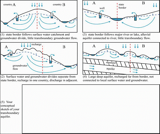
2-1 Please look at the four simplified pictures below and indicate which of them most closely characterises your transboundary aquifer. If none, please provide a conceptual sketch of your transboundary aquifer in the blank box below
![]()
![]()
![]()
![]()
![]() Please tick : Example 1 2 3 4
5
Please tick : Example 1 2 3 4
5
2-2 GENERAL CHARACTERISTICS
![]()
![]()
![]()
![]() Aquifer hydrogeological type: porous karstic fissured
rock other
Aquifer hydrogeological type: porous karstic fissured
rock other
Predominant lithology: Dolomite Limestone and Sandstone
Stratigraphic age: Cretaceous
Area extent (km2): 4 400 Population resident in this area and main occupation: -
Thickness: mean (m). : 50 maximum (m) 300
Shared international boundary length : not defined
Dominant groundwater flow direction: W-E from Morocco to Algeria
![]()
![]()
![]() Link with surface water
systems: strong medium weak
Link with surface water
systems: strong medium weak
No link with surface water
2.3 Map
Please provide a clear map of the transboundary aquifer, including aquifer boundaries and geographical coordinates. The map should preferably be supplied as a GIS-file
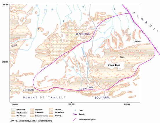
Chott Tigri-Lahouita region
2.4 Hydrogeological Characteristics and Groundwater Use
Rainfall: average annual and seasonal distribution: 170 mm / year. The precipitation period is from November to March-April
Recharge / discharge area: Aquifer is recharged mainly by infiltration from precipitation in Morocco. Aquifer is discharged through springs and pumping of groundwater.
Level changes (m/yr) - natural, induced by pumping, or other reason:
§ Natural Level changes (m/yr) : 0
§ Level changes induced by pumping and evaporation (m/yr) : 0
Total available non-renewable groundwater reserves (Mm3/yr):
Total available annually renewable groundwater resources (Mm3/yr): 11
Total groundwater abstractions (Mm3/yr) (estimated where not measured): 1.6 (Morocco side)
Flow in/out across national boundary (Mm3/yr): not defined
Groundwater flow direction and gradient across boundary: W-E From Morocco to Algeria
Water uses (total, by sector, principal uses, current - estimated and future - projected)
Total water use Mm3/yr : 1.6
§ Drinking water use Mm3/yr : 1.6
Deficits and other resource concerns (e.g. quality, extremes, environmental degradation, interactions with surface water bodies / other aquifers)
The chemical quality of the water of aquifer is good for the sand & sandstone formation and mediocre for limestone formation (Nitrate problem).
3- MONITORING DATA
Please note that stakeholders should comply with the WMO Resolution 25 on international exchange of hydrological and related data. (http://www.wmo.ch/index-en.html). If appropriate insert Excel tables into the Word document in order to provide information and available data on quantity, quality and accessibility, including:
· Observation networks
Describe the type of monitoring systems (surveillance, operational, investigative) and present briefly its historical perspective (starting year, changes of equipment or institutions and any other general information)
· Maps, with available scales, GIS and remote sensing imagery
Provide maps showing the monitoring stations in GIS format and any other relevant remote sensing information
· Type of data and monitoring equipment
Give the list of parameters and substances you monitor for quantity, physico-chemical and biological conditions and the monitoring equipment and methodology you use.
· Data archives and their adequacy
Describe the chronology of the data and give your opinion about their reliability
· Institutions in charge
Names and addresses of national and international institutions responsible for monitoring
· Research centres
Same as above for research centres involved in monitoring
3.1 Quantity
· No. of monitoring stations : 0
· Frequency of measurements : -
· Water levels : -
· Mean value and typical range : -
· Additional information : -
3.2 Quality
· No. of monitoring sites : 0
· Frequency of measurements : -
· Nitrogen compounds : -
· Salinity and major ions : -
· Heavy metals : -
· Pesticides : -
· Industrial organic compounds : -
4. IMPORTANCE OF TRANSBOUNDARY GROUNDWATERS
4-1 Uses and Functions
Does the groundwater in this transboundary aquifer have direct uses and/or other functions?
![]()
![]() No Why
not? Irrelevant groundwater resource
No Why
not? Irrelevant groundwater resource
![]() Problems with groundwater
Problems with groundwater
(if yes, indicate these in section 5)
or:
![]()
![]() Yes Uses Shared
Aquifer Groundwater as % of total water use in the area
Yes Uses Shared
Aquifer Groundwater as % of total water use in the area
Total Shared Groundwater as % of total water use in the country:
Total Groundwater as % of total water use in the country:
![]()
![]() Other functions Support of ecosystems
Other functions Support of ecosystems
![]() Support of agriculture
Support of agriculture
(Directly from shallow water table)
![]() Preventing
land subsidence
Preventing
land subsidence
![]() Maintaining baseflow and springs
Maintaining baseflow and springs
![]() Seasonal
heat storage
Seasonal
heat storage
![]() Any
other function
Any
other function
(please specify)
Drinking water supply
4-2 Groundwater abstraction and use in the aquifer
Indicate in the table the percentage of total groundwater abstraction accounted for by each use
|
Type of use |
Percentage |
If you do not know the exact percentage, than mark one of the following options |
|||
|
< 25 % |
25 – 50 % |
50 – 75 % |
> 75 % |
||
|
Drinking water |
100 |
|
|
|
|
|
Irrigation |
|
|
|
|
|
|
Industry |
|
|
|
|
|
|
Mining |
|
|
|
|
|
|
Thermal spa |
|
|
|
|
|
|
Livestock |
|
|
|
|
|
|
Other (please specify) |
|||||
|
|
|
|
|
|
|
|
|
|
|
|
|
|
Please indicate the year to which these figures apply: 2004
5. WHICH PROBLEMS ARE OBSERVED IN TRANSBOUNDARY GROUNDWATERS?
5.1 Problems related to groundwater quantity
a) Specify if possible the average trend of groundwater level decline (m/year) : 0
b) Indicate in the table the type and scale of problem associated with groundwater abstraction from the aquifer
|
Problem |
|
|||
|
1. Local and moderate |
2. Local but severe |
3. Widespread but moderate |
4. Widespread and severe |
|
|
Increased pumping lifts or costs |
|
|
|
|
|
Reduction of borehole yields |
|
|
|
|
|
Reduced baseflow and springflow |
|
|
|
|
|
Degradation of ecosystems |
|
|
|
|
|
Sea water intrusion |
|
|
|
|
|
Salt water upconing |
|
|
|
|
|
Polluted water drawn into aquifer |
|
|
|
|
|
Land subsidence |
|
|
|
|
|
Other (please specify) |
||||
|
|
|
|
|
|
|
|
|
|
|
|
5.2 Problems related to groundwater quality
Indicate in the table the type, nature and scale of groundwater quality problems in the aquifer
|
Problem |
Nature of problem |
Typical range of concentrations |
Scale, using classes 1-4 from table above |
|
|
Natural origins |
From human activities |
|||
|
Salinisation |
|
|
1 |
|
|
Nitrogen species |
|
|
|
|
|
Pesticides |
|
|
|
|
|
Heavy metals |
|
|
|
|
|
Pathogens |
|
|
|
|
|
Industrial organic compounds |
|
|
|
|
|
Hydrocarbons |
|
|
|
|
|
Other (please specify) |
||||
|
Nitrate |
+ |
|
|
1 |
|
|
|
|
|
|
5.3 Evidence for transboundary effects
b) Do you observe any decline of groundwater levels (or piezometric levels) caused or probably caused by activities in neighbouring countries?
![]()
![]() Yes
No
Yes
No
c) Do you observe any groundwater pollution caused or probably caused by activities in neighbouring countries?
![]()
![]() Yes No
Yes No
6. TRANSBOUNDARY MANAGEMENT MEASURES
Indicate in the table which measures are presently being implemented or need to be applied
|
Management Measures |
Already used and effective |
Used, but Need to be improved |
Need to be applied |
Currently planned |
|
Transboundary institutions (commissions, agreements, treaties, etc.) |
|
|
+ |
|
|
Groundwater abstraction management by regulation (licensing, taxation) |
|
+ |
|
|
|
Groundwater abstraction management by incentives or disincentives (subsidies, credits, energy prices, energy supply, etc.) |
|
|
+ |
|
|
Increasing efficiency of groundwater use |
|
+ |
|
|
|
Monitoring of groundwater quantity |
|
+ |
|
|
|
Monitoring of groundwater quality |
|
|
+ |
|
|
Public awareness campaigns |
|
|
+ |
|
|
Protection zones for public supplies |
|
|
+ |
|
|
Vulnerability mapping for land use planning |
|
|
+ |
|
|
Good agricultural practices |
|
|
+ |
|
|
Groundwater integrated into river basin management |
|
|
|
|
|
Wastewater reuse or artificial recharge |
|
|
|
|
|
Treatment of urban wastewater |
|
|
|
|
|
Treatment of industrial effluents |
|
|
|
|
|
Other (please specify) |
||||
|
|
|
|
|
|
|
|
|
|
|
|
|
|
|
|
|
|
7. POLICY AND LEGISLATIVE PROPERTIES
- Does your country have domestic legislation on water resources ? è yes. In particular, does this legislation include a part on groundwater resources, or is there a separate groundwater legislation? èit includes a part of groundwater resources. Could you give an indication of the main provisions concerning groundwater, such as abstraction, licensing, pollution prevention zoning mechanisms etc.
- What is the governmental institutional set-up for water management in your country, at national and sub-national level? (Give full name of institution(s), and a brief description of the relevant internal structure and mandate). è Is there any specific government institution for groundwater management? èyes
- Are there any arrangements or agreements with your neighboring States regarding the transboundary aquifers ? èNo. Is there any form of cooperation with the neighboring States on the transboundary aquifers? èNo
8. NAME AND CONTACT DETAILS OF PERSON(S) COMPLETING THIS FORM:
Name : FILALI MOUTEI Jaouad
Institution : Secretary of State to the Ministry of Energy, Mining, Water and Environment, in charge of Water and Environment
Address… : Administration de l’Hydraulique 20, Rue Hassan Ben Chekroun, Rabat Agdal, Maroc
Tel. : (+212) 37 68 58 24 Fax. (+212) 37 77 60 81 E-mail : fmjaouad@water.gov.ma